
Íomhá:Yorubaland location map.png
Níl aon taifeach is mó ar fáil.
Yorubaland_location_map.png (250 × 115 picteilín, méid comhaid: 8 KB, cineál MIME: image/png)
| Seo comhad as An Cómhaoin Viciméid. Tá an tuairisc as an leathanach tuairisc Cómhaoin a leanas thíos.
|

|
This locator map image could be re-created using vector graphics as an SVG file. This has several advantages; see Commons:Media for cleanup for more information. If an SVG form of this image is available, please upload it and afterwards replace this template with
{{vector version available|new image name}}.
It is recommended to name the SVG file “Yorubaland location map.svg”—then the template Vector version available (or Vva) does not need the new image name parameter. |
Achoimriú
| Tuairisc |
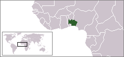
English: Location of Yorubaland
Euskara: Joruba Herriaren koakalekua erakusten duen mapa. |
| Dáta | (UTC) |
| Foinse |
This file was derived from: LocationIgboland.png |
| Údar | Ukabia |
Ceadúnú
This file is licensed under the Creative Commons Attribution-Share Alike 3.0 Unported license.
- Is féidir:
- an saothar seo a roinnt – an saothar seo a chóipeáil, a dháil amach, agus a tharchur
- an saothar seo a athmheascadh – an saothar seo a oiriúnú
- Ach amháin má leantar na coinníollacha seo a leanas:
- sannadh – Ní mor creidiúint a thabhairt leis an saothar, faoi mar a shonraigh an údar nó tabharthóir an ceadúnais (ach ná húsáid modh a thugann le fios go thacaíonn sé/sí tú féin nó an úsáid a bhaineann tú as an saothar).
- comhroinn araon – Má athraíonn tú nó síneann tú amach an saothar seo, ní féidir é a dháileadh ach amhaín faoin gceadúnas céanna nó ceann cosúil leis an gceann seo.
Original upload log
Transferred from en.wikipedia to Commons by Xabier Armendaritz.
The original description page was here. All following user names refer to en.wikipedia.
- 2010-08-27 17:29 Brout8 250×115× (8195 bytes) {{Information |Description = Location of yorubaland |Source = http://en.wikipedia.org/wiki/File:LocationIgboland.png |Date = ~~~~~ |Author = Ukabia |Permission = |other_versions = }}
Stair chomhaid
Cliceáil ar dáta/am chun an comhad a radharc mar a bhí sé ag an am sin.
| Dáta/Am | Mionsamhail | Toisí | Úsáideoir | Nóta tráchta | |
|---|---|---|---|---|---|
| faoi láthair | 12:20, 24 Deireadh Fómhair 2012 | | 250 × 115 (8 KB) | Xabier Armendaritz | {{Information |Description ={{en|1=Location of Yorubaland}} {{eu|1=Joruba Herriaren koakalekua erakusten duen mapa.}} |Source =Transferred from [http://en.wikipedia.org en.wikipedia] by User:Xabier Armendaritz. |Author =Ukabia |D... |
Úsáid comhaid
Tá nasc chuig an gcomhad seo ar na leathanaigh seo a leanas:
Global file usage
The following other wikis use this file:
- Úsáid ar af.wikipedia.org
- Úsáid ar bg.wikipedia.org
- Úsáid ar ca.wikipedia.org
- Úsáid ar en.wikipedia.org
- Úsáid ar eu.wikipedia.org
- Úsáid ar oc.wikipedia.org
- Úsáid ar ta.wikipedia.org
- Úsáid ar tt.wikipedia.org
- Úsáid ar www.wikidata.org