
Íomhá:Brumadinho dam catastrophy 2.jpg
Taispeáin leagan ardtaifigh den íomhá (2,400 × 1,456 picteilín, méid comhaid: 5.35 MB, cineál MIME: image/jpeg)
| Seo comhad as An Cómhaoin Viciméid. Tá an tuairisc as an leathanach tuairisc Cómhaoin a leanas thíos.
|
Achoimriú
| Tuairisc |
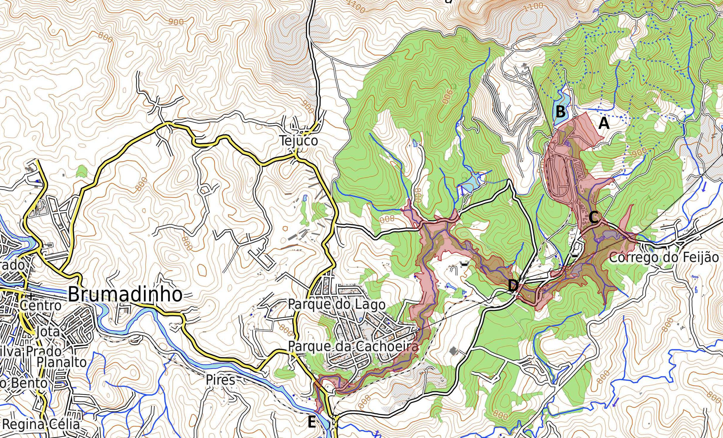
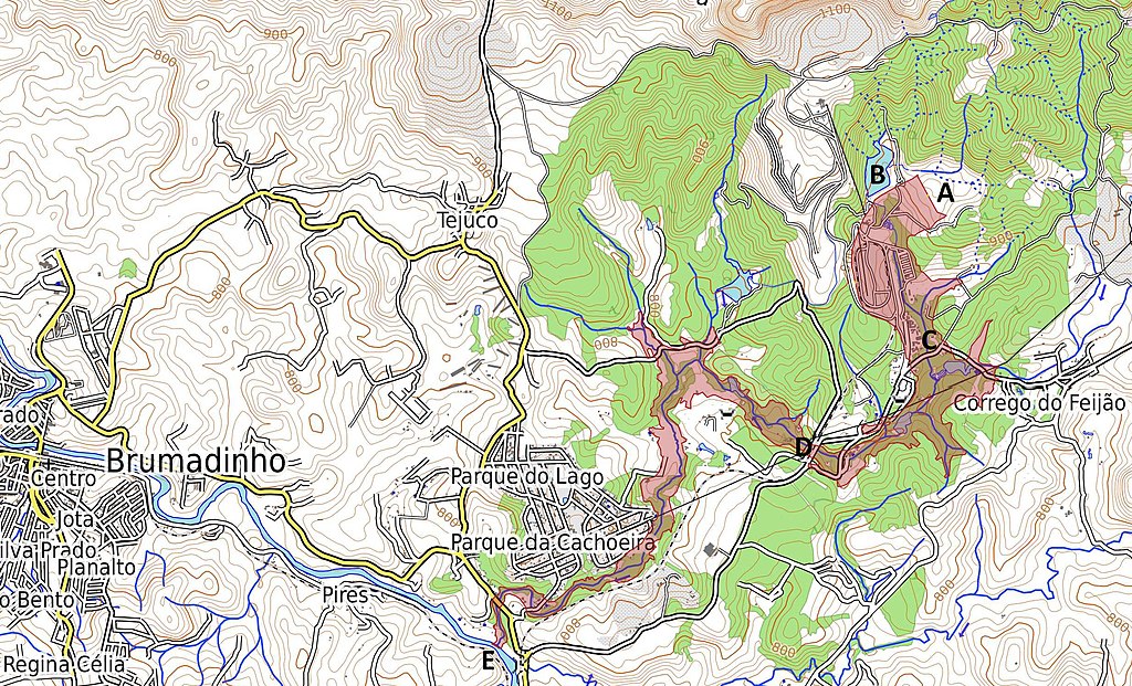
English: Map of tailings dam collapse disaster east of Brumadinho at the Mina Córrego do Feijão. Highlighted in red is the coverage and destruction of the mine dump and debris after the collapse. A Location of destroyed dam and former tailings pond "Barragem I". B Location of second tailings pond "Barragem VI" with destabilized dam, due to the event. C Location of the destroyed office buildings and the cantina of the mine at Vila Ferteco. D Location of the destroyed railway bridge. E Location of the entry point of the mud flood into the river Rio Paraopeba. Português: Mapa da área atingida pelos rejeitos da barragem. A Barragem I - destruída. B Barragem VI - instável. C Vila Ferteco - área administrativa da mina. D Ponte destruída. E Às 15h50min os rejeitos que vazaram da Mina de Feijão atingiram o rio Paraopeba. Deutsch: Karte der Folgen des Dammbruchs bei der Grube Mina Córrego do Feijão östlich des Ortes Brumadinho. In roter Farbe hervorgehoben ist die Bedeckung und Verwüstung durch die Schlammlawine. A Zerstörter Damm des Absetzbeckens "Barragem I". B Benachbartes Absetzbecken "Barragem VI", dessen Damm durch den Vorfall stark beschädigt wurde. C Vila Ferteco - zerstörte Büros und Kantine der Bergbaugesellschaft. D zerstörte Eisenbahnbrücke. E Eintritt der Schlammlawine in den Fluss Paraopeba. |
| Dáta | |
| Foinse | Map Dataː OpenStreetMap.org contributors. Map styleː OpenTopoMap.org [1] with SRTM data (Shuttle Radar Topography Mission). Shape of mud flow from dam collapseː Sentinel Satellite S2-L1C 2019-01-27 TCI/NDWI/NDVI at sentinel-hub.com via OpenStreetMap.org contributors layer [2] |
| Údar | ESA / Copernicus Sentinel-2A-L1C Satellite and OpenStreetMap.org contributors |
Ceadúnú
- Is féidir:
- an saothar seo a roinnt – an saothar seo a chóipeáil, a dháil amach, agus a tharchur
- an saothar seo a athmheascadh – an saothar seo a oiriúnú
- Ach amháin má leantar na coinníollacha seo a leanas:
- sannadh – Ní mor creidiúint a thabhairt leis an saothar, faoi mar a shonraigh an údar nó tabharthóir an ceadúnais (ach ná húsáid modh a thugann le fios go thacaíonn sé/sí tú féin nó an úsáid a bhaineann tú as an saothar).
- comhroinn araon – Má athraíonn tú nó síneann tú amach an saothar seo, ní féidir é a dháileadh ach amhaín faoin gceadúnas céanna nó ceann cosúil leis an gceann seo.

|
This image contains data from a satellite in the Copernicus Programme, such as Sentinel-1, Sentinel-2 or Sentinel-3. Attribution is required when using this image.
Creidiúint: Contains modified Copernicus Sentinel data 2019
The use of Copernicus Sentinel Data is regulated under EU law (Commission Delegated Regulation (EU) No 1159/2013 and Regulation (EU) No 377/2014). Relevant excerpts:
Free access shall be given to GMES dedicated data [...] made available through GMES dissemination platforms [...].
Access to GMES dedicated data [...] shall be given for the purpose of the following use in so far as it is lawful:
GMES dedicated data [...] may be used worldwide without limitations in time.
GMES dedicated data and GMES service information are provided to users without any express or implied warranty, including as regards quality and suitability for any purpose. |
Stair chomhaid
Cliceáil ar dáta/am chun an comhad a radharc mar a bhí sé ag an am sin.
| Dáta/Am | Mionsamhail | Toisí | Úsáideoir | Nóta tráchta | |
|---|---|---|---|---|---|
| faoi láthair | 20:56, 30 Eanáir 2019 | | 2,400 × 1,456 (5.35 MB) | Agricolax | User created page with UploadWizard |
Úsáid comhaid
Tá nasc chuig an gcomhad seo ar na leathanaigh seo a leanas:
Global file usage
The following other wikis use this file:
- Úsáid ar cy.wikipedia.org
- Úsáid ar de.wikipedia.org
- Úsáid ar en.wikipedia.org
- Úsáid ar es.wikipedia.org
- Úsáid ar fi.wikipedia.org
- Úsáid ar he.wikipedia.org
- Úsáid ar hu.wikipedia.org
- Úsáid ar ig.wikipedia.org
- Úsáid ar ja.wikipedia.org
- Úsáid ar mk.wikipedia.org
- Úsáid ar pt.wikipedia.org
- Úsáid ar vi.wikipedia.org
- Úsáid ar www.wikidata.org