
Íomhá:London north-south circulars.svg

Size of this PNG preview of this SVG file: 715 × 600 picteilín. Other resolutions: 286 × 240 picteilín | 572 × 480 picteilín | 916 × 768 picteilín | 1,221 × 1,024 picteilín | 2,442 × 2,048 picteilín | 4,542 × 3,809 picteilín.
Taispeáin leagan ardtaifigh den íomhá (Comhad SVG, ainmniúil 4,542 × 3,809 picteilíni, méid comhaid: 46 KB)
| Seo comhad as An Cómhaoin Viciméid. Tá an tuairisc as an leathanach tuairisc Cómhaoin a leanas thíos.
|

Achoimriú
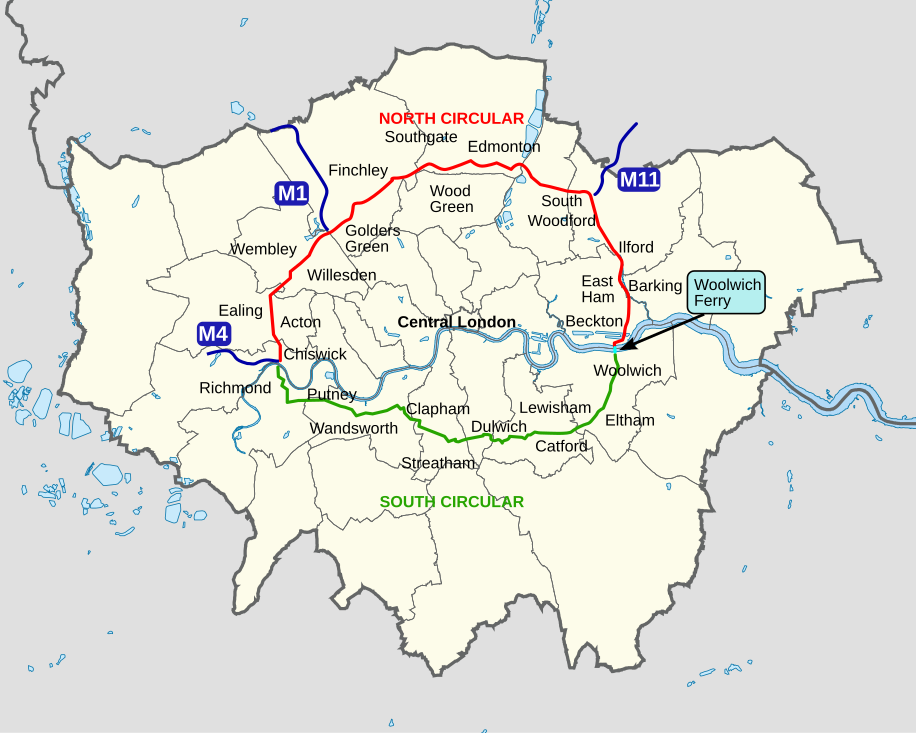
| Tuairisc | An outline map of the North Circular and South Circular roads, including the Woolwich Ferry linking the two. |
| Dáta | |
| Foinse | Obair féin |
| Údar | Cnbrb |
Ceadúnú
| I, the copyright holder of this work, release this work into the public domain. This applies worldwide. In some countries this may not be legally possible; if so: I grant anyone the right to use this work for any purpose, without any conditions, unless such conditions are required by law. |
Stair chomhaid
Cliceáil ar dáta/am chun an comhad a radharc mar a bhí sé ag an am sin.
| Dáta/Am | Mionsamhail | Toisí | Úsáideoir | Nóta tráchta | |
|---|---|---|---|---|---|
| faoi láthair | 11:45, 29 Deireadh Fómhair 2022 | | 4,542 × 3,809 (46 KB) | Hanif Al Husaini | Lighten background to make higher contrast with the green text and line for the South Circular |
| 01:17, 13 Bealtaine 2019 |  | 4,542 × 3,809 (46 KB) | MetrolandNW | Further pinpoint fixes for accuracy, added other notable places | |
| 22:00, 11 Bealtaine 2019 |  | 4,542 × 3,809 (43 KB) | MetrolandNW | Fixes for place names (now mentions major places near/on the roads), corrected words' locations for accuracy ('Friern Barnet' especially was extremely unaccurate), coloured 'NORTH CIRCULAR' and 'SOUTH CIRCULAR' (to their respective lines' colours) | |
| 22:15, 24 Márta 2008 |  | 4,542 × 3,809 (39 KB) | Cnbrb | {{Information |Description=An outline map of the North Circular and South Circular roads, including the Woolwich Ferry linking the two. |Source=self-made |Date=2008-03-24 |Author= Cnbrb |Permission= |other_versions= }} | |
| 22:01, 24 Márta 2008 |  | 4,542 × 3,809 (40 KB) | Cnbrb | {{Information |Description=An outline map of the North Circular and South Circular roads, including the Woolwich Ferry linking the two. |Source=self-made |Date=2008-03-24 |Author= Cnbrb |Permission= |other_versions= }} |
Úsáid comhaid
Tá nasc chuig an gcomhad seo ar na leathanaigh seo a leanas:
Global file usage
The following other wikis use this file:
- Úsáid ar en.wikipedia.org
- Úsáid ar no.wikipedia.org
- Úsáid ar simple.wikipedia.org
- Úsáid ar uk.wikipedia.org
- Úsáid ar www.wikidata.org