
Íomhá:Guyana-CIA WFB Map.png
Níl aon taifeach is mó ar fáil.
Guyana-CIA_WFB_Map.png (329 × 353 picteilín, méid comhaid: 17 KB, cineál MIME: image/png)
| Seo comhad as An Cómhaoin Viciméid. Tá an tuairisc as an leathanach tuairisc Cómhaoin a leanas thíos.
|
Achoimriú
| Tuairisc |
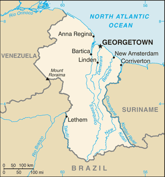
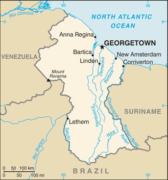
English: Map of Guyana.
Français : Carte du Guyana.
Italiano: Mappa della Guyana. |
|||
| Dáta | ||||
| Foinse | https://www.cia.gov/the-world-factbook/static/maps/GY-map.jpg | |||
| Údar | Directorate of Intelligence, CIA | |||
| Ceadúnas (Athúsáid a bhaint as an gcomhad seo) |
|
|||
| Leaganacha eile |
|


Stair chomhaid
Cliceáil ar dáta/am chun an comhad a radharc mar a bhí sé ag an am sin.
| Dáta/Am | Mionsamhail | Toisí | Úsáideoir | Nóta tráchta | |
|---|---|---|---|---|---|
| faoi láthair | 08:02, 21 Iúil 2007 | | 329 × 353 (17 KB) | Hoshie | Updated map of Guyana from the CIA World Factbook, 14 June 07 rev. Src: https://www.cia.gov/library/publications/the-world-factbook/maps/gy-map.gif |
| 09:14, 27 Márta 2005 |  | 329 × 706 (10 KB) | Wolfman~commonswiki | {{CIA-map}} |
Úsáid comhaid
Níl nasc ó aon leathanach eile don íomhá seo.
Global file usage
The following other wikis use this file:
- Úsáid ar af.wikipedia.org
- Úsáid ar be-tarask.wikipedia.org
- Úsáid ar de.wikipedia.org
- Úsáid ar de.wiktionary.org
- Úsáid ar dsb.wikipedia.org
- Úsáid ar en.wikipedia.org
- Úsáid ar en.wikinews.org
- Úsáid ar en.wikisource.org
- Úsáid ar eo.wikipedia.org
- Úsáid ar es.wikipedia.org
- Úsáid ar fa.wikipedia.org
- Úsáid ar fi.wikipedia.org
- Úsáid ar frr.wikipedia.org
- Úsáid ar fy.wikipedia.org
- Úsáid ar gom.wikipedia.org
- Úsáid ar hi.wikipedia.org
- Úsáid ar hr.wikipedia.org
- Úsáid ar hu.wikipedia.org
- Úsáid ar it.wikipedia.org
- Úsáid ar ja.wikipedia.org
- Úsáid ar kn.wikipedia.org
- Úsáid ar la.wikipedia.org
- Úsáid ar lb.wikipedia.org
- Úsáid ar lfn.wikipedia.org
- Úsáid ar lld.wikipedia.org
- Úsáid ar lt.wiktionary.org
- Úsáid ar ml.wikipedia.org
View more global usage of this file.