
Íomhá:Gaza Strip map.png

Size of this preview: 492 × 600 picteilín. Other resolutions: 197 × 240 picteilín | 394 × 480 picteilín | 984 × 1,200 picteilín.
Taispeáin leagan ardtaifigh den íomhá (984 × 1,200 picteilín, méid comhaid: 343 KB, cineál MIME: image/png)
| Seo comhad as An Cómhaoin Viciméid. Tá an tuairisc as an leathanach tuairisc Cómhaoin a leanas thíos.
|
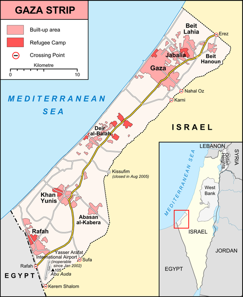
| Tuairisc |
English: Map of Gaza Strip, Stand December 2008 |
|||
| Dáta | ||||
| Foinse |
own work, used:
|
|||
| Údar | Lencer | |||
| Leaganacha eile |
[] Ver1:
Ver2:
|


Ceadúnú
This file is licensed under the Creative Commons Attribution-Share Alike 3.0 Unported license.
- Is féidir:
- an saothar seo a roinnt – an saothar seo a chóipeáil, a dháil amach, agus a tharchur
- an saothar seo a athmheascadh – an saothar seo a oiriúnú
- Ach amháin má leantar na coinníollacha seo a leanas:
- sannadh – Ní mor creidiúint a thabhairt leis an saothar, faoi mar a shonraigh an údar nó tabharthóir an ceadúnais (ach ná húsáid modh a thugann le fios go thacaíonn sé/sí tú féin nó an úsáid a bhaineann tú as an saothar).
- comhroinn araon – Má athraíonn tú nó síneann tú amach an saothar seo, ní féidir é a dháileadh ach amhaín faoin gceadúnas céanna nó ceann cosúil leis an gceann seo.

|
This map has been made or improved in the German Kartenwerkstatt (Map Lab). You can propose maps to improve as well.
|
Stair chomhaid
Cliceáil ar dáta/am chun an comhad a radharc mar a bhí sé ag an am sin.
| Dáta/Am | Mionsamhail | Toisí | Úsáideoir | Nóta tráchta | |
|---|---|---|---|---|---|
| faoi láthair | 20:42, 6 Eanáir 2009 | | 984 × 1,200 (343 KB) | Lencer | {{Information |Description= |Source= |Date= |Author= |Permission= |other_versions= }} |
| 20:06, 6 Eanáir 2009 |  | 984 × 1,200 (343 KB) | Lencer | {{Information| |Description=Map of Gaza Strip, Stand December 2008 |Source=own work, used: * [http://unosat.web.cern.ch/unosat/asp/prod_free.asp?pid=1304 UNOSAT, Situation Map-Gaza Crisis] * [http://www.ochaopt.org/gazacrisis/admin/outp |
Úsáid comhaid
Níl nasc ó aon leathanach eile don íomhá seo.
Global file usage
The following other wikis use this file:
- Úsáid ar be.wikipedia.org
- Úsáid ar da.wikipedia.org
- Úsáid ar de.wikipedia.org
- Úsáid ar de.wikinews.org
- Úsáid ar en.wikipedia.org
- Úsáid ar fr.wikipedia.org
- Úsáid ar hy.wikipedia.org
- Úsáid ar li.wikinews.org
- Úsáid ar no.wikipedia.org
- Úsáid ar ru.wikipedia.org
- Úsáid ar sv.wikipedia.org
- Úsáid ar tt.wikipedia.org
- Úsáid ar vep.wikipedia.org