
Íomhá:China Inner Mongolia.svg

Size of this PNG preview of this SVG file: 705 × 599 picteilín. Other resolutions: 282 × 240 picteilín | 565 × 480 picteilín | 904 × 768 picteilín | 1,205 × 1,024 picteilín | 2,409 × 2,048 picteilín | 1,000 × 850 picteilín.
Taispeáin leagan ardtaifigh den íomhá (Comhad SVG, ainmniúil 1,000 × 850 picteilíni, méid comhaid: 214 KB)
| Seo comhad as An Cómhaoin Viciméid. Tá an tuairisc as an leathanach tuairisc Cómhaoin a leanas thíos.
|
| Tuairisc |
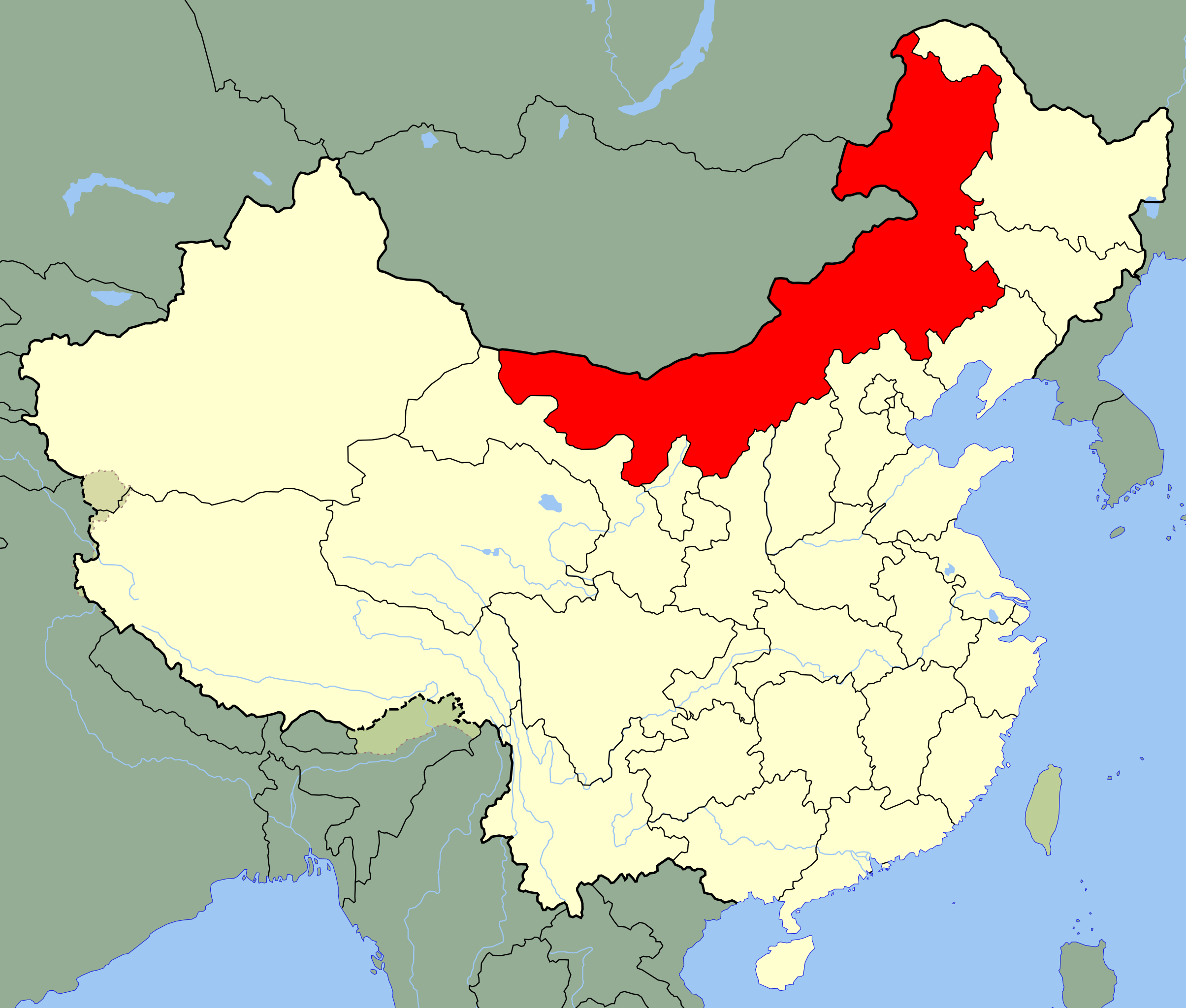
An SVG map of China with the Inner Mongolia autonomous region highlighted Legend: |
||
| Dáta | |||
| Foinse |
self-made; based on CIA public domain maps: |
||
| Údar | Joowwww | ||
| Ceadúnas (Athúsáid a bhaint as an gcomhad seo) |
|
||
| Leaganacha eile |
|
Stair chomhaid
Cliceáil ar dáta/am chun an comhad a radharc mar a bhí sé ag an am sin.
| Dáta/Am | Mionsamhail | Toisí | Úsáideoir | Nóta tráchta | |
|---|---|---|---|---|---|
| faoi láthair | 16:24, 13 Lúnasa 2008 | | 1,000 × 850 (214 KB) | Joowwww | added missing laos/vietnam border |
| 11:16, 14 Bealtaine 2008 |  | 1,000 × 850 (213 KB) | Joowwww | {{Information |Description=An SVG map of China with the Inner Mongolia autonomous region highlighted Legend:<br />Image:China map legend.png |Source=self-made; based on CIA public domain maps: *http://www.lib.utexas.edu/maps/middle_east_and_asia/chin |
Úsáid comhaid
Níl nasc ó aon leathanach eile don íomhá seo.
Global file usage
The following other wikis use this file:
- Úsáid ar ace.wikipedia.org
- Úsáid ar ar.wikipedia.org
- Úsáid ar bo.wikipedia.org
- Úsáid ar br.wikipedia.org
- Úsáid ar bs.wikipedia.org
- Úsáid ar bxr.wikipedia.org
- Úsáid ar cdo.wikipedia.org
- Úsáid ar cs.wikipedia.org
- Úsáid ar en.wikipedia.org
- Úsáid ar eo.wikipedia.org
- Úsáid ar es.wikipedia.org
- Úsáid ar et.wikipedia.org
- Úsáid ar eu.wikipedia.org
- Úsáid ar fa.wikipedia.org
- Úsáid ar fr.wikipedia.org
- Úsáid ar fr.wikivoyage.org
View more global usage of this file.