
Íomhá:Achaemenid empire map expansion.png
Size of this preview: 800 × 511 picteilín. Other resolutions: 320 × 205 picteilín | 640 × 409 picteilín | 1,020 × 652 picteilín.
Taispeáin leagan ardtaifigh den íomhá (1,020 × 652 picteilín, méid comhaid: 34 KB, cineál MIME: image/png)
| Seo comhad as An Cómhaoin Viciméid. Tá an tuairisc as an leathanach tuairisc Cómhaoin a leanas thíos.
|
Achoimriú
| Tuairisc |
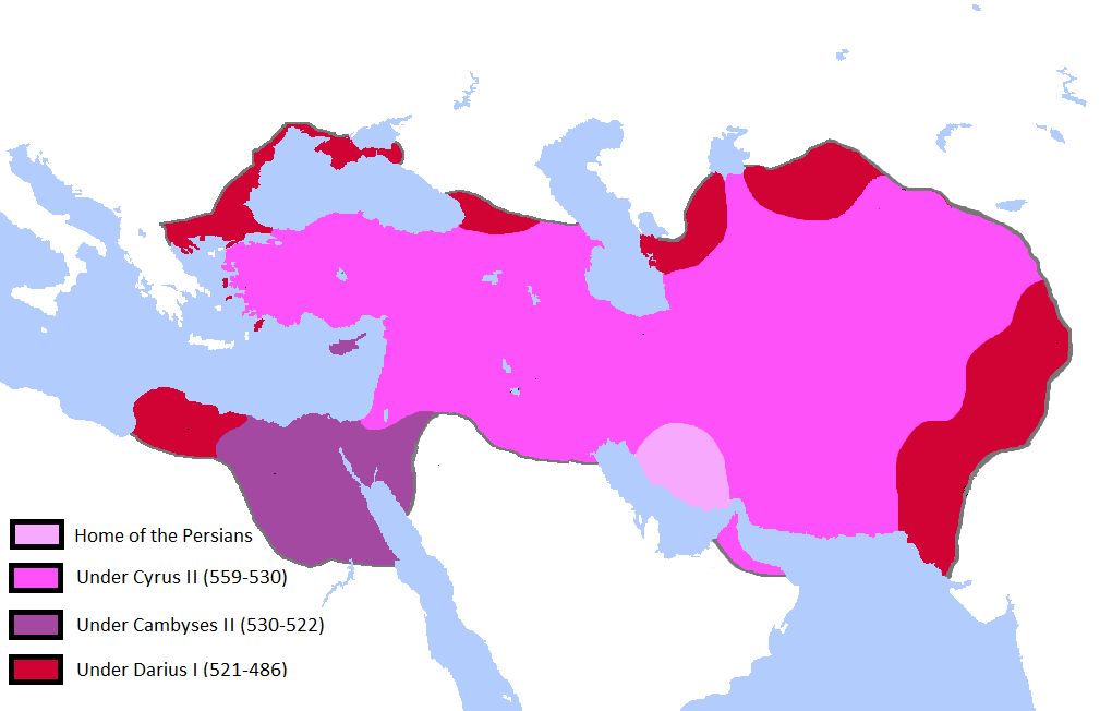
English: Updated the map by delineating the conquests of the three major Persian conqueror Kings, and also adding the names of the main satrapies of the empire. As a source I used this map of Ian Mladjov's Resources from the University of Michigan's History department. Link:http://sitemaker.umich.edu/mladjov/home |
| Dáta | |
| Foinse | On Microsoft Paint |
| Údar | Javierfv1212 |
Ceadúnú
Is mise sealbhóir cóipchirt an shaothair seo agus foilsím é faoi na ceadúnais seo a leanas:

|
Tugtar cead an doiciméad seo a chóipeáil, a dháileadh agus/nó a mhodhnú faoi théarmaí an Ceadúnas Doiciméadúcháin Saor ó GNU, Leagan 1.2 nó aon leagan níos déanaí a d’fhoilsigh an Fondúireacht Bogearraí Saor in Aisce; gan aon Rannóga Inmheánacha, gan aon Téacsanna Clúdaigh Tosaigh, agus gan aon Téacsanna Clúdaigh Cúil. Tá cóip den cheadúnas san áireamh sa chuid dar teideal Ceadúnas Doiciméadúcháin Saor ó GNU. |
This file is licensed under the Creative Commons Attribution-Share Alike 3.0 Unported license.
- Is féidir:
- an saothar seo a roinnt – an saothar seo a chóipeáil, a dháil amach, agus a tharchur
- an saothar seo a athmheascadh – an saothar seo a oiriúnú
- Ach amháin má leantar na coinníollacha seo a leanas:
- sannadh – Ní mor creidiúint a thabhairt leis an saothar, faoi mar a shonraigh an údar nó tabharthóir an ceadúnais (ach ná húsáid modh a thugann le fios go thacaíonn sé/sí tú féin nó an úsáid a bhaineann tú as an saothar).
- comhroinn araon – Má athraíonn tú nó síneann tú amach an saothar seo, ní féidir é a dháileadh ach amhaín faoin gceadúnas céanna nó ceann cosúil leis an gceann seo.
Is féidir leat a roghnú an ceadúnas do rogha
Stair chomhaid
Cliceáil ar dáta/am chun an comhad a radharc mar a bhí sé ag an am sin.
| Dáta/Am | Mionsamhail | Toisí | Úsáideoir | Nóta tráchta | |
|---|---|---|---|---|---|
| faoi láthair | 00:41, 14 Deireadh Fómhair 2015 | | 1,020 × 652 (34 KB) | LouisAragon | Reverted mostly hoax edits (except Macedon) by user:HistoryofPersia |
| 23:40, 11 Deireadh Fómhair 2015 |  | 1,012 × 648 (34 KB) | History of Persia | macedonia | |
| 17:29, 3 Lúnasa 2015 |  | 1,012 × 648 (32 KB) | History of Persia | There is no account saying cambyses conquered cyprus (the island), so it is more likely that it was conquered by cyrus, and became part of the babylonian province (which became the eber-nari province | |
| 16:51, 3 Lúnasa 2015 |  | 1,012 × 648 (32 KB) | History of Persia | Cambyses did not subdue the arabs in his egyptian campaign. achaemenid arabia only appears in an inscription from the reign of darius. But it is possible that (along with eber nari), arabia was originally part of the babylonian province but later split... | |
| 00:08, 2 Lúnasa 2015 |  | 1,012 × 648 (32 KB) | History of Persia | Gandhara empires borders where more like this version of the file. evidence: http://www.worldhistorymaps.info/images/East-Hem_600bc.jpg & https://en.wikipedia.org/wiki/Gandhara_Kingdom#/media/File:Gandhara.JPG. no one noticed until now i guess | |
| 23:45, 1 Lúnasa 2015 |  | 1,020 × 652 (34 KB) | History of Persia | Added territories of the gandhara kingdom and a more likely border of gedrosia | |
| 16:13, 27 Iúil 2015 |  | 1,020 × 652 (34 KB) | History of Persia | Cyrus created cyropolis | |
| 06:59, 16 Iúil 2015 |  | 1,020 × 652 (34 KB) | History of Persia | if readers want to see the provinces/satrapies they can see another map. For the map of the empire we dont need the inclusion of satrapies. | |
| 23:42, 26 Feabhra 2015 |  | 1,020 × 652 (59 KB) | Javierfv1212 | {{subst:Upload marker added by en.wp UW}} {{Information |Description = {{en|Updated the map by delineating the conquests of the three major Persian conqueror Kings, and also adding the names of the main satrapies of the empire. As a source I used this... |
Úsáid comhaid
Níl nasc ó aon leathanach eile don íomhá seo.
Global file usage
The following other wikis use this file:
- Úsáid ar ar.wikipedia.org
- Úsáid ar en.wikipedia.org
- Úsáid ar hy.wikipedia.org
- Úsáid ar hyw.wikipedia.org
- Úsáid ar ku.wikipedia.org
- Úsáid ar pt.wikipedia.org
- Úsáid ar tr.wikipedia.org