
Íomhá:Ireland geographical map.png
Níl aon taifeach is mó ar fáil.
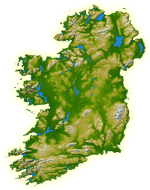
Ireland_geographical_map.png (150 × 190 picteilín, méid comhaid: 50 KB, cineál MIME: image/png)
| Seo comhad as An Cómhaoin Viciméid. Tá an tuairisc as an leathanach tuairisc Cómhaoin a leanas thíos.
|
| Tuairisc |
English: Topography of Ireland |
| Dáta | IotD Date 2005-03-18 |
| Foinse |
NASA: IotD ID 16853 – http://visibleearth.nasa.gov/view_rec.php?id=17124 |
| Údar | NASA, see Image:Topography Ireland.jpg for more information |
| Ceadúnas (Athúsáid a bhaint as an gcomhad seo) |
public domain |
| Leaganacha eile | original, bigger version at Image:Topography Ireland.jpg |
| Chruthaigh NASA an comhad seo, agus tógadh as suíomh Greasáin NASA nó foilseachán NASA é. Tá gach saothar den saghas sin sa fearann poiblí ach amháin an suaitheantas NASA, mar ní féidir saothair de chuid rialtas cónaidhme Stáit Aontaithe Mheiriceá a chur faoi chóipcheart. Féach ar an leathanach pholasaí cóipchirt NASA nó an leathanach pholasaí íomhanna JPL le tuilleadh eolais. | ||
 |
Rabhaidh:
|
Stair chomhaid
Cliceáil ar dáta/am chun an comhad a radharc mar a bhí sé ag an am sin.
| Dáta/Am | Mionsamhail | Toisí | Úsáideoir | Nóta tráchta | |
|---|---|---|---|---|---|
| faoi láthair | 11:39, 11 Iúil 2005 | | 150 × 190 (50 KB) | Kanchelskis | Map of Ireland lightened. Author:me {{GFDL}} Category: Ireland |
Úsáid comhaid
Níl nasc ó aon leathanach eile don íomhá seo.
Global file usage
The following other wikis use this file:
- Úsáid ar de.wikipedia.org
- Úsáid ar en.wikipedia.org
- User:Jtdirl
- User:Kwekubo
- Dingle Peninsula
- User:Zoney
- Iveragh Peninsula
- User:Ropers
- User:Gerry Lynch
- User:AndrewH
- User:Ebelular
- Inishowen
- User:Fergananim
- Mizen Head
- Sheep's Head
- Old Head of Kinsale
- User:Rye 212
- Ards Peninsula
- User:Blorg
- User:Wexfordman
- User:Meabhar~enwiki
- Howth Head
- User:Sean3000
- User:Notjim
- User:Jasonm
- User:Kgaughan
- Beara Peninsula
- User:John Carroll
- User:Bjimba
- User talk:Lochaber
- Fanad
- User:Hetch
- Islandmagee
- User:Wikipedian231
- User:Jdorney
- User:Merlante
- User:Lugnad
- Slieve League
- User:Ben-w
- Hook Peninsula
- User:Polar ice
- User:Dowlingm
- User:Frure
- User:Ventolin
- User:Dkie
- User:Colm Rice
- Mullaghmore, County Sligo
- User:Damac
- User:Ian Cheese
- User:Tpower
- User:Raemie
View more global usage of this file.