
Íomhá:Xinjiang Internment Map, US-Aus Gov Assessment.jpg
Size of this preview: 800 × 495 picteilín. Other resolutions: 320 × 198 picteilín | 640 × 396 picteilín | 1,024 × 634 picteilín | 1,280 × 792 picteilín | 2,048 × 1,267 picteilín.
Taispeáin leagan ardtaifigh den íomhá (2,048 × 1,267 picteilín, méid comhaid: 150 KB, cineál MIME: image/jpeg)
| Seo comhad as An Cómhaoin Viciméid. Tá an tuairisc as an leathanach tuairisc Cómhaoin a leanas thíos.
|
Achoimriú
| Tuairisc |
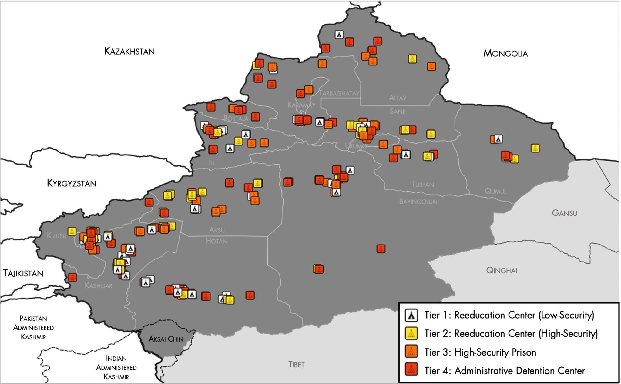
English: Map of the Xinjiang Internment Camps created by the RAND Corporation based on data collected by the US National Geospatial Intelligence Agency and the Australian Strategic Policy Institute. Open source here. |
||||||||
| Dáta | |||||||||
| Foinse | https://www.tearline.mil/public_page/xinjiang-nighttime-1/ | ||||||||
| Údar | National Geospatial Intelligence Agency, using data from the Australian Strategic Policy Institute, and administrative boundaries from GADM. | ||||||||
| Ceadúnas (Athúsáid a bhaint as an gcomhad seo) |
|


Stair chomhaid
Cliceáil ar dáta/am chun an comhad a radharc mar a bhí sé ag an am sin.
| Dáta/Am | Mionsamhail | Toisí | Úsáideoir | Nóta tráchta | |
|---|---|---|---|---|---|
| faoi láthair | 05:05, 2 Bealtaine 2021 | | 2,048 × 1,267 (150 KB) | Abovfold | Uploaded a work by {{w|National Geospatial Intelligence Agency}}, using data from the {{w|Australian Strategic Policy Institute}}, and administrative boundaries from {{w|GADM}}. from https://www.tearline.mil/public_page/xinjiang-nighttime-1/ with UploadWizard |
Úsáid comhaid
Tá nasc chuig an gcomhad seo ar na leathanaigh seo a leanas:
Global file usage
The following other wikis use this file:
- Úsáid ar ba.wikipedia.org
- Úsáid ar br.wikipedia.org
- Úsáid ar cs.wikipedia.org
- Úsáid ar de.wikipedia.org
- Úsáid ar el.wikipedia.org
- Úsáid ar en.wikipedia.org
- Úsáid ar es.wikipedia.org
- Úsáid ar fi.wikipedia.org
- Úsáid ar fr.wikipedia.org
- Úsáid ar he.wikipedia.org
- Úsáid ar km.wikipedia.org
- Úsáid ar nl.wikipedia.org
- Úsáid ar or.wikipedia.org
- Úsáid ar pl.wikipedia.org
- Úsáid ar pt.wikipedia.org
- Úsáid ar ru.wikinews.org
- Úsáid ar sv.wikipedia.org
- Úsáid ar szl.wikipedia.org
- Úsáid ar tr.wikipedia.org
- Úsáid ar www.wikidata.org