
Íomhá:View from Crookston Castle - ENE - geograph.org.uk - 1084296.jpg
Níl aon taifeach is mó ar fáil.
View_from_Crookston_Castle_-_ENE_-_geograph.org.uk_-_1084296.jpg (640 × 320 picteilín, méid comhaid: 56 KB, cineál MIME: image/jpeg)
| Seo comhad as An Cómhaoin Viciméid. Tá an tuairisc as an leathanach tuairisc Cómhaoin a leanas thíos.
|
Achoimriú
| Tuairisc |
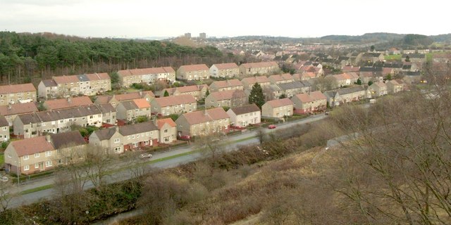
English: View from Crookston Castle - ENE The viewpoint for this picture was the top of Crookston Castle, and the view is towards the Pollok and Corkerhill areas of Glasgow.
The main road visible at the bottom of the image is Lyoncross Road; between this road and the unseen Potterhill Road (higher up the slope) are two rows of houses. Between Potterhill Road and Barnbeth Road (higher up again) are another two rows of houses. There are no houses on the far side of Barnbeth Road, but Crookston Wood begins there; this wood can be seen in the photo. |
| Dáta | |
| Foinse | From geograph.org.uk |
| Údar | Lairich Rig |
| Creidiúint (required by the license) | Lairich Rig / View from Crookston Castle - ENE / |
| Camera location | | View this and other nearby images on: OpenStreetMap |
|---|
_heading:67.00&language=ga)
| Object location | | View this and other nearby images on: OpenStreetMap |
|---|
_heading:67.00&language=ga)
Ceadúnú

|
This image was taken from the Geograph project collection. See this photograph's page on the Geograph website for the photographer's contact details. The copyright on this image is owned by Lairich Rig and is licensed for reuse under the Creative Commons Attribution-ShareAlike 2.0 license.
|
This file is licensed under the Creative Commons Attribution-Share Alike 2.0 Generic license.
Creidiúint: Lairich Rig
- Is féidir:
- an saothar seo a roinnt – an saothar seo a chóipeáil, a dháil amach, agus a tharchur
- an saothar seo a athmheascadh – an saothar seo a oiriúnú
- Ach amháin má leantar na coinníollacha seo a leanas:
- sannadh – Ní mor creidiúint a thabhairt leis an saothar, faoi mar a shonraigh an údar nó tabharthóir an ceadúnais (ach ná húsáid modh a thugann le fios go thacaíonn sé/sí tú féin nó an úsáid a bhaineann tú as an saothar).
- comhroinn araon – Má athraíonn tú nó síneann tú amach an saothar seo, ní féidir é a dháileadh ach amhaín faoin gceadúnas céanna nó ceann cosúil leis an gceann seo.
Stair chomhaid
Cliceáil ar dáta/am chun an comhad a radharc mar a bhí sé ag an am sin.
| Dáta/Am | Mionsamhail | Toisí | Úsáideoir | Nóta tráchta | |
|---|---|---|---|---|---|
| faoi láthair | 12:25, 24 Feabhra 2011 | | 640 × 320 (56 KB) | GeographBot | == {{int:filedesc}} == {{Information |description={{en|1=View from Crookston Castle - ENE The viewpoint for this picture was the top of Crookston Castle, and the view is towards the Pollok and Corkerhill areas of Glasgow. The main road visible at the b |
Úsáid comhaid
Tá nasc chuig an gcomhad seo ar na leathanaigh seo a leanas:
Global file usage
The following other wikis use this file: