
Íomhá:VietnameseProvincesMapTiengViet1.png
Size of this preview: 360 × 600 picteilín. Other resolutions: 144 × 240 picteilín | 428 × 713 picteilín.
Taispeáin leagan ardtaifigh den íomhá (428 × 713 picteilín, méid comhaid: 39 KB, cineál MIME: image/png)
| Seo comhad as An Cómhaoin Viciméid. Tá an tuairisc as an leathanach tuairisc Cómhaoin a leanas thíos.
|
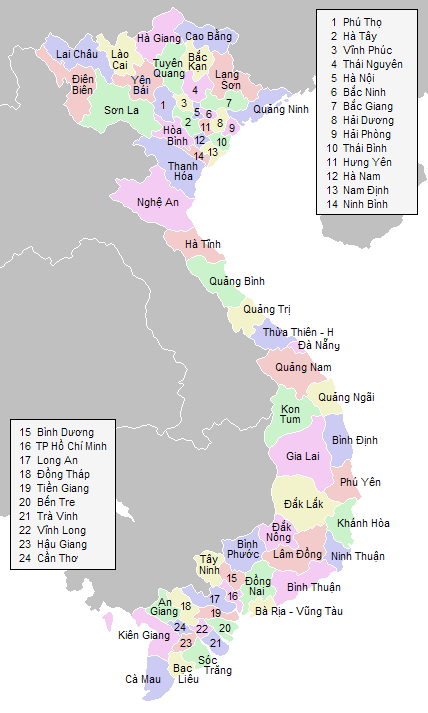
Eđited by Vietlong for the border between provinces of Lai Chau and Lao Cai.
Labeled map of Vietnamese provinces. Made for Wikipedia by uploader.

|
Tugtar cead an doiciméad seo a chóipeáil, a dháileadh agus/nó a mhodhnú faoi théarmaí an Ceadúnas Doiciméadúcháin Saor ó GNU, Leagan 1.2 nó aon leagan níos déanaí a d’fhoilsigh an Fondúireacht Bogearraí Saor in Aisce; gan aon Rannóga Inmheánacha, gan aon Téacsanna Clúdaigh Tosaigh, agus gan aon Téacsanna Clúdaigh Cúil. Tá cóip den cheadúnas san áireamh sa chuid dar teideal Ceadúnas Doiciméadúcháin Saor ó GNU. |
| This file is licensed under the Creative Commons Attribution-Share Alike 3.0 Unported license. | ||
| ||
| This licensing tag was added to this file as part of the GFDL licensing update. |
vi:Hình:VietnameseProvincesMapTiengViet.png
Stair chomhaid
Cliceáil ar dáta/am chun an comhad a radharc mar a bhí sé ag an am sin.
| Dáta/Am | Mionsamhail | Toisí | Úsáideoir | Nóta tráchta | |
|---|---|---|---|---|---|
| faoi láthair | 10:56, 30 Lúnasa 2006 | | 428 × 713 (39 KB) | Vietlong | Labeled map of Vietnamese provinces. Made for Wikipedia by uploader. {{GFDL}} Eđited by Vietlong for the border between provinces of Lai Chau and Lao Cai. vi:Hình:VietnameseProvincesMapTiengViet.png Category:Maps of Vietnam |
Úsáid comhaid
Tá nasc chuig an gcomhad seo ar na leathanaigh seo a leanas:
Global file usage
The following other wikis use this file:
- Úsáid ar ca.wikipedia.org
- Úsáid ar de.wikipedia.org
- Úsáid ar en.wikipedia.org
- Úsáid ar fr.wikipedia.org
- Úsáid ar gl.wikipedia.org
- Úsáid ar ja.wikipedia.org
- Úsáid ar ko.wikipedia.org
- Úsáid ar nl.wikipedia.org
- Úsáid ar vi.wikipedia.org
- Úsáid ar www.wikidata.org
- Úsáid ar zh.wikipedia.org