
Íomhá:Verbreitungsgebiet der heutigen niederdeutschen Mundarten.svg

Size of this PNG preview of this SVG file: 555 × 599 picteilín. Other resolutions: 222 × 240 picteilín | 444 × 480 picteilín | 711 × 768 picteilín | 948 × 1,024 picteilín | 1,897 × 2,048 picteilín | 789 × 852 picteilín.
Taispeáin leagan ardtaifigh den íomhá (Comhad SVG, ainmniúil 789 × 852 picteilíni, méid comhaid: 289 KB)
| Seo comhad as An Cómhaoin Viciméid. Tá an tuairisc as an leathanach tuairisc Cómhaoin a leanas thíos.
|
Achoimriú
| Tuairisc |
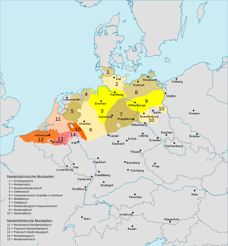
Deutsch: Darstellungskarte der niederdeutschen Mundarten seit 1945
English: Distribution map of the Low Saxon and Low Franconian languages since 1945. Note however that it's bad: "Niedersächsische Mundarten [Low Saxon dialects]: ... 4 = Ostfriesisch [East Frisian] 5 Niedersächsische Dialekte in den Niederlanden [Low Saxon dialects in the Netherlands]" – Parts of what's labelled East Frisian are in the North-East of the Netherlands. Und auch: “niederrheinisch” statt “niederreihnisch” (n°15). |
| Dáta | (UTC) |
| Foinse | |
| Údar |
|
| Leaganacha eile |
Englisch / English:  |


Ceadúnú
Is mise sealbhóir cóipchirt an shaothair seo agus foilsím é faoin gceadúnas seo a leanas:
This file is licensed under the Creative Commons Attribution-Share Alike 3.0 Unported license.
- Is féidir:
- an saothar seo a roinnt – an saothar seo a chóipeáil, a dháil amach, agus a tharchur
- an saothar seo a athmheascadh – an saothar seo a oiriúnú
- Ach amháin má leantar na coinníollacha seo a leanas:
- sannadh – Ní mor creidiúint a thabhairt leis an saothar, faoi mar a shonraigh an údar nó tabharthóir an ceadúnais (ach ná húsáid modh a thugann le fios go thacaíonn sé/sí tú féin nó an úsáid a bhaineann tú as an saothar).
- comhroinn araon – Má athraíonn tú nó síneann tú amach an saothar seo, ní féidir é a dháileadh ach amhaín faoin gceadúnas céanna nó ceann cosúil leis an gceann seo.
Original upload log
This image is a derivative work of the following images:
- File:Verbreitungsgebiet_der_heutigen_niederdeutschen_Mundarten.PNG licensed with PD-user-de, PD-user-w
- 2008-08-08T10:33:32Z Gruna 1 652x652 (37059 Bytes) See previous version
- 2006-04-14T17:48:45Z Vonvon 652x652 (36806 Bytes) * created on de.wikipedia.org by [[:de:Benutzer:Postmann Michael]] on 31 December 2004 * Beschreibung:Darstellungskarte der niederdeutschen Mundarten seit 1945 (''Location Map of the Low Germanic languages'') * original licen
- File:Europe.svg licensed with PD-USGov-CIA-WF
Uploaded with derivativeFX
Stair chomhaid
Cliceáil ar dáta/am chun an comhad a radharc mar a bhí sé ag an am sin.
| Dáta/Am | Mionsamhail | Toisí | Úsáideoir | Nóta tráchta | |
|---|---|---|---|---|---|
| faoi láthair | 18:29, 7 Lúnasa 2022 | | 789 × 852 (289 KB) | Mc zelani | Reverted to version as of 14:40, 7 February 2011 (UTC) |
| 18:50, 12 Nollaig 2017 |  | 700 × 650 (247 KB) | Alphathon | Korrekturen | |
| 17:04, 11 Nollaig 2017 |  | 700 × 650 (280 KB) | Alphathon | Reverted to version as of 22:05, 27 October 2015 (UTC) Uploaded wrong language version | |
| 17:02, 11 Nollaig 2017 |  | 700 × 650 (245 KB) | Alphathon | Correction (Holland → the Netherlands) | |
| 22:05, 27 Deireadh Fómhair 2015 |  | 700 × 650 (280 KB) | Alphathon | Cropped and corrected an error (Vistula Lagoon) | |
| 15:35, 27 Aibreán 2015 |  | 789 × 852 (289 KB) | Groupsixty | verschiedene Schreibfehler korrigiert | |
| 14:40, 7 Feabhra 2011 |  | 789 × 852 (289 KB) | Alphathon | {{Information |Description={{de|Darstellungskarte der niederdeutschen Mundarten seit 1945}} {{en|Distribution map of the Low Saxon and Low Franconian languages since 1945}} |Source=*[[:File:Verbreitungsgebiet_der_heutigen_niederdeutschen_Mundarten.PNG|Ver |
Úsáid comhaid
Tá nasc chuig an gcomhad seo ar na leathanaigh seo a leanas:
Global file usage
The following other wikis use this file:
- Úsáid ar af.wikipedia.org
- Úsáid ar als.wikipedia.org
- Úsáid ar an.wikipedia.org
- Úsáid ar az.wikipedia.org
- Úsáid ar ba.wikipedia.org
- Úsáid ar be.wikipedia.org
- Úsáid ar bg.wikipedia.org
- Úsáid ar ca.wikipedia.org
- Úsáid ar ca.wiktionary.org
- Úsáid ar cv.wikipedia.org
- Úsáid ar de.wikipedia.org
- Úsáid ar de.wiktionary.org
- Úsáid ar es.wikipedia.org
- Úsáid ar fr.wikipedia.org
- Úsáid ar hak.wikipedia.org
- Úsáid ar hr.wikipedia.org
- Úsáid ar it.wikipedia.org
- Úsáid ar ja.wikipedia.org
- Úsáid ar li.wikipedia.org
- Úsáid ar lmo.wikipedia.org
- Úsáid ar nds.wikipedia.org
- Úsáid ar nl.wikipedia.org
- Úsáid ar no.wikipedia.org
- Úsáid ar oc.wikipedia.org
- Úsáid ar pdc.wikipedia.org
- Úsáid ar ro.wikipedia.org
- Úsáid ar ru.wikipedia.org
- Úsáid ar ru.wikiversity.org
- Úsáid ar sc.wikipedia.org
- Úsáid ar sh.wikipedia.org
View more global usage of this file.