
Íomhá:Vatican City map EN.png

Size of this preview: 777 × 600 picteilín. Other resolutions: 311 × 240 picteilín | 622 × 480 picteilín | 995 × 768 picteilín | 1,280 × 988 picteilín | 2,560 × 1,977 picteilín | 2,888 × 2,230 picteilín.
Taispeáin leagan ardtaifigh den íomhá (2,888 × 2,230 picteilín, méid comhaid: 2.41 MB, cineál MIME: image/png)
| Seo comhad as An Cómhaoin Viciméid. Tá an tuairisc as an leathanach tuairisc Cómhaoin a leanas thíos.
|
Achoimriú
| Cur síos |
Deutsch: Karte der Vatikanstadt (englische Version)
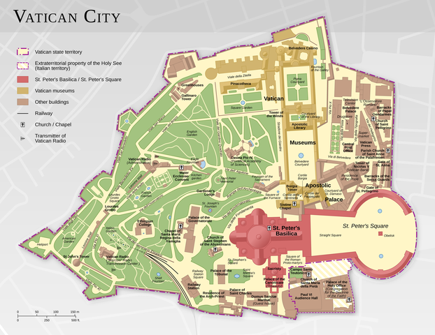
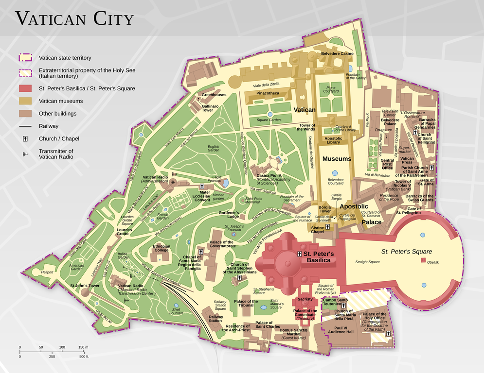
English: Map of the Vatican City (English version)
Español: Mapa de la Ciudad del Vaticano (versión en inglés).
Suomi: Vatikaanin kartta (englanninkielinen versio)
Français : Carte de la Cité du Vatican, à partir d'informations d'OpenStreetMap. Version en anglais ; voir la version en français ici : Vatican City map FR.png
中文:梵蒂冈城国地图(英语版本)
Bosanski: Karta Vatikana - sadrži kartografske podatke sa projekta ©OpenStreetMap (ODbL).
|
|||||||||
| Dáta | ||||||||||
| Foinse |
Obair féin |
|||||||||
| Cruthaitheoir | ||||||||||
| Ceadúnas (Athúsáid a bhaint as an gcomhad seo) |
|
|||||||||
| Geotemporal data | ||||||||||
| Bounding box |
|
|||||||||
| Georeferencing | ||||||||||
| Leaganacha eile |
|
|||||||||


|
This map has been made or improved in the German Kartenwerkstatt (Map Lab). You can propose maps to improve as well.
|
Ceadúnú
This file is licensed under the Creative Commons Attribution-Share Alike 3.0 Unported license.
Creidiúint: Thomas Römer/OpenStreetMap data
- Is féidir:
- an saothar seo a roinnt – an saothar seo a chóipeáil, a dháil amach, agus a tharchur
- an saothar seo a athmheascadh – an saothar seo a oiriúnú
- Ach amháin má leantar na coinníollacha seo a leanas:
- sannadh – Ní mor creidiúint a thabhairt leis an saothar, faoi mar a shonraigh an údar nó tabharthóir an ceadúnais (ach ná húsáid modh a thugann le fios go thacaíonn sé/sí tú féin nó an úsáid a bhaineann tú as an saothar).
- comhroinn araon – Má athraíonn tú nó síneann tú amach an saothar seo, ní féidir é a dháileadh ach amhaín faoin gceadúnas céanna nó ceann cosúil leis an gceann seo.
Assessment
|

Roghnaíodh an íomhá seo mar íomhá an lae ar 11 février 2015. An fotheideal a bhí mar seo a leanas: Teangacha eile:
Bosanski: Karta Vatikana - sadrži kartografske podatke sa projekta ©OpenStreetMap (ODbL). |
Stair chomhaid
Cliceáil ar dáta/am chun an comhad a radharc mar a bhí sé ag an am sin.
| Dáta/Am | Mionsamhail | Toisí | Úsáideoir | Nóta tráchta | |
|---|---|---|---|---|---|
| faoi láthair | 11:44, 12 Feabhra 2021 | | 2,888 × 2,230 (2.41 MB) | Foghe | St. Damasco → St. Damaso. |
| 09:22, 11 Aibreán 2013 |  | 2,888 × 2,230 (2.14 MB) | Thoroe | larger render | |
| 17:12, 10 Aibreán 2013 |  | 1,733 × 1,338 (1.11 MB) | Thoroe | small fixes | |
| 15:59, 23 Márta 2013 |  | 1,733 × 1,338 (1.1 MB) | Thoroe | minor fixes | |
| 00:41, 23 Márta 2013 |  | 1,733 × 1,338 (1.09 MB) | Thoroe | {{Information |Description ={{en|1=Map of the Vatican City (English version)}} {{de|1=Karte der Vatikanstadt (englische Version)}} |Source ={{own}} *[http://www.vatican.va/news_services/press/docume... |
Úsáid comhaid
Níl nasc ó aon leathanach eile don íomhá seo.
Global file usage
The following other wikis use this file:
- Úsáid ar af.wikipedia.org
- Úsáid ar be-tarask.wikipedia.org
- Úsáid ar ca.wikipedia.org
- Úsáid ar crh.wikipedia.org
- Úsáid ar cv.wikipedia.org
- Úsáid ar de.wikipedia.org
- Úsáid ar en.wikipedia.org
- Portal:Geography
- Wikipedia:Featured pictures/Diagrams, drawings, and maps/Maps
- Talk:Vatican City/Archive 1
- User talk:Thoroe
- Wikipedia:Featured pictures thumbs/37
- User talk:Crisco 1492/Archive 44
- Wikipedia:Featured picture candidates/Vatican City map
- Wikipedia:Featured picture candidates/October-2013
- Wikipedia:Picture of the day/August 2015
- Template:POTD/2015-08-07
- Wikipedia:Main Page history/2015 August 7
- User:John Paul II/Line of Popes
- Portal:Geography/Selected picture
- User:ਕਰਨ 13/sandbox
- Úsáid ar en.wikivoyage.org
- Úsáid ar fo.wikipedia.org
- Úsáid ar fr.wikipedia.org
- Úsáid ar hu.wikipedia.org
- Úsáid ar ka.wikipedia.org
- Úsáid ar ko.wikipedia.org
- Úsáid ar krc.wikipedia.org
- Úsáid ar lbe.wikipedia.org
- Úsáid ar www.mediawiki.org
- Úsáid ar mg.wikipedia.org
- Úsáid ar os.wikipedia.org
- Úsáid ar pl.wikipedia.org
- Úsáid ar pt.wikipedia.org
- Úsáid ar ru.wikipedia.org
- Úsáid ar ru.wikinews.org
- Úsáid ar sah.wikipedia.org
- Úsáid ar sv.wikipedia.org
- Úsáid ar tr.wikipedia.org
View more global usage of this file.