
Íomhá:Topographic map of Saint Helena-fr.svg

Size of this PNG preview of this SVG file: 740 × 600 picteilín. Other resolutions: 296 × 240 picteilín | 592 × 480 picteilín | 948 × 768 picteilín | 1,264 × 1,024 picteilín | 2,527 × 2,048 picteilín | 802 × 650 picteilín.
Taispeáin leagan ardtaifigh den íomhá (Comhad SVG, ainmniúil 802 × 650 picteilíni, méid comhaid: 595 KB)
| Seo comhad as An Cómhaoin Viciméid. Tá an tuairisc as an leathanach tuairisc Cómhaoin a leanas thíos.
|
| Tuairisc |
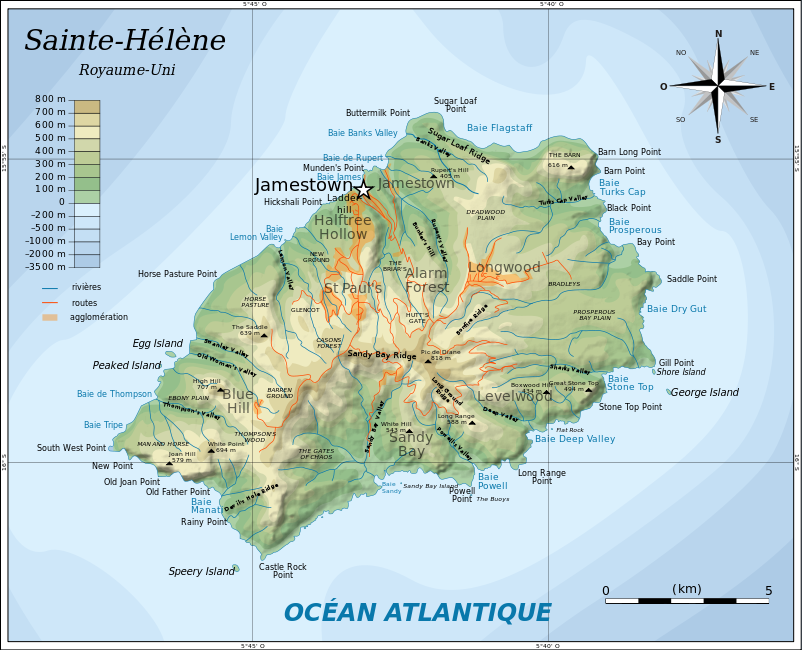
English: Topographic map of the British island of Saint Helena.
Français : Carte topographique de l'île britannique de Sainte-Hélène. |
| Dáta | (UTC) |
| Foinse | |
| Údar |
|
| This is a retouched picture, which means that it has been digitally altered from its original version. Modifications: traduction. The original can be viewed here: Topographic map of Saint Helena-en.svg:
|
Is mise sealbhóir cóipchirt an shaothair seo agus foilsím é faoi na ceadúnais seo a leanas:
This file is licensed under the Creative Commons Attribution-Share Alike 3.0 Unported license.
- Is féidir:
- an saothar seo a roinnt – an saothar seo a chóipeáil, a dháil amach, agus a tharchur
- an saothar seo a athmheascadh – an saothar seo a oiriúnú
- Ach amháin má leantar na coinníollacha seo a leanas:
- sannadh – Ní mor creidiúint a thabhairt leis an saothar, faoi mar a shonraigh an údar nó tabharthóir an ceadúnais (ach ná húsáid modh a thugann le fios go thacaíonn sé/sí tú féin nó an úsáid a bhaineann tú as an saothar).
- comhroinn araon – Má athraíonn tú nó síneann tú amach an saothar seo, ní féidir é a dháileadh ach amhaín faoin gceadúnas céanna nó ceann cosúil leis an gceann seo.

|
Tugtar cead an doiciméad seo a chóipeáil, a dháileadh agus/nó a mhodhnú faoi théarmaí an Ceadúnas Doiciméadúcháin Saor ó GNU, Leagan 1.2 nó aon leagan níos déanaí a d’fhoilsigh an Fondúireacht Bogearraí Saor in Aisce; gan aon Rannóga Inmheánacha, gan aon Téacsanna Clúdaigh Tosaigh, agus gan aon Téacsanna Clúdaigh Cúil. Tá cóip den cheadúnas san áireamh sa chuid dar teideal Ceadúnas Doiciméadúcháin Saor ó GNU. |
Is féidir leat a roghnú an ceadúnas do rogha
Original upload log
This image is a derivative work of the following images:
- File:Topographic_map_of_Saint_Helena-en.svg licensed with Cc-by-sa-3.0, GFDL
- 2010-08-10T05:54:46Z Mysid 802x650 (596823 Bytes) legend for roads, rivers, agglomeration
- 2010-08-09T21:42:54Z Mysid 802x650 (594310 Bytes) bugfix #2
- 2010-08-09T21:40:19Z Mysid 802x650 (266379 Bytes) bugfix
- 2010-08-09T21:27:26Z Mysid 647x594 (592648 Bytes) {{Information |Description={{en|1=Topographic map of the British island of [[w:Saint Helena|]].}} |Source=Self-made in Inkscape. Based on several sources. |Author=[[w:User:Mysid|Mysid]] |Date=2010-08-10 |Permission= |other_ve
Uploaded with derivativeFX
Stair chomhaid
Cliceáil ar dáta/am chun an comhad a radharc mar a bhí sé ag an am sin.
| Dáta/Am | Mionsamhail | Toisí | Úsáideoir | Nóta tráchta | |
|---|---|---|---|---|---|
| faoi láthair | 14:22, 17 Deireadh Fómhair 2010 | | 802 × 650 (595 KB) | Treehill | correction noms |
| 19:43, 15 Deireadh Fómhair 2010 |  | 802 × 650 (592 KB) | Treehill | traduction de Diane's Peak en Pic de Diane ([http://www.lautresaintehelene.com/autre-sainte-helene-lieux-ile.html rencontré ici]). | |
| 19:31, 15 Deireadh Fómhair 2010 |  | 802 × 650 (591 KB) | Treehill | {{Information |Description={{en|1=Topographic map of the British island of Saint Helena.}} {{fr|1=Carte topographique de l'île britannique de Sainte-Hélène.}} |Source=*[[:File:Topographic_map_of_Saint_Helena-en |
Úsáid comhaid
Tá nasc chuig an gcomhad seo ar na leathanaigh seo a leanas:
Global file usage
The following other wikis use this file:
- Úsáid ar ca.wikipedia.org
- Úsáid ar fr.wikipedia.org
- Úsáid ar fr.wikivoyage.org
- Úsáid ar gl.wikipedia.org
- Úsáid ar lb.wikipedia.org
- Úsáid ar www.wikidata.org