
Íomhá:Tectonic plate boundaries.png
Níl aon taifeach is mó ar fáil.
Tectonic_plate_boundaries.png (775 × 429 picteilín, méid comhaid: 83 KB, cineál MIME: image/png)
| Seo comhad as An Cómhaoin Viciméid. Tá an tuairisc as an leathanach tuairisc Cómhaoin a leanas thíos.
|
Achoimriú
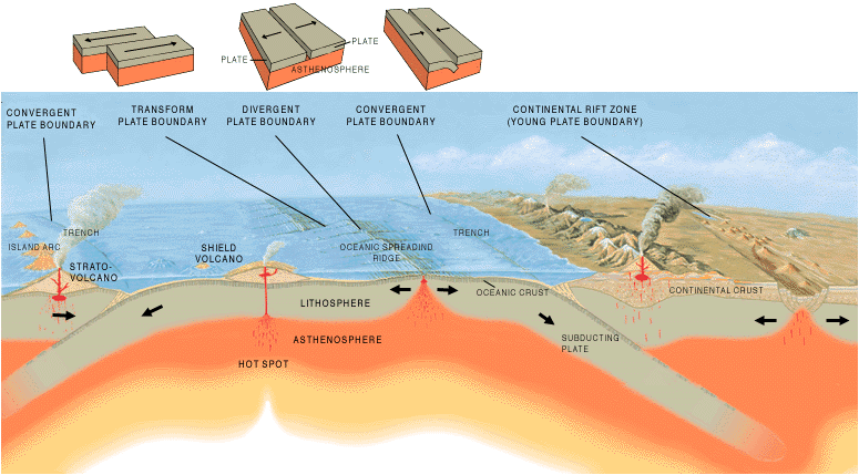
| Tuairisc | A cross section illustrating the main types of plate boundaries. |
| Dáta | |
| Foinse | [1] |
| Údar | Jose F. Vigil. USGS |
| Leaganacha eile |
Slovenian translation, Spanish version
[]
|


Ceadúnú
This image is in the public domain in the United States because it only contains materials that originally came from the United States Geological Survey, an agency of the United States Department of the Interior. For more information, see the official USGS copyright policy.
|
Stair chomhaid
Cliceáil ar dáta/am chun an comhad a radharc mar a bhí sé ag an am sin.
| Dáta/Am | Mionsamhail | Toisí | Úsáideoir | Nóta tráchta | |
|---|---|---|---|---|---|
| faoi láthair | 15:40, 26 Nollaig 2005 | | 775 × 429 (83 KB) | Merikanto~commonswiki | Illustration by Jose F. Vigil. USGS. [http://pubs.usgs.gov/gip/earthq1/plate.html] {{PD-USGov-Interior-USGS}} |
Úsáid comhaid
Tá nasc chuig an gcomhad seo ar na leathanaigh seo a leanas:
Global file usage
The following other wikis use this file:
- Úsáid ar ar.wikipedia.org
- Úsáid ar as.wikipedia.org
- Úsáid ar az.wikipedia.org
- Úsáid ar ba.wikipedia.org
- Úsáid ar bg.wikipedia.org
- Úsáid ar bs.wikipedia.org
- Úsáid ar da.wikipedia.org
- Úsáid ar de.wikipedia.org
- Úsáid ar en.wikipedia.org
- Úsáid ar en.wikibooks.org
- Úsáid ar eo.wikipedia.org
- Úsáid ar es.wikipedia.org
- Úsáid ar eu.wikipedia.org
- Úsáid ar fa.wikipedia.org
- Úsáid ar fi.wikipedia.org
- Úsáid ar fr.wikipedia.org
- Úsáid ar he.wikipedia.org
- Úsáid ar hi.wikipedia.org
- Úsáid ar hu.wikipedia.org
- Úsáid ar hy.wikipedia.org
- Úsáid ar hyw.wikipedia.org
- Úsáid ar id.wikipedia.org
- Úsáid ar it.wikipedia.org
- Úsáid ar it.wikibooks.org
- Úsáid ar it.wikiversity.org
- Úsáid ar ja.wikipedia.org
- Úsáid ar ka.wikipedia.org
- Úsáid ar kn.wikipedia.org
- Úsáid ar ko.wikipedia.org
View more global usage of this file.