
Íomhá:Sy-map.png
Níl aon taifeach is mó ar fáil.
Sy-map.png (326 × 350 picteilín, méid comhaid: 11 KB, cineál MIME: image/png)
| Seo comhad as An Cómhaoin Viciméid. Tá an tuairisc as an leathanach tuairisc Cómhaoin a leanas thíos.
|

|
This locator map image could be re-created using vector graphics as an SVG file. This has several advantages; see Commons:Media for cleanup for more information. If an SVG form of this image is available, please upload it and afterwards replace this template with
{{vector version available|new image name}}.
It is recommended to name the SVG file “Sy-map.svg”—then the template Vector version available (or Vva) does not need the new image name parameter. |
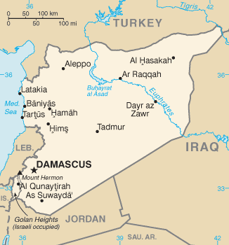
CIA map of Syria
This image is in the public domain because it contains materials that originally came from the United States Central Intelligence Agency's World Factbook.
|
 |
Stair chomhaid
Cliceáil ar dáta/am chun an comhad a radharc mar a bhí sé ag an am sin.
| Dáta/Am | Mionsamhail | Toisí | Úsáideoir | Nóta tráchta | |
|---|---|---|---|---|---|
| faoi láthair | 13:04, 14 Eanáir 2011 | | 326 × 350 (11 KB) | Ras67 | cropped |
| 07:59, 11 Eanáir 2009 |  | 328 × 353 (12 KB) | Timeshifter | Latest version of the map from the CIA Factbook page for Syria. That page was last updated Dec. 18, 2008. I converted the GIF image to PNG using the freeware IrfanView PNGOUT to losslessly compress the image to palette PNG. | |
| 13:35, 12 Bealtaine 2005 |  | 328 × 352 (12 KB) | Eirik | CIA map of syria {{PD-USGov-CIA-WF}} Category:Maps of Syria |
Úsáid comhaid
Níl nasc ó aon leathanach eile don íomhá seo.
Global file usage
The following other wikis use this file:
- Úsáid ar ace.wikipedia.org
- Úsáid ar ar.wikipedia.org
- Úsáid ar azb.wikipedia.org
- Úsáid ar be-tarask.wikipedia.org
- Úsáid ar bg.wikipedia.org
- Úsáid ar bg.wiktionary.org
- Úsáid ar br.wikipedia.org
- Úsáid ar ca.wikipedia.org
- Úsáid ar ca.wikinews.org
- Úsáid ar da.wikipedia.org
- Úsáid ar de.wikipedia.org
- Úsáid ar de.wikinews.org
- Úsáid ar diq.wikipedia.org
- Úsáid ar dsb.wikipedia.org
- Úsáid ar el.wikipedia.org
- Úsáid ar el.wikinews.org
- Úsáid ar en.wikipedia.org
- Úsáid ar en.wikinews.org
- Úsáid ar en.wikiquote.org
- Úsáid ar en.wiktionary.org
- Úsáid ar eo.wikipedia.org
- Úsáid ar fi.wikipedia.org
- Úsáid ar fr.wikipedia.org
- Úsáid ar fr.wikinews.org
- Úsáid ar gl.wikipedia.org
- Úsáid ar gu.wikipedia.org
- Úsáid ar hif.wikipedia.org
- Úsáid ar hi.wikipedia.org
- Úsáid ar hi.wiktionary.org
- Úsáid ar id.wikipedia.org
- Úsáid ar incubator.wikimedia.org
- Úsáid ar ja.wikipedia.org
- Úsáid ar jv.wikipedia.org
- Úsáid ar ko.wiktionary.org
- Úsáid ar mai.wikipedia.org
- Úsáid ar mr.wikipedia.org
View more global usage of this file.