
Íomhá:Spread of Christianity to AD 600 - Atlas of World History.png

Size of this preview: 800 × 592 picteilín. Other resolutions: 320 × 237 picteilín | 640 × 474 picteilín | 1,024 × 758 picteilín | 1,280 × 948 picteilín | 2,187 × 1,619 picteilín.
Taispeáin leagan ardtaifigh den íomhá (2,187 × 1,619 picteilín, méid comhaid: 227 KB, cineál MIME: image/png)
| Seo comhad as An Cómhaoin Viciméid. Tá an tuairisc as an leathanach tuairisc Cómhaoin a leanas thíos.
|
Achoimriú
| Tuairisc |
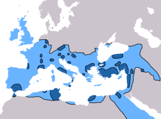
English: Map of the spread of Christianity in Europe, Southwest Asia and North Africa to the year AD 600.
"redominantly Christian by AD 325" zone coloured in dark blue, "Predominantly Christian by AD 600" coloured in light blue.
Predominantly Christian by AD 325
Predominantly Christian by AD 600
Magyar: A kereszténység elterjedése:
Kr. u. 325-ig
325 és 600 között
Information obtained from Patrick O'Brien , ed. (2003) Atlas of World History, Category:New York: Oxford University Press, pp. 44−5 0-19-521921-X Map created and uploaded in the English Wikipedia by Geuiwogbil. Base map: "File:BlankMap-Europe-v3.png" |
| Dáta | 27 Bealtaine 2009 (original upload date) |
| Foinse | Transferred from en.wikipedia to Commons by QuartierLatin1968 using CommonsHelper. |
| Údar | Geuiwogbil ar an Vicipéid Béarla |

|
This religion map image could be re-created using vector graphics as an SVG file. This has several advantages; see Commons:Media for cleanup for more information. If an SVG form of this image is available, please upload it and afterwards replace this template with
{{vector version available|new image name}}.
It is recommended to name the SVG file “Spread of Christianity to AD 600 - Atlas of World History.svg”—then the template Vector version available (or Vva) does not need the new image name parameter. |
Ceadúnú
Is mise Geuiwogbil from en.wikipedia.org, sealbhóir cóipchirt an shaothair seo, agus foilsím é faoi na ceadúnais seo a leanas:
| This file is licensed under the Creative Commons Attribution-Share Alike 3.0 Unported license. Faoi réir ag séanaidh ginearálta. | ||
| Creidiúint: Geuiwogbil from en.wikipedia.org | ||
| ||
| This licensing tag was added to this file as part of the GFDL licensing update. |

|
Tugtar cead an doiciméad seo a chóipeáil, a dháileadh agus/nó a mhodhnú faoi théarmaí an Ceadúnas Doiciméadúcháin Saor ó GNU, Leagan 1.2 nó aon leagan níos déanaí a d’fhoilsigh an Fondúireacht Bogearraí Saor in Aisce; gan aon Rannóga Inmheánacha, gan aon Téacsanna Clúdaigh Tosaigh, agus gan aon Téacsanna Clúdaigh Cúil. Tá cóip den cheadúnas san áireamh sa chuid dar teideal Ceadúnas Doiciméadúcháin Saor ó GNU. Faoi réir ag séanaidh ginearálta. |
Original upload log
The original description page was here. All following user names refer to en.wikipedia.
- 2009-05-27 19:20 Carlaude 2187×1619× (232587 bytes) Cutting out unused areas of the map
- 2006-09-09 02:34 Geuiwogbil 2285×2181× (248280 bytes) Blue provides us with a better constrast.
- 2006-09-04 05:10 Geuiwogbil 2285×2181× (254524 bytes)
- 2006-09-04 05:08 Geuiwogbil 2285×2181× (116034 bytes) Map of the spread of Christianity in Europe, Southwest Asia and North Africa to the year 600 AD. Base map "BlankMap-Europe-v.3." Spread of Christianity to AD 325 coloured in orange, to 600 coloured in yellow. Information obtained from {{cite book |editor=
Stair chomhaid
Cliceáil ar dáta/am chun an comhad a radharc mar a bhí sé ag an am sin.
| Dáta/Am | Mionsamhail | Toisí | Úsáideoir | Nóta tráchta | |
|---|---|---|---|---|---|
| faoi láthair | 17:31, 3 Meitheamh 2022 | | 2,187 × 1,619 (227 KB) | Veverve | Reverted to version as of 10:19, 4 July 2021 (UTC) please bring a map source to counter this claim that only part of Armenia etc. were partially christianised |
| 17:08, 3 Meitheamh 2022 |  | 2,187 × 1,619 (245 KB) | Rs4815 | Reverted to version as of 09:58, 24 February 2013 (UTC) You can't just ignore the fact that the "sourced version of the map" has a blunder. By the year 325, the Armenian kingdom had already been converted to Christianity | |
| 10:19, 4 Iúil 2021 |  | 2,187 × 1,619 (227 KB) | Veverve | Reverted to version as of 12:31, 9 November 2009 (UTC) revert to what is an actually sourced version of the map | |
| 06:34, 23 Bealtaine 2018 |  | 2,187 × 1,619 (213 KB) | Inowen | Add labels for Europe, Africa, and Middle East using Inkscape to import previous and overlay text in svg. | |
| 09:58, 24 Feabhra 2013 |  | 2,187 × 1,619 (245 KB) | Prince of Nothing05 | Kingdom of Armenia, Iberia and Caucasian Albania had already made Christianity official religion. | |
| 12:31, 9 Samhain 2009 |  | 2,187 × 1,619 (227 KB) | QuartierLatin1968 | {{Information |Description={{en|Map of the spread of Christianity in Europe, Southwest Asia and North Africa to the year 600 AD. Base map "BlankMap-Europe-v.3." Spread of Christianity to AD 325 coloured in light blue, to 600 coloured in dark blue. Informa |
Úsáid comhaid
Tá nasc chuig an gcomhad seo ar na leathanaigh seo a leanas:
Global file usage
The following other wikis use this file:
- Úsáid ar ar.wikipedia.org
- Úsáid ar arz.wikipedia.org
- Úsáid ar be.wikipedia.org
- Úsáid ar bg.wikipedia.org
- Úsáid ar ca.wikipedia.org
- Úsáid ar cs.wikipedia.org
- Úsáid ar de.wikipedia.org
- Úsáid ar el.wikipedia.org
- Úsáid ar en.wikipedia.org
- Christendom
- Christian Church
- Christianity in Africa
- Talk:Christian Church/Archive 1
- Christianity in the Middle East
- Spread of Christianity
- Multiculturalism and Christianity
- Western world
- Christianity in the ante-Nicene period
- Christianity in the 4th century
- Christianity in the 5th century
- Christianity in the 6th century
- Christianity in the 7th century
- Christianity in late antiquity
- Christianity as the Roman state religion
- Roman people
- User:Falcaorib
- Úsáid ar en.wikibooks.org
- Úsáid ar en.wikiquote.org
- Úsáid ar eo.wikipedia.org
- Úsáid ar es.wikipedia.org
View more global usage of this file.