
Íomhá:Somaliland map.png
Níl aon taifeach is mó ar fáil.
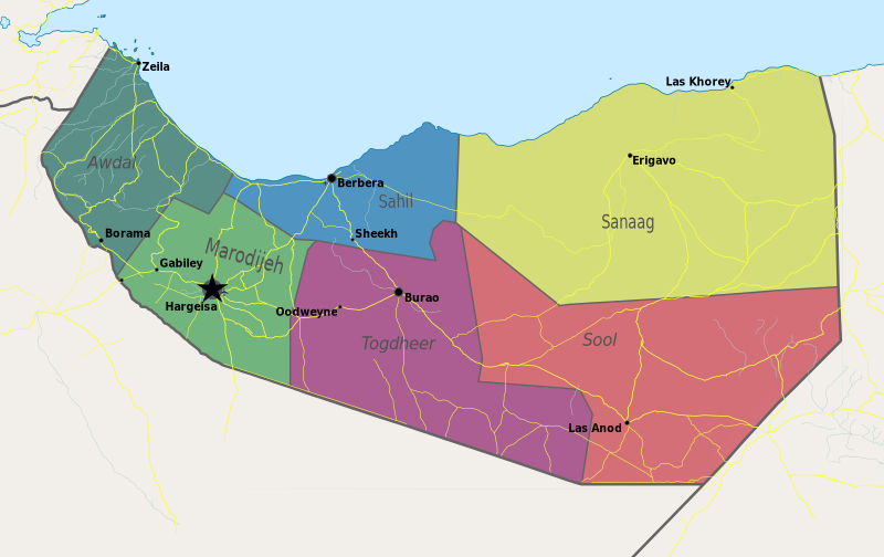
Somaliland_map.png (800 × 504 picteilín, méid comhaid: 99 KB, cineál MIME: image/png)
| Seo comhad as An Cómhaoin Viciméid. Tá an tuairisc as an leathanach tuairisc Cómhaoin a leanas thíos.
|
Achoimriú
| Tuairisc | Map of Somaliland. |
| Dáta | |
| Foinse | Obair féin |
| Údar | PANONIAN |
Ceadúnú
Is mise sealbhóir cóipchirt an shaothair seo agus foilsím é faoin gceadúnas seo a leanas:
| This file is made available under the Creative Commons CC0 1.0 Universal Public Domain Dedication. | |
| The person who associated a work with this deed has dedicated the work to the public domain by waiving all of their rights to the work worldwide under copyright law, including all related and neighboring rights, to the extent allowed by law. You can copy, modify, distribute and perform the work, even for commercial purposes, all without asking permission.
|
References
- http://www.sdo.nu/wp-content/uploads/2010/04/map-vd-steden1.gif
- http://www.somaliland.org/images/i/map_somaliland_org.gif
- http://www.somaliland.org/images/b/2007/11/map_somaliland.gif
- http://images.wikia.com/turtledove/images/c/c7/SomalilandMap.jpg
- http://xarbi.files.wordpress.com/2010/11/somaliland-map-in-ai.jpg
- http://cdn-english.alshahid.net/wp-content/uploads/2010/02/somland.jpg?59dea9
- http://www.tothepointnews.com/images/stories/2011/somaliland_map.jpg
- http://xarbi.files.wordpress.com/2010/04/somaliland-map22.jpg
- http://xarbi.files.wordpress.com/2010/05/somaliland-map-20101.jpg
- http://www.afrol.com/images/maps/somaliland_big.gif
Stair chomhaid
Cliceáil ar dáta/am chun an comhad a radharc mar a bhí sé ag an am sin.
| Dáta/Am | Mionsamhail | Toisí | Úsáideoir | Nóta tráchta | |
|---|---|---|---|---|---|
| faoi láthair | 11:55, 10 Bealtaine 2021 | | 800 × 504 (99 KB) | Siirski | Update |
| 18:04, 20 Meitheamh 2020 |  | 1,254 × 741 (42 KB) | Chipmunkdavis | Reverted to version as of 14:41, 2 July 2012 (UTC) Rv unlablled change. The only labelled place is controlled by Somaliland. | |
| 20:31, 17 Meitheamh 2020 |  | 800 × 473 (64 KB) | Meelpringthusss | clearer color | |
| 02:12, 16 Meitheamh 2020 |  | 800 × 473 (64 KB) | Meelpringthusss | added disputed areas | |
| 14:41, 2 Iúil 2012 |  | 1,254 × 741 (42 KB) | PANONIAN | {{Information |Description=Map of Somaliland. |Source={{own}} |Date=2012 |Author= PANONIAN |Permission= |other_versions= }} |
Úsáid comhaid
Tá nasc chuig an gcomhad seo ar na leathanaigh seo a leanas:
Global file usage
The following other wikis use this file:
- Úsáid ar arz.wikipedia.org
- Úsáid ar be.wikipedia.org
- Úsáid ar bn.wikipedia.org
- Úsáid ar bs.wikipedia.org
- Úsáid ar ca.wikipedia.org
- Úsáid ar crh.wikipedia.org
- Úsáid ar dv.wikipedia.org
- Úsáid ar hr.wikipedia.org
- Úsáid ar hy.wikipedia.org
- Úsáid ar incubator.wikimedia.org
- Úsáid ar ms.wikipedia.org
- Úsáid ar oc.wikipedia.org
- Úsáid ar pam.wikipedia.org
- Úsáid ar pnb.wikipedia.org
- Úsáid ar sa.wikipedia.org
- Úsáid ar sco.wikipedia.org
- Úsáid ar sh.wikipedia.org
- Úsáid ar sk.wikipedia.org
- Úsáid ar so.wikipedia.org
- Úsáid ar sr.wikipedia.org
- Úsáid ar su.wikipedia.org
- Úsáid ar ta.wikipedia.org
- Úsáid ar tl.wikipedia.org
- Úsáid ar tr.wikipedia.org
- Úsáid ar ur.wikipedia.org
- Úsáid ar xmf.wikipedia.org