
Íomhá:Rock of Cashel, Tipperary.jpg
Size of this preview: 800 × 514 picteilín. Other resolutions: 320 × 206 picteilín | 640 × 411 picteilín | 1,024 × 658 picteilín.
Taispeáin leagan ardtaifigh den íomhá (1,024 × 658 picteilín, méid comhaid: 826 KB, cineál MIME: image/jpeg)
| Seo comhad as An Cómhaoin Viciméid. Tá an tuairisc as an leathanach tuairisc Cómhaoin a leanas thíos.
|
| Tuairisc |
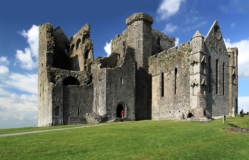
English: Rock of Cashel, Tipperary, Munster, Ireland.
The view is of the cathedral and its attached castle on the Rock of Cashel. From the earliest of times, and before these buildings were erected, what is now the cathedral close was always a fortress. It was then the seat of Brian Boru, crowned High King of Ireland in 977, but in 1101 it was handed over to the church by Muircheartach O'Brien. Violence erupted on the Rock in 1647 when the Rock of Cashel was stormed by Lord Inchiquin's forces. During the conflict twenty clerics who had taken refuge there were killed within the castle, as were all the Irish Confederate troops. |
| Dáta | |
| Foinse | see below |
| Údar | Mike Searle |
| Ceadúnas (Athúsáid a bhaint as an gcomhad seo) |
Creative Commons Attribution Share-alike license 2.0 |
| Creidiúint (required by the license) | Mike Searle / Castles of Munster: Cashel, Rock of Cashel, Tipperary / |
| Camera location | | View this and other nearby images on: OpenStreetMap |
|---|
_&language=ga)
| Object location | | View this and other nearby images on: OpenStreetMap |
|---|
_&language=ga)
Ceadúnú

|
This image was taken from the Geograph project collection. See this photograph's page on the Geograph website for the photographer's contact details. The copyright on this image is owned by Mike Searle and is licensed for reuse under the Creative Commons Attribution-ShareAlike 2.0 license.
|
This file is licensed under the Creative Commons Attribution-Share Alike 2.0 Generic license.
Creidiúint: Mike Searle
- Is féidir:
- an saothar seo a roinnt – an saothar seo a chóipeáil, a dháil amach, agus a tharchur
- an saothar seo a athmheascadh – an saothar seo a oiriúnú
- Ach amháin má leantar na coinníollacha seo a leanas:
- sannadh – Ní mor creidiúint a thabhairt leis an saothar, faoi mar a shonraigh an údar nó tabharthóir an ceadúnais (ach ná húsáid modh a thugann le fios go thacaíonn sé/sí tú féin nó an úsáid a bhaineann tú as an saothar).
- comhroinn araon – Má athraíonn tú nó síneann tú amach an saothar seo, ní féidir é a dháileadh ach amhaín faoin gceadúnas céanna nó ceann cosúil leis an gceann seo.
Stair chomhaid
Cliceáil ar dáta/am chun an comhad a radharc mar a bhí sé ag an am sin.
| Dáta/Am | Mionsamhail | Toisí | Úsáideoir | Nóta tráchta | |
|---|---|---|---|---|---|
| faoi láthair | 18:31, 10 Feabhra 2019 | | 1,024 × 658 (826 KB) | Geograph Update Bot | Higher-resolution version from Geograph. |
| 17:17, 18 Deireadh Fómhair 2009 |  | 640 × 411 (315 KB) | Thomas Gun | {{Information |Description={{en|1=Rock of Cashel, Tipperary, Munster, Ireland.}} |Source=[http://www.geograph.org.uk/photo/1393486 geography.org.uk] |Date=Friday, 26 June, 2009 |Author=[http://www.geograph.org.uk/profile/10423 Mike Searle] |Permission=Cre |
Úsáid comhaid
Tá nasc chuig an gcomhad seo ar 2 an leathanach seo a leanas:
Global file usage
The following other wikis use this file:
- Úsáid ar cs.wikipedia.org
- Úsáid ar de.wikipedia.org
- Úsáid ar de.wikivoyage.org
- Úsáid ar en.wikipedia.org
- Úsáid ar en.wikivoyage.org
- Úsáid ar eo.wikipedia.org
- Úsáid ar es.wikipedia.org
- Úsáid ar eu.wikipedia.org
- Úsáid ar fa.wikipedia.org
- Úsáid ar he.wikipedia.org
- Úsáid ar it.wikipedia.org
- Úsáid ar it.wikivoyage.org
- Úsáid ar ja.wikivoyage.org
- Úsáid ar nl.wikipedia.org
- Úsáid ar no.wikipedia.org
- Úsáid ar uk.wikipedia.org
- Úsáid ar www.wikidata.org