
Íomhá:Public Schools Historical Atlas - Roman Britain 400.jpg

Size of this preview: 458 × 600 picteilín. Other resolutions: 183 × 240 picteilín | 367 × 480 picteilín | 880 × 1,152 picteilín.
Taispeáin leagan ardtaifigh den íomhá (880 × 1,152 picteilín, méid comhaid: 364 KB, cineál MIME: image/jpeg)
| Seo comhad as An Cómhaoin Viciméid. Tá an tuairisc as an leathanach tuairisc Cómhaoin a leanas thíos.
|
Achoimriú
| Tuairisc |
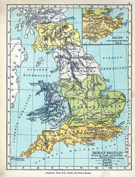
English: Map of Roman Britain in 400. |
| Dáta | |
| Foinse |
|
| Údar |
|
| Leaganacha eile |
|

Ceadúnú
I Stáit Aontaithe Mheiriceá, tá an chomhad méide seo sa bhfearann poiblí. Ciallaíonn sé seo go bhfoilsíodh don chéad uair an íomhá seo i Stáit Aontaithe Meiriceá roimh an 1 Eanáir 1929. Féach ar an leathanach seo le tuilleadh eolais.
|
 | |
 |
B'fhéidir go bhfuil rialacha eile i bhfeidhm i limistéir údaráis eile, agus b'fhéidir nach bhfuil an íomhá seo sa bhfearann poiblí lasmuigh de Stáit Aontaithe Mhericeá.
|
Stair chomhaid
Cliceáil ar dáta/am chun an comhad a radharc mar a bhí sé ag an am sin.
| Dáta/Am | Mionsamhail | Toisí | Úsáideoir | Nóta tráchta | |
|---|---|---|---|---|---|
| faoi láthair | 18:05, 18 Meitheamh 2009 | | 880 × 1,152 (364 KB) | Yarl | == {{int:filedesc}} == {{Information |Description={{en|Map of Roman Britain in 400.}} |Source= * ''The Public Schools Historical Atlas'' by Charles Colbeck. Longmans, Green; New York; London; Bombay. 1905. * [http://www.lib.utexas.edu/maps/historical/hist |
Úsáid comhaid
Tá nasc chuig an gcomhad seo ar na leathanaigh seo a leanas:
Global file usage
The following other wikis use this file:
- Úsáid ar ar.wikipedia.org
- Úsáid ar br.wikipedia.org
- Úsáid ar de.wikipedia.org
- Úsáid ar en.wikipedia.org
- Úsáid ar es.wikipedia.org
- Úsáid ar fr.wikipedia.org
- Úsáid ar hr.wikipedia.org
- Úsáid ar nn.wikipedia.org
- Úsáid ar oc.wikipedia.org
- Úsáid ar pt.wikipedia.org