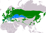
Íomhá:PeriparusAterIUCN2018 2.png

Page contents not supported in other languages.
Ón Vicipéid, an chiclipéid shaor.

Taispeáin leagan ardtaifigh den íomhá(3,507 × 2,480 picteilín, méid comhaid: 978 KB, cineál MIME: image/png)

Seo comhad as An Cómhaoin Viciméid. Tá an tuairisc as an leathanach tuairisc Cómhaoin a leanas thíos.
Is stór comhaid meáin Saor é an Cómhaoin Viciméid. Is féidir leat cabhrú.
File:PeriparusAterIUCN.svg is a vector version of this file. It should be used in place of this PNG file when not inferior.

File:PeriparusAterIUCN2018 2.png → File:PeriparusAterIUCN.svg

For more information, see Help:SVG.

In other languages
Alemannisch  Bahasa Indonesia  Bahasa Melayu  British English  català  čeština  dansk  Deutsch  eesti  English  español  Esperanto  euskara  français  Frysk  galego  hrvatski  Ido  italiano  lietuvių  magyar  Nederlands  norsk bokmål  norsk nynorsk  occitan  Plattdüütsch  polski  português  português do Brasil  română  Scots  sicilianu  slovenčina  slovenščina  suomi  svenska  Tiếng Việt  Türkçe  vèneto  Ελληνικά  беларуская (тарашкевіца)  български  македонски  нохчийн  русский  српски / srpski  татарча/tatarça  українська  ქართული  հայերեն  বাংলা  தமிழ்  മലയാളം  ไทย  한국어  日本語  简体中文  繁體中文  עברית  العربية  فارسی  +/−
New SVG image

Achoimriú

Tuairisc
Slovenčina: mapa rozšírenia sýkorky uhliarky Periparus ater podľa IUCN verzia 2018.2 ,
legenda: Hniezdiaci, celoročný výskyt (#008000), Nehniezdiaci (#007FFF)
English: map of coal tit Periparus ater according to IUCN 2018.2 ,
Legend: Extant, resident (#008000),Extant, non-breeding (#007FFF)
Dáta
Foinse Made with Natural Earth. Free vector and raster map data @ naturalearthdata.com. Range map from BirdLife International 2017. Periparus ater (amended version of 2016 assessment). The IUCN Red List of Threatened Species 2017: e.T22735965A118835425. https://dx.doi.org/10.2305/IUCN.UK.2017-3.RLTS.T22735965A118835425.en. Downloaded on 18 February 2019 as visual indicator of distribution.
Údar SanoAK: Alexander Kürthy

Ceadúnú

The use of spatial data from the IUCN Red List web site to produce species distribution maps is subject to the Attribution-Share Alike Creative Commons License. In short: you are free to distribute and modify the file as long as you attribute its authors and the IUCN Red List.

العربيَّة | English | español | français | македонски | മലയാളം | português | +/−

w:ga:Creative Commons
sannadh comhroinn araon
This file is licensed under the Creative Commons Attribution-Share Alike 3.0 Unported license.
Creidiúint: IUCN Red List of Threatened Species, species assessors and the authors of the spatial data.
Is féidir:
  • an saothar seo a roinnt – an saothar seo a chóipeáil, a dháil amach, agus a tharchur
  • an saothar seo a athmheascadh – an saothar seo a oiriúnú
Ach amháin má leantar na coinníollacha seo a leanas:
  • sannadh – Ní mor creidiúint a thabhairt leis an saothar, faoi mar a shonraigh an údar nó tabharthóir an ceadúnais (ach ná húsáid modh a thugann le fios go thacaíonn sé/sí tú féin nó an úsáid a bhaineann tú as an saothar).
  • comhroinn araon – Má athraíonn tú nó síneann tú amach an saothar seo, ní féidir é a dháileadh ach amhaín faoin gceadúnas céanna nó ceann cosúil leis an gceann seo.
VRT Wikimedia

This work is free and may be used by anyone for any purpose. If you wish to use this content, you do not need to request permission as long as you follow any licensing requirements mentioned on this page.

The Wikimedia Foundation has received an e-mail confirming that the copyright holder has approved publication under the terms mentioned on this page. This correspondence has been reviewed by a Volunteer Response Team (VRT) member and stored in our permission archive. The correspondence is available to trusted volunteers as ticket #2010061810022172.

If you have questions about the archived correspondence, please use the VRT noticeboard. Ticket link: https://ticket.wikimedia.org/otrs/index.pl?Action=AgentTicketZoom&TicketNumber=2010061810022172
Find other files from the same ticket: SDC query (SPARQL)

Captions

Add a one-line explanation of what this file represents
map of coal tit (Periparus ater) according to IUCN 2018.2

Items portrayed in this file

taispeánann sé/sí

18 Feabhra 2019

MIME type Béarla

image/png

checksum Béarla

81bb4d27d3b12ef07a32909287d870284894ceb1

determination method Béarla: SHA-1 Béarla

data size Béarla

1,000,999 Beart

2,480 picteilín

3,507 picteilín

Stair chomhaid

Cliceáil ar dáta/am chun an comhad a radharc mar a bhí sé ag an am sin.

Dáta/AmMionsamhailToisíÚsáideoirNóta tráchta
faoi láthair08:43, 18 Feabhra 2019Mionsamhail do leagan ó 08:43, 18 Feabhra 20193,507 × 2,480 (978 KB)SanoAKUser created page with UploadWizard

Tá nasc chuig an gcomhad seo ar 2 an leathanach seo a leanas:

Global file usage

The following other wikis use this file:

Meiteasonraí