
Íomhá:Oosterland Wieringen.jpg

Size of this preview: 800 × 533 picteilín. Other resolutions: 320 × 213 picteilín | 640 × 427 picteilín | 1,024 × 683 picteilín | 1,200 × 800 picteilín.
Taispeáin leagan ardtaifigh den íomhá (1,200 × 800 picteilín, méid comhaid: 703 KB, cineál MIME: image/jpeg)
| Seo comhad as An Cómhaoin Viciméid. Tá an tuairisc as an leathanach tuairisc Cómhaoin a leanas thíos.
|
Achoimriú
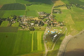
| Tuairisc | Oosterland in North-Holland, Netherlands |
| Dáta | |
| Foinse | Obair féin |
| Údar | Jan Arkesteijn |
| Camera location | | View this and other nearby images on: OpenStreetMap |
|---|
Ceadúnú
| This work has been released into the public domain by its author, I, Jan Arkesteijn. This applies worldwide. In some countries this may not be legally possible; if so: I, Jan Arkesteijn grants anyone the right to use this work for any purpose, without any conditions, unless such conditions are required by law. |
Stair chomhaid
Cliceáil ar dáta/am chun an comhad a radharc mar a bhí sé ag an am sin.
| Dáta/Am | Mionsamhail | Toisí | Úsáideoir | Nóta tráchta | |
|---|---|---|---|---|---|
| faoi láthair | 13:54, 23 Iúil 2007 | | 1,200 × 800 (703 KB) | Jan Arkesteijn | {{Information |Description=Oosterland in North-Holland, Netherlands |Source=self-made |Date=21-7-2007 |Author= Jan Arkesteijn }} Category:Wieringen |
Úsáid comhaid
Tá nasc chuig an gcomhad seo ar na leathanaigh seo a leanas:
Global file usage
The following other wikis use this file:
- Úsáid ar ar.wikipedia.org
- Úsáid ar arz.wikipedia.org
- Úsáid ar ca.wikipedia.org
- Úsáid ar de.wikipedia.org
- Úsáid ar en.wikipedia.org
- Úsáid ar eo.wikipedia.org
- Úsáid ar eu.wikipedia.org
- Úsáid ar fa.wikipedia.org
- Úsáid ar fi.wikipedia.org
- Úsáid ar fr.wikipedia.org
- Úsáid ar fy.wikipedia.org
- Úsáid ar it.wikipedia.org
- Úsáid ar nl.wikipedia.org
- Úsáid ar pt.wikipedia.org
- Úsáid ar ro.wikipedia.org
- Úsáid ar ru.wikipedia.org
- Úsáid ar simple.wikipedia.org
- Úsáid ar sv.wikipedia.org
- Úsáid ar uk.wikipedia.org
- Úsáid ar vi.wikipedia.org
- Úsáid ar www.wikidata.org
- Úsáid ar zh-min-nan.wikipedia.org
- Úsáid ar zh.wikipedia.org