
Íomhá:New York state geographic map-en.svg

Size of this PNG preview of this SVG file: 800 × 569 picteilín. Other resolutions: 320 × 228 picteilín | 640 × 455 picteilín | 1,024 × 729 picteilín | 1,280 × 911 picteilín | 2,560 × 1,821 picteilín | 2,811 × 2,000 picteilín.
Taispeáin leagan ardtaifigh den íomhá (Comhad SVG, ainmniúil 2,811 × 2,000 picteilíni, méid comhaid: 18.34 MB)
| Seo comhad as An Cómhaoin Viciméid. Tá an tuairisc as an leathanach tuairisc Cómhaoin a leanas thíos.
|
Achoimriú
| Cur síos |
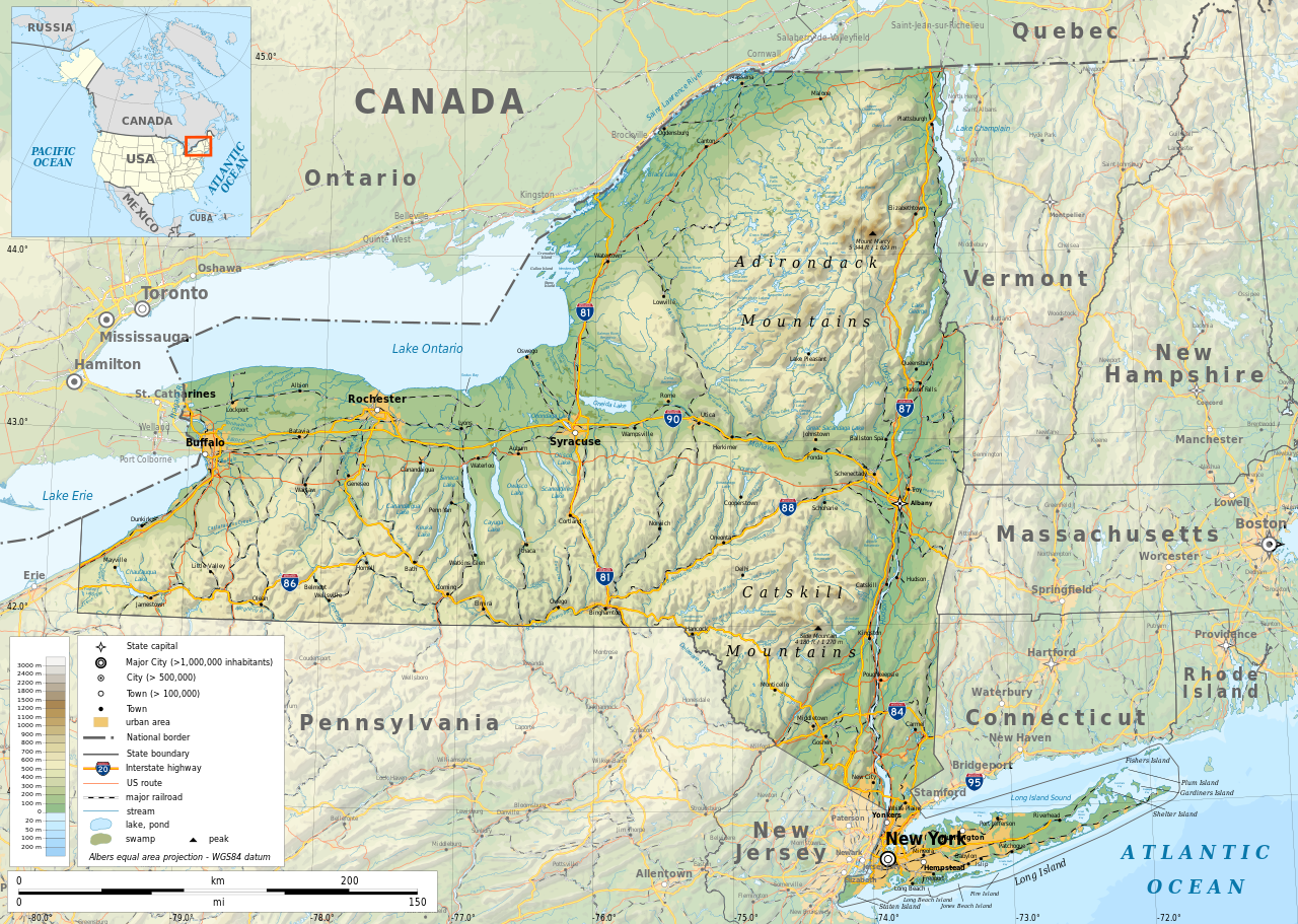
English: Geographic map of New York state in English. Geographic limits of the map:
|
| Dáta | |
| Foinse |
Obair féin
|
| Cruthaitheoir | |
| Ceadúnas (Athúsáid a bhaint as an gcomhad seo) |
Any use of this map is subject of the license(s) stated below with the condition that you credit (Wikimedia Commons user: Ikonact) as the author . A message with a reply address would also be greatly appreciated. |
| Georeferencing | If inappropriate please set warp_status = skip to hide. |
|

|
This SVG file contains embedded text that can be translated into your language, using any capable SVG editor, text editor or the SVG Translate tool. For more information see: About translating SVG files. |
Ceadúnú
| This work contains information from OpenStreetMap, which is made available under the Open Database License (ODbL).
The ODbL does not require any particular license for maps produced from ODbL data. Prior to 1 August 2020, map tiles produced by the OpenStreetMap Foundation were licensed under the CC-BY-SA-2.0 license. Maps produced by other people may be subject to other licences. |
Is mise sealbhóir cóipchirt an shaothair seo agus foilsím é faoin gceadúnas seo a leanas:
This file is licensed under the Creative Commons Attribution-Share Alike 4.0 International license.
- Is féidir:
- an saothar seo a roinnt – an saothar seo a chóipeáil, a dháil amach, agus a tharchur
- an saothar seo a athmheascadh – an saothar seo a oiriúnú
- Ach amháin má leantar na coinníollacha seo a leanas:
- sannadh – Ní mor creidiúint a thabhairt leis an saothar, faoi mar a shonraigh an údar nó tabharthóir an ceadúnais (ach ná húsáid modh a thugann le fios go thacaíonn sé/sí tú féin nó an úsáid a bhaineann tú as an saothar).
- comhroinn araon – Má athraíonn tú nó síneann tú amach an saothar seo, ní féidir é a dháileadh ach amhaín faoin gceadúnas céanna nó ceann cosúil leis an gceann seo.
Stair chomhaid
Cliceáil ar dáta/am chun an comhad a radharc mar a bhí sé ag an am sin.
| Dáta/Am | Mionsamhail | Toisí | Úsáideoir | Nóta tráchta | |
|---|---|---|---|---|---|
| faoi láthair | 12:15, 2 Samhain 2023 | | 2,811 × 2,000 (18.34 MB) | Ikonact | corrected some typos in names // Editing SVG source code using c:User:Rillke/SVGedit.js |
| 10:22, 14 Deireadh Fómhair 2019 |  | 2,811 × 2,000 (18.41 MB) | Ikonact | better dealing with fall back font | |
| 21:19, 12 Deireadh Fómhair 2019 |  | 2,811 × 2,000 (20.53 MB) | Ikonact | + fall back font, more towns and islands, provinces | |
| 23:33, 11 Deireadh Fómhair 2019 |  | 2,811 × 2,000 (20.47 MB) | Ikonact | error corrected | |
| 23:23, 11 Deireadh Fómhair 2019 |  | 2,811 × 2,000 (20.47 MB) | Ikonact | river and lake names added | |
| 21:58, 8 Deireadh Fómhair 2019 |  | 2,811 × 2,000 (20.33 MB) | Ikonact | some improvements, roads and cities in Canada | |
| 07:40, 22 Meán Fómhair 2019 |  | 2,811 × 2,000 (14.39 MB) | Ikonact | small corrections | |
| 20:49, 21 Meán Fómhair 2019 |  | 2,811 × 2,000 (14.39 MB) | Ikonact | + road names | |
| 20:23, 21 Meán Fómhair 2019 |  | 2,811 × 2,000 (14.31 MB) | Ikonact | +names | |
| 22:01, 20 Meán Fómhair 2019 |  | 2,811 × 2,000 (15.37 MB) | Ikonact | == {{int:filedesc}} == {{Information |description={{en|1=Geographic map of New York state in English. Geographic limits of the map:}} *N: 45.30° N *S: 40.30° N *W: 80.20° W *E: 71.00° W Albers equal area projection; WGS 84 datum |date=2019-09-21 |source={{own}} *Sources of data:<br/> **Topography: ETOPO1 (public domain);<br/> **Public domain data provided by the National Atlas of the United States of America;<br/> *Tool:<br/> **The map is created with Octave scripts d... |
Úsáid comhaid
Tá nasc chuig an gcomhad seo ar na leathanaigh seo a leanas:
Global file usage
The following other wikis use this file:
- Úsáid ar af.wikipedia.org
- Úsáid ar ang.wikipedia.org
- Úsáid ar az.wikipedia.org
- Úsáid ar be.wikipedia.org
- Úsáid ar bg.wikipedia.org
- Úsáid ar bn.wikipedia.org
- Úsáid ar ca.wikipedia.org
- Úsáid ar en.wikipedia.org
- Úsáid ar eo.wikipedia.org
- Úsáid ar fr.wikipedia.org
- Úsáid ar gl.wikipedia.org
- Úsáid ar ha.wikipedia.org
- Úsáid ar hu.wikipedia.org
- Úsáid ar hy.wikipedia.org
- Úsáid ar id.wikipedia.org
- Úsáid ar lt.wikipedia.org
- Úsáid ar mhr.wikipedia.org
- Úsáid ar ml.wikipedia.org
- Úsáid ar os.wikipedia.org
- Úsáid ar pcd.wikipedia.org
- Úsáid ar pl.wikipedia.org
- Úsáid ar sh.wikipedia.org
- Úsáid ar tg.wikipedia.org
- Úsáid ar tr.wikipedia.org
- Úsáid ar tt.wikipedia.org
- Úsáid ar uk.wikipedia.org
- Úsáid ar www.wikidata.org