
Íomhá:Milecastle 39 on Hadrian's Wall.jpg

Size of this preview: 800 × 533 picteilín. Other resolutions: 320 × 213 picteilín | 640 × 427 picteilín | 1,024 × 683 picteilín | 1,280 × 853 picteilín | 2,304 × 1,536 picteilín.
Taispeáin leagan ardtaifigh den íomhá (2,304 × 1,536 picteilín, méid comhaid: 920 KB, cineál MIME: image/jpeg)
| Seo comhad as An Cómhaoin Viciméid. Tá an tuairisc as an leathanach tuairisc Cómhaoin a leanas thíos.
|
Achoimriú
| Tuairisc |
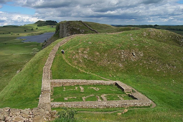
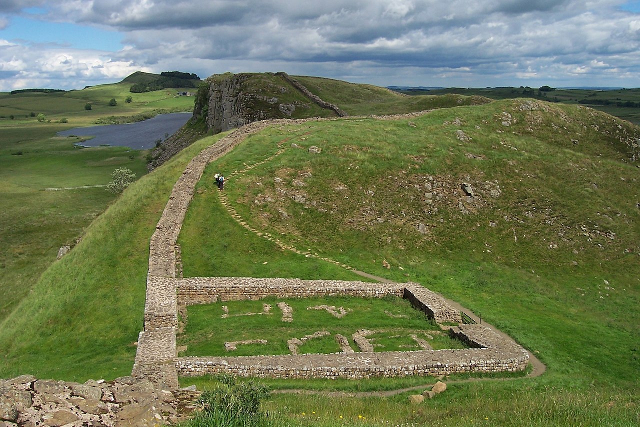
English: The remains of Milecastle 39 (coordinates 55° 0' 13.12" N, 2° 22' 32.74" W) on Hadrian's Wall; near Steel Rigg, looking east from a ridge along the Hadrian's Wall Path. Milecastle 39 is also known as Castle Nick.
Svenska: Ruinerna efter Milecastle 39 (koordinater 55° 0' 13.12" N, 2° 22' 32.74" V), beläget nära Steel Rigg utmed Hadrianus mur. Fortifikationen – som också kallas Castle Nick – vetter mot öster och är byggd på en ås längs vandringsleden Hadrian's Wall Path. |
||
| Dáta | |||
| Foinse | Photograph by uploader | ||
| Údar | Adam Cuerden | ||
| Ceadúnas (Athúsáid a bhaint as an gcomhad seo) |
|
Stair chomhaid
Cliceáil ar dáta/am chun an comhad a radharc mar a bhí sé ag an am sin.
| Dáta/Am | Mionsamhail | Toisí | Úsáideoir | Nóta tráchta | |
|---|---|---|---|---|---|
| faoi láthair | 14:16, 30 Meitheamh 2007 | | 2,304 × 1,536 (920 KB) | Adam Cuerden | Milecastle 39 on Hadrian's Wall, near Steel Rigg. |
Úsáid comhaid
Níl nasc ó aon leathanach eile don íomhá seo.
Global file usage
The following other wikis use this file:
- Úsáid ar ar.wikipedia.org
- Úsáid ar arz.wikipedia.org
- Úsáid ar be.wikipedia.org
- Úsáid ar ca.wikipedia.org
- Úsáid ar cs.wikipedia.org
- Úsáid ar de.wikipedia.org
- Úsáid ar de.wikivoyage.org
- Úsáid ar en.wikipedia.org
- Hadrian
- Roman Empire
- Milecastle
- Wikipedia:Featured picture candidates/Milecastle 39 on Hadrian's Wall
- Wikipedia:Featured picture candidates/July-2007
- Portal:Scotland/Selected article/2008
- Milecastle 39
- Portal:Scotland/Selected article/Week 11, 2008
- Hadrian's Wall
- Crag Lough
- Themes in A Song of Ice and Fire
- Portal:Ancient Rome
- Limes Britannicus
- Wikipedia:WikiProject Military history/News/July 2020/Book reviews
- Úsáid ar en.wikivoyage.org
- Úsáid ar es.wikipedia.org
- Úsáid ar fa.wikipedia.org
- Úsáid ar fi.wikipedia.org
- Úsáid ar fr.wikipedia.org
- Úsáid ar fr.wikivoyage.org
- Úsáid ar he.wikipedia.org
- Úsáid ar hr.wikipedia.org
- Úsáid ar hu.wikipedia.org
- Úsáid ar hy.wikipedia.org
- Úsáid ar it.wikipedia.org
- Úsáid ar ja.wikipedia.org
- Úsáid ar nl.wikipedia.org
View more global usage of this file.