
Íomhá:Maui wildfires 2023.jpg

Taispeáin leagan ardtaifigh den íomhá (2,766 × 2,017 picteilín, méid comhaid: 3.45 MB, cineál MIME: image/jpeg)
| Seo comhad as An Cómhaoin Viciméid. Tá an tuairisc as an leathanach tuairisc Cómhaoin a leanas thíos.
|
Achoimriú
| Tuairisc |
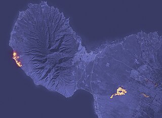
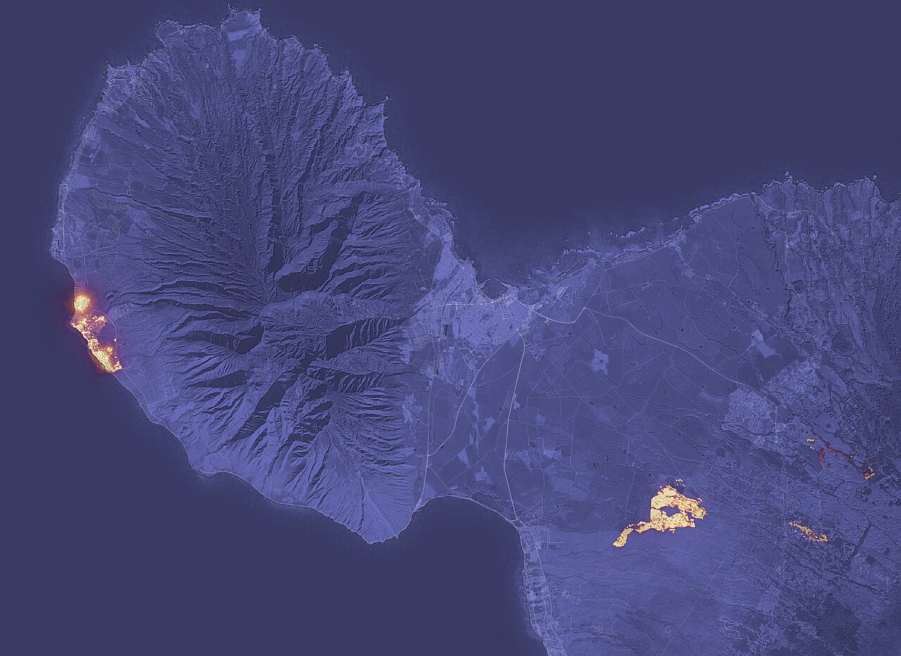
English: A fast-moving wildfire has devastated the historic town of Lahaina on Maui, Hawaii’s second-largest island.
The image above shows the signature of the fire at 10:25 p.m. local time on August 8, 2023, as observed by the Operational Land Imager (OLI) on the Landsat 8 satellite. Much of Lahaina, a town with a resident population of nearly 13,000 people, appeared to be on fire at the time of the image. Another large fire burned northeast of Kihei. The image was composed from OLI observations of shortwave infrared light (band 6). Infrared observations are useful for distinguishing the locations of active fires, shown here in yellow. The shortwave infrared data were overlaid on a natural-color mosaic image based on Landsat 8 observations for added geographic detail. The fires occurred during a period of strong winds and dry conditions in Maui. Between August 7-9, 2023, the island experienced peak gusts that ranged from 45 to 67 miles (72 to 107 kilometers) per hour, according to the National Weather Service. The presence of a strong high-pressure area to north of the island and Hurricane Dora to the south may have helped fuel the winds. An analysis by the U.S. Drought Monitor shows that the southwestern part of the island was in the midst of moderate to severe drought at the time of the fires. Maui County has reported damage to hundreds of structures, with widespread damage in the Lahaina harbor area. On August 9, authorities were continuing to conduct search and rescue operations. NASA’s Earth Applied Sciences Disasters program area has been activated in support of the fires in Hawaii. As new information becomes available, the team will be posting maps and data products on its open-access mapping portal. |
| Dáta | |
| Foinse | https://earthobservatory.nasa.gov/images/151688/devastation-in-maui |
| Údar | NASA - NASA Earth Observatory |
Ceadúnú
| Chruthaigh NASA an comhad seo, agus tógadh as suíomh Greasáin NASA nó foilseachán NASA é. Tá gach saothar den saghas sin sa fearann poiblí ach amháin an suaitheantas NASA, mar ní féidir saothair de chuid rialtas cónaidhme Stáit Aontaithe Mheiriceá a chur faoi chóipcheart. Féach ar an leathanach pholasaí cóipchirt NASA nó an leathanach pholasaí íomhanna JPL le tuilleadh eolais. | ||
 |
Rabhaidh:
|
Stair chomhaid
Cliceáil ar dáta/am chun an comhad a radharc mar a bhí sé ag an am sin.
| Dáta/Am | Mionsamhail | Toisí | Úsáideoir | Nóta tráchta | |
|---|---|---|---|---|---|
| faoi láthair | 06:40, 11 Lúnasa 2023 | | 2,766 × 2,017 (3.45 MB) | JoleBruh | Uploaded a work by NASA - NASA Earth Observatory from https://earthobservatory.nasa.gov/images/151688/devastation-in-maui with UploadWizard |
Úsáid comhaid
Tá nasc chuig an gcomhad seo ar na leathanaigh seo a leanas:
Global file usage
The following other wikis use this file:
- Úsáid ar ar.wikipedia.org
- Úsáid ar be.wikipedia.org
- Úsáid ar en.wikipedia.org
- Úsáid ar es.wikipedia.org
- Úsáid ar he.wikipedia.org
- Úsáid ar incubator.wikimedia.org
- Úsáid ar ms.wikipedia.org
- Úsáid ar nl.wikipedia.org
- Úsáid ar ru.wikipedia.org
- Úsáid ar th.wikipedia.org
- Úsáid ar tr.wikipedia.org
- Úsáid ar ur.wikipedia.org
- Úsáid ar uz.wikipedia.org
- Úsáid ar www.wikidata.org