
Íomhá:Mars Géolocalisation.jpg
Size of this preview: 800 × 400 picteilín. Other resolutions: 320 × 160 picteilín | 640 × 320 picteilín | 1,024 × 512 picteilín | 1,280 × 640 picteilín | 2,048 × 1,024 picteilín.
Taispeáin leagan ardtaifigh den íomhá (2,048 × 1,024 picteilín, méid comhaid: 1.55 MB, cineál MIME: image/jpeg)
| Seo comhad as An Cómhaoin Viciméid. Tá an tuairisc as an leathanach tuairisc Cómhaoin a leanas thíos.
|
Achoimriú
| Tuairisc |
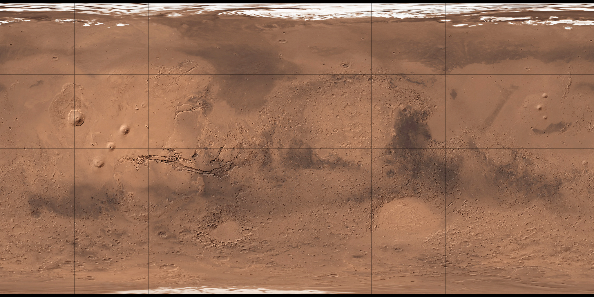
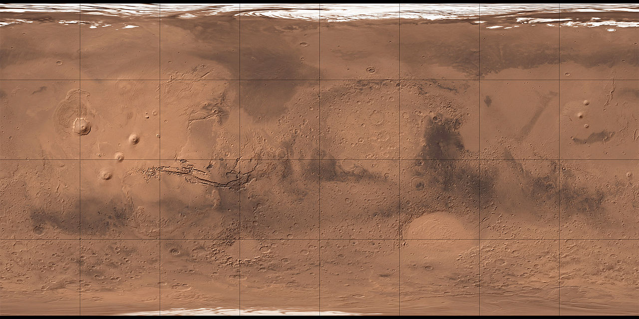
Français : Carte de Mars reconstituée à partir des mesures de Mars Global Surveyor (MOLA) et des observations de Viking. |
| Dáta | 2 Lúnasa 2008 (upload date) |
| Foinse | MOLA Shaded Relief & Viking. |
| Údar | NASA, USGS et Who killed Bambi ? pour les retouches. |
| Leaganacha eile |

Ceadúnú
| Chruthaigh NASA an comhad seo, agus tógadh as suíomh Greasáin NASA nó foilseachán NASA é. Tá gach saothar den saghas sin sa fearann poiblí ach amháin an suaitheantas NASA, mar ní féidir saothair de chuid rialtas cónaidhme Stáit Aontaithe Mheiriceá a chur faoi chóipcheart. Féach ar an leathanach pholasaí cóipchirt NASA nó an leathanach pholasaí íomhanna JPL le tuilleadh eolais. | ||
 |
Rabhaidh:
|
This image is in the public domain in the United States because it only contains materials that originally came from the United States Geological Survey, an agency of the United States Department of the Interior. For more information, see the official USGS copyright policy.
|
| Annotations | This image is annotated: View the annotations at Commons |
Stair chomhaid
Cliceáil ar dáta/am chun an comhad a radharc mar a bhí sé ag an am sin.
| Dáta/Am | Mionsamhail | Toisí | Úsáideoir | Nóta tráchta | |
|---|---|---|---|---|---|
| faoi láthair | 11:34, 2 Lúnasa 2008 | | 2,048 × 1,024 (1.55 MB) | Who killed Bambi ? | {{Information |Description= |Source= |Date= |Author= |Permission= |other_versions= }} |
| 13:07, 27 Iúil 2008 |  | 2,048 × 1,024 (1.96 MB) | Who killed Bambi ? | {{Information |Description={{fr|1=Carte de Mars reconstituée à partir des observations de Viking}} |Source=ftp://ftpflag.wr.usgs.gov/dist/pigpen/mars/usgs/mdim1_color/ |Author=USGS |Date=03/04/2004 |Permission= |other_versions= }} {{ImageUpload|full}} |
Úsáid comhaid
Níl nasc ó aon leathanach eile don íomhá seo.
Global file usage
The following other wikis use this file:
- Úsáid ar ar.wikipedia.org
- أرض عشتار
- ندبة هيبيس
- وادي النيل (المريخ)
- فاستيتاس بورياليس
- أريس فاليس
- جبل أوليمبوس مونز
- قمة اسكريوس
- جبل ماكسويل
- فوهة غيل
- فكتوريا (فوهة)
- جبل الريح (المريخ)
- جبل غولا
- جبل أبيونا
- جبل أنالا
- جبل ساباس
- جبل ثيا
- جبل ماعت
- جبل أوشاس
- وجه على المريخ
- أرض العرب (المريخ)
- قالب:خريطة مواقع المريخ
- منطقة ألفا
- منطقة بيتا
- بافونيس مونس
- وادي مارينر
- هضبة سوريا (المريخ)
- الحوض القطبي الشمالي
- هيكاتيس ثولوس (المريخ)
- يوتوبيا بلانيشيا
- Úsáid ar az.wikipedia.org
- Úsáid ar ba.wikipedia.org
- Úsáid ar be.wikipedia.org
- Úsáid ar bg.wikipedia.org
- Úsáid ar ca.wikipedia.org
View more global usage of this file.