
Íomhá:Map of Rhode Island NA.png
Size of this preview: 776 × 600 picteilín. Other resolutions: 311 × 240 picteilín | 621 × 480 picteilín | 994 × 768 picteilín | 1,280 × 989 picteilín | 2,122 × 1,640 picteilín.
Taispeáin leagan ardtaifigh den íomhá (2,122 × 1,640 picteilín, méid comhaid: 822 KB, cineál MIME: image/png)
| Seo comhad as An Cómhaoin Viciméid. Tá an tuairisc as an leathanach tuairisc Cómhaoin a leanas thíos.
|
Achoimriú
| Tuairisc |
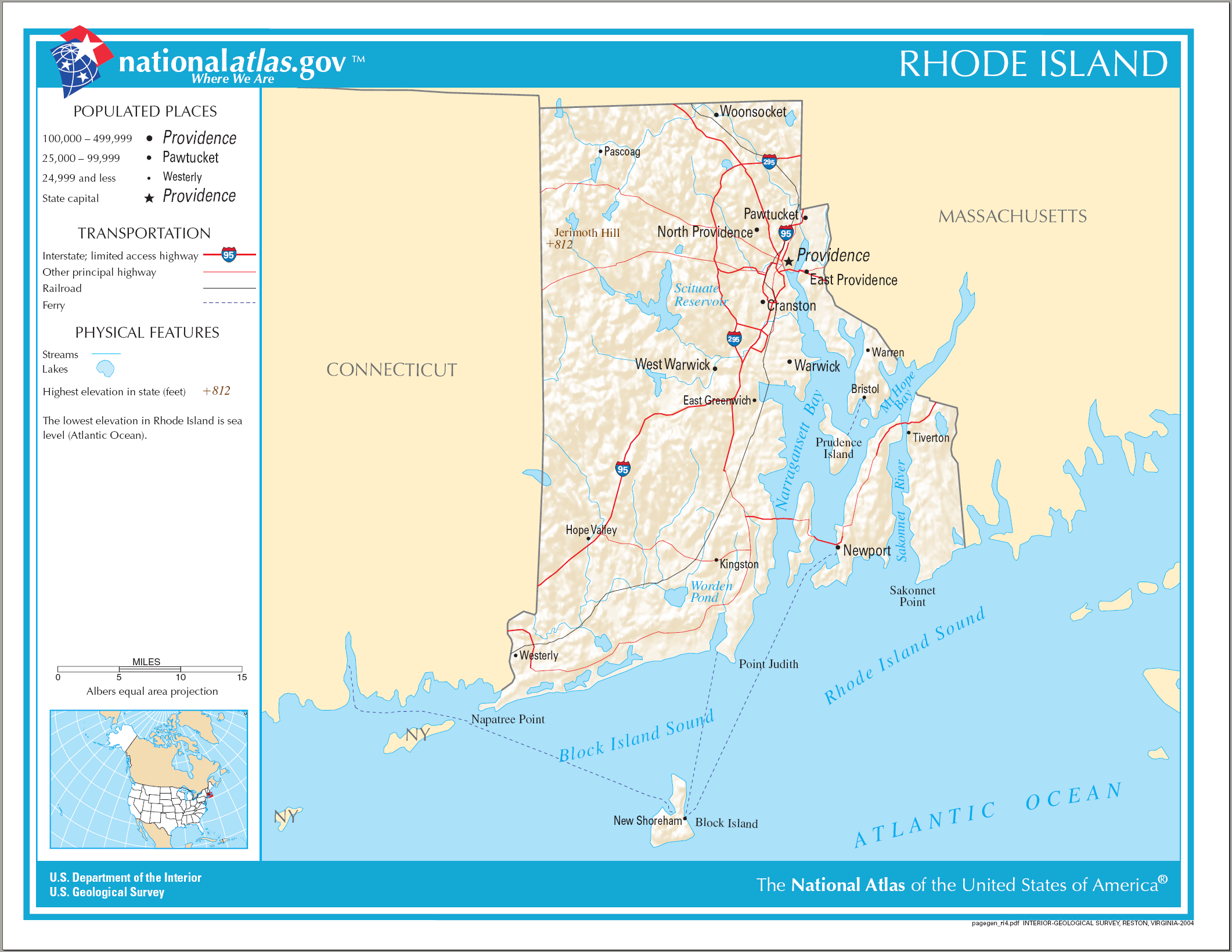
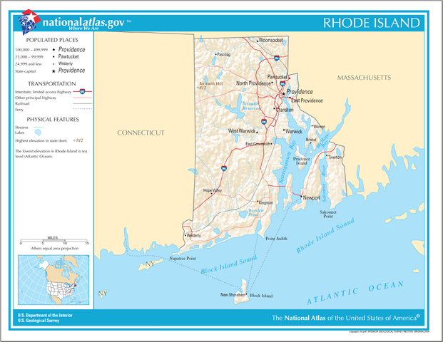
English: National Atlas map of Rhode Island. |
| Dáta | |
| Foinse | National Atlas |
| Údar |
Ceadúnú
This map was obtained from an edition of the National Atlas of the United States. Like almost all works of the U.S. federal government, works from the National Atlas are in the public domain in the United States.
Online access: NationalAtlas.gov | 1970 print edition: Library of Congress, Perry-Castañeda Library
|
Stair chomhaid
Cliceáil ar dáta/am chun an comhad a radharc mar a bhí sé ag an am sin.
| Dáta/Am | Mionsamhail | Toisí | Úsáideoir | Nóta tráchta | |
|---|---|---|---|---|---|
| faoi láthair | 14:16, 17 Aibreán 2015 | | 2,122 × 1,640 (822 KB) | RokerHRO | optipng -o7 -i0 → 18.34% decrease |
| 08:22, 15 Lúnasa 2006 |  | 2,122 × 1,640 (1,007 KB) | Huebi~commonswiki | {{Information| |Description=Map of Rhode Island |Source=[http://www.nationalatlas.gov National Atlas] }} Category:Maps of the United States Category:Maps of Rhode Island {{PD-USGov-Atlas}} |
Úsáid comhaid
Tá nasc chuig an gcomhad seo ar na leathanaigh seo a leanas:
Global file usage
The following other wikis use this file:
- Úsáid ar ang.wikipedia.org
- Úsáid ar be.wikipedia.org
- Úsáid ar ca.wikipedia.org
- Úsáid ar de.wikipedia.org
- Úsáid ar en.wikipedia.org
- Úsáid ar fi.wikipedia.org
- Úsáid ar gl.wikipedia.org
- Úsáid ar hu.wikipedia.org
- Úsáid ar hy.wikipedia.org
- Úsáid ar ja.wikipedia.org
- Úsáid ar ko.wikipedia.org
- Úsáid ar lt.wikipedia.org
- Úsáid ar mhr.wikipedia.org
- Úsáid ar mr.wikipedia.org
- Úsáid ar os.wikipedia.org
- Úsáid ar sw.wikipedia.org
- Úsáid ar tg.wikipedia.org
- Úsáid ar tt.wikipedia.org
- Úsáid ar www.wikidata.org
- Úsáid ar zea.wikipedia.org