
Íomhá:Map of Darfur-en.png
Size of this preview: 507 × 600 picteilín. Other resolutions: 203 × 240 picteilín | 406 × 480 picteilín | 649 × 768 picteilín | 865 × 1,024 picteilín | 1,731 × 2,048 picteilín | 2,583 × 3,056 picteilín.
Taispeáin leagan ardtaifigh den íomhá (2,583 × 3,056 picteilín, méid comhaid: 1.09 MB, cineál MIME: image/png)
| Seo comhad as An Cómhaoin Viciméid. Tá an tuairisc as an leathanach tuairisc Cómhaoin a leanas thíos.
|
Achoimriú
| Tuairisc |
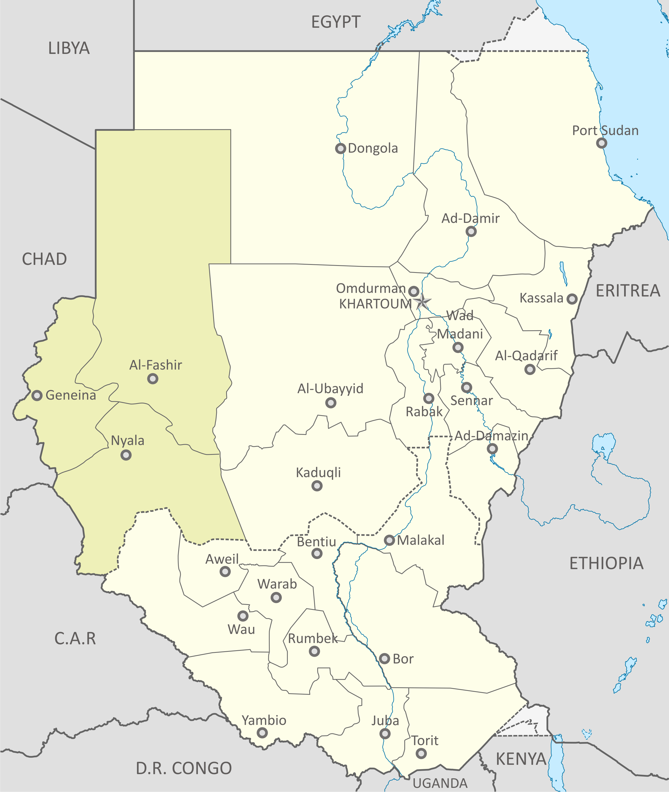
English: Map of Region of Darfur, Sudan |
| Dáta | |
| Foinse | Sudan location map.svg |
| Údar |
|
Ceadúnú
Is mise sealbhóir cóipchirt an shaothair seo agus foilsím é faoi na ceadúnais seo a leanas:
This file is licensed under the Creative Commons Attribution-Share Alike 3.0 Unported license.
- Is féidir:
- an saothar seo a roinnt – an saothar seo a chóipeáil, a dháil amach, agus a tharchur
- an saothar seo a athmheascadh – an saothar seo a oiriúnú
- Ach amháin má leantar na coinníollacha seo a leanas:
- sannadh – Ní mor creidiúint a thabhairt leis an saothar, faoi mar a shonraigh an údar nó tabharthóir an ceadúnais (ach ná húsáid modh a thugann le fios go thacaíonn sé/sí tú féin nó an úsáid a bhaineann tú as an saothar).
- comhroinn araon – Má athraíonn tú nó síneann tú amach an saothar seo, ní féidir é a dháileadh ach amhaín faoin gceadúnas céanna nó ceann cosúil leis an gceann seo.

|
Tugtar cead an doiciméad seo a chóipeáil, a dháileadh agus/nó a mhodhnú faoi théarmaí an Ceadúnas Doiciméadúcháin Saor ó GNU, Leagan 1.2 nó aon leagan níos déanaí a d’fhoilsigh an Fondúireacht Bogearraí Saor in Aisce; gan aon Rannóga Inmheánacha, gan aon Téacsanna Clúdaigh Tosaigh, agus gan aon Téacsanna Clúdaigh Cúil. Tá cóip den cheadúnas san áireamh sa chuid dar teideal Ceadúnas Doiciméadúcháin Saor ó GNU. |
Is féidir leat a roghnú an ceadúnas do rogha
Stair chomhaid
Cliceáil ar dáta/am chun an comhad a radharc mar a bhí sé ag an am sin.
| Dáta/Am | Mionsamhail | Toisí | Úsáideoir | Nóta tráchta | |
|---|---|---|---|---|---|
| faoi láthair | 19:24, 12 Eanáir 2011 | | 2,583 × 3,056 (1.09 MB) | Пакко | {{Information |Description={{en|1=Map of Region of Darfur, Sudan}} |Source={{own}} |Author=Пакко |Date=2011-01-12 |Permission= |other_versions= }} Category:Maps of Darfur |
Úsáid comhaid
Tá nasc chuig an gcomhad seo ar na leathanaigh seo a leanas:
Global file usage
The following other wikis use this file:
- Úsáid ar ca.wikipedia.org
- Úsáid ar ckb.wikipedia.org
- Úsáid ar en.wikipedia.org
- Úsáid ar fa.wikipedia.org
- Úsáid ar id.wikipedia.org
- Úsáid ar lt.wikipedia.org
- Úsáid ar mzn.wikipedia.org
- Úsáid ar pnb.wikipedia.org
- Úsáid ar www.wikidata.org