
Íomhá:Map of Alaska highlighting Nome Census Area.svg

Size of this PNG preview of this SVG file: 800 × 423 picteilín. Other resolutions: 320 × 169 picteilín | 640 × 338 picteilín | 1,024 × 541 picteilín | 1,280 × 677 picteilín | 2,560 × 1,353 picteilín | 1,470 × 777 picteilín.
Taispeáin leagan ardtaifigh den íomhá (Comhad SVG, ainmniúil 1,470 × 777 picteilíni, méid comhaid: 338 KB)
| Seo comhad as An Cómhaoin Viciméid. Tá an tuairisc as an leathanach tuairisc Cómhaoin a leanas thíos.
|
Achoimriú
| Tuairisc |
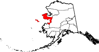
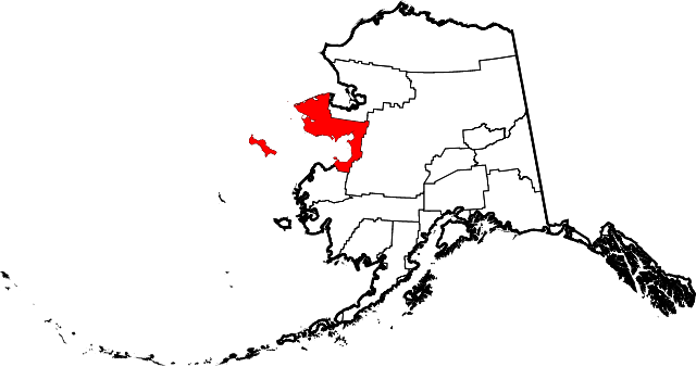
English: This is a locator map showing Nome Census Area in Alaska |
| Dáta | |
| Foinse |
Obair féin: English: The maps use data from nationalatlas.gov, specifically countyp020.tar.gz on the Raw Data Download page. The maps also use state outline data from statesp020.tar.gz. The Florida maps use hydrogm020.tar.gz to display Lake Okeechobee. |
| Údar | David Benbennick |
Ceadúnú
| I, the copyright holder of this work, release this work into the public domain. This applies worldwide. In some countries this may not be legally possible; if so: I grant anyone the right to use this work for any purpose, without any conditions, unless such conditions are required by law. |
Stair chomhaid
Cliceáil ar dáta/am chun an comhad a radharc mar a bhí sé ag an am sin.
| Dáta/Am | Mionsamhail | Toisí | Úsáideoir | Nóta tráchta | |
|---|---|---|---|---|---|
| faoi láthair | 19:28, 5 Márta 2006 | | 1,470 × 777 (338 KB) | David Benbennick | {{subst:User:Dbenbenn/clm|county=Nome Census Area|state=Alaska|type=borough and census area}} |
Úsáid comhaid
Tá nasc chuig an gcomhad seo ar na leathanaigh seo a leanas:
Global file usage
The following other wikis use this file:
- Úsáid ar az.wikipedia.org
- Úsáid ar bpy.wikipedia.org
- Úsáid ar ca.wikipedia.org
- Brevig Mission
- Diomede
- Elim (Alaska)
- Gambell
- Golovin
- Koyuk
- Nome (Alaska)
- Port Clarence
- Savoonga
- Shaktoolik
- Shishmaref
- St. Michael (Alaska)
- Stebbins
- Teller (Alaska)
- Unalakleet
- Wales (Alaska)
- White Mountain
- Llista de boroughs i àrees censals d'Alaska
- Plantilla:Àrea censal de Nome
- Categoria:Àrea censal de Nome
- Úsáid ar ce.wikipedia.org
- Úsáid ar cy.wikipedia.org
- Úsáid ar de.wikipedia.org
- Úsáid ar en.wikipedia.org
- List of boroughs and census areas in Alaska
- Nome Census Area, Alaska
- Brevig Mission, Alaska
- Diomede, Alaska
- Elim, Alaska
- Gambell, Alaska
- Golovin, Alaska
- Koyuk, Alaska
- Nome, Alaska
- Port Clarence, Alaska
- Savoonga, Alaska
- Shaktoolik, Alaska
- Shishmaref, Alaska
- St. Michael, Alaska
- Stebbins, Alaska
- Teller, Alaska
- Unalakleet, Alaska
- Wales, Alaska
- White Mountain, Alaska
- Iñupiat
- Cape Prince of Wales
- Norton Sound
- Council, Alaska
- Mary's Igloo, Alaska
View more global usage of this file.