
Íomhá:Manchester parish map.svg

Size of this PNG preview of this SVG file: 673 × 599 picteilín. Other resolutions: 270 × 240 picteilín | 539 × 480 picteilín | 863 × 768 picteilín | 1,150 × 1,024 picteilín | 2,300 × 2,048 picteilín | 913 × 813 picteilín.
Taispeáin leagan ardtaifigh den íomhá (Comhad SVG, ainmniúil 913 × 813 picteilíni, méid comhaid: 246 KB)
| Seo comhad as An Cómhaoin Viciméid. Tá an tuairisc as an leathanach tuairisc Cómhaoin a leanas thíos.
|
Achoimriú
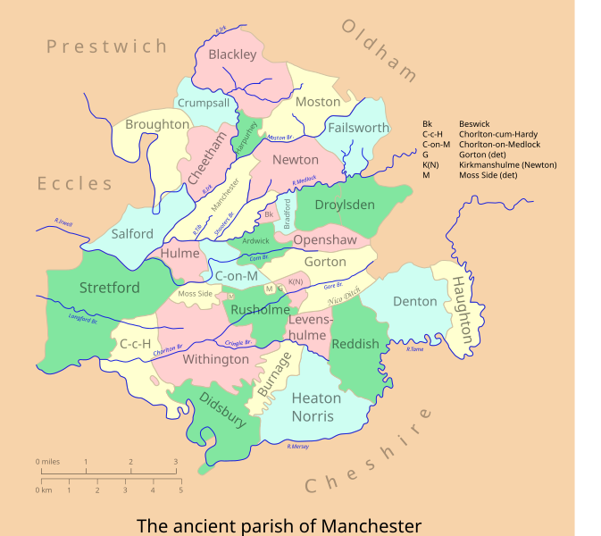
| Tuairisc | A vectorised & colorised version of the map at Farrer & Brownbill (1911), The Victoria history of the county of Lancaster. - Lancashire, Vol 4, p 175. |
| Dáta | |
| Foinse | Own work, after Farrer & Brownbill |
| Údar | Mr Stephen |
| Ceadúnas (Athúsáid a bhaint as an gcomhad seo) |
CC-BY-SA-2.5 |
Ceadúnú
Is mise sealbhóir cóipchirt an shaothair seo agus foilsím é faoin gceadúnas seo a leanas:
This file is licensed under the Creative Commons Attribution-Share Alike 2.5 Generic license.
- Is féidir:
- an saothar seo a roinnt – an saothar seo a chóipeáil, a dháil amach, agus a tharchur
- an saothar seo a athmheascadh – an saothar seo a oiriúnú
- Ach amháin má leantar na coinníollacha seo a leanas:
- sannadh – Ní mor creidiúint a thabhairt leis an saothar, faoi mar a shonraigh an údar nó tabharthóir an ceadúnais (ach ná húsáid modh a thugann le fios go thacaíonn sé/sí tú féin nó an úsáid a bhaineann tú as an saothar).
- comhroinn araon – Má athraíonn tú nó síneann tú amach an saothar seo, ní féidir é a dháileadh ach amhaín faoin gceadúnas céanna nó ceann cosúil leis an gceann seo.
Stair chomhaid
Cliceáil ar dáta/am chun an comhad a radharc mar a bhí sé ag an am sin.
| Dáta/Am | Mionsamhail | Toisí | Úsáideoir | Nóta tráchta | |
|---|---|---|---|---|---|
| faoi láthair | 23:15, 28 Eanáir 2007 | | 913 × 813 (246 KB) | Mr Stephen | {{Information |Description=A vectorised & colorised version of the map at Farrer & Brownbill (1911), The Victoria history of the county of Lancaster. - Lancashire, Vol 4, p 175. |Source=Own work, after Farrer & Brownbill |Date=Jan 2007 |Author=Mr Stephen |
| 23:10, 28 Eanáir 2007 |  | 913 × 813 (238 KB) | Mr Stephen | {{Information |Description=A vectorised & colorised version of the map at Farrer & Brownbill (1911), The Victoria history of the county of Lancaster. - Lancashire, Vol 4, p 175. |Source=Own work, after Farrer & Brownbill |Date=Jan 2007 |Author=Mr Stephen | |
| 22:59, 28 Eanáir 2007 |  | 913 × 813 (233 KB) | Mr Stephen | Reverted to earlier revision | |
| 22:57, 28 Eanáir 2007 |  | 913 × 813 (201 KB) | Mr Stephen | {{Information |Description=A vectorised & colorised version of the map at Farrer & Brownbill (1911), The Victoria history of the county of Lancaster. - Lancashire, Vol 4, p 175. |Source=Own work, after Farrer & Brownbill |Date=Jan 2007 |Author=Mr Stephen | |
| 23:10, 21 Eanáir 2007 |  | 913 × 813 (233 KB) | Mr Stephen | {{Information |Description=A vectorised & colorised version of the map at Farrer & Brownbill (1911), The Victoria history of the county of Lancaster. - Lancashire, Vol 4, p 175. |Source=Own work, after Farrer & Brownbill |Date=Jan 2007 |Author=Mr Stephen | |
| 22:56, 21 Eanáir 2007 |  | 744 × 1,052 (224 KB) | Mr Stephen | {{Information |Description=A vectorised & colorised version of the map at Farrer & Brownbill (1911), The Victoria history of the county of Lancaster. - Lancashire, Vol 4, p 175. |Source=Own work, after Farrer & Brownbill |Date=Jan 2007 |Author=Mr Stephen | |
| 22:31, 21 Eanáir 2007 |  | 744 × 1,052 (187 KB) | Mr Stephen | {{Information |Description=A vectorised & colorised version of the map at Farrer & Brownbill (1911), The Victoria history of the county of Lancaster. - Lancashire, Vol 4, p 175. |Source=Own work, after Farrer & Brownbill |Date=Jan 2007 |Author=Mr Stephen |
Úsáid comhaid
Níl nasc ó aon leathanach eile don íomhá seo.
Global file usage
The following other wikis use this file:
- Úsáid ar en.wikipedia.org
- Úsáid ar en.wiktionary.org