
Íomhá:Mallorca.jpg
Size of this preview: 785 × 599 picteilín. Other resolutions: 314 × 240 picteilín | 629 × 480 picteilín | 1,006 × 768 picteilín | 1,138 × 869 picteilín.
Taispeáin leagan ardtaifigh den íomhá (1,138 × 869 picteilín, méid comhaid: 164 KB, cineál MIME: image/jpeg)
| Seo comhad as An Cómhaoin Viciméid. Tá an tuairisc as an leathanach tuairisc Cómhaoin a leanas thíos.
|
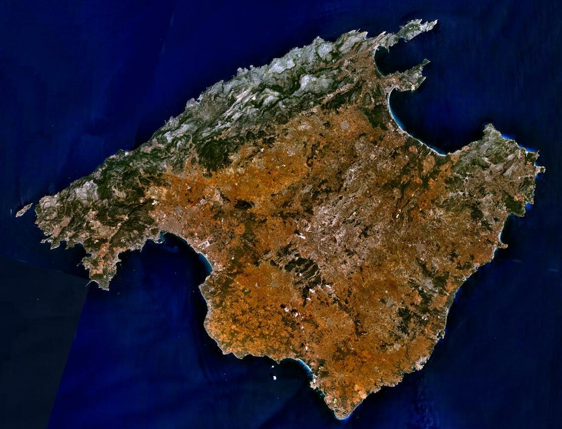
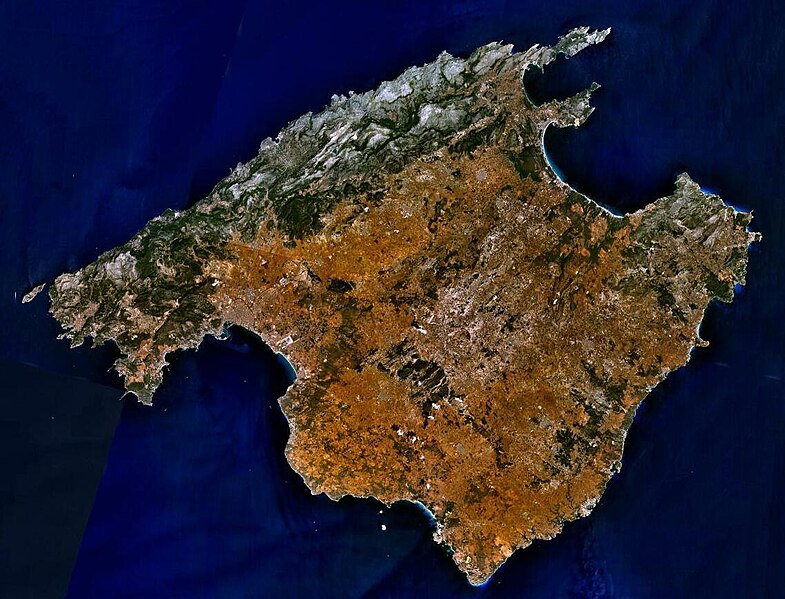
| Tuairisc | Sattelite image of Majorca |
| Foinse | NASA World Wind - Used Filter: "NTL Landsat7 (Visible Color)" |
| Údar | NASA |
| Ceadúnas (Athúsáid a bhaint as an gcomhad seo) |
"The Landsat Global Mosiac, Blue Marble, and the USGS raster maps and images are all Public Domain." (See http://www.worldwindcentral.com/wiki/Unofficial_FAQ#Are_images_on_World_Wind_copyrighted.3F |
| This image is in the public domain because it is a screenshot from NASA’s globe software World Wind using a public domain layer, such as Blue Marble, MODIS, Landsat, SRTM, USGS or GLOBE.
|
 |
Stair chomhaid
Cliceáil ar dáta/am chun an comhad a radharc mar a bhí sé ag an am sin.
| Dáta/Am | Mionsamhail | Toisí | Úsáideoir | Nóta tráchta | |
|---|---|---|---|---|---|
| faoi láthair | 17:19, 5 Meitheamh 2023 | | 1,138 × 869 (164 KB) | PalauanLibertarian | Cropped 11 % horizontally, 8 % vertically using CropTool with precise mode. |
| 19:31, 30 Nollaig 2012 |  | 1,280 × 944 (174 KB) | Rotatebot | Bot: Image rotated by 180° | |
| 09:16, 30 Nollaig 2012 |  | 1,280 × 944 (174 KB) | Rotatebot | Bot: Image rotated by 180° | |
| 08:29, 15 Bealtaine 2005 |  | 1,280 × 958 (175 KB) | Leipnizkeks | Sattelite image of Majorca - Source: NASA World Wind - Used Filter: "NTL Landsat7 (Visible Color)" - License: "The Landsat Global Mosiac, Blue Marble, and the USGS raster maps and images are all Public Domain." (See http://www.worldwindcentral.com/wiki/Un |
Úsáid comhaid
Tá nasc chuig an gcomhad seo ar 2 an leathanach seo a leanas:
Global file usage
The following other wikis use this file:
- Úsáid ar af.wikipedia.org
- Úsáid ar an.wikipedia.org
- Úsáid ar ar.wikipedia.org
- Úsáid ar arz.wikipedia.org
- Úsáid ar ast.wikipedia.org
- Úsáid ar az.wikipedia.org
- Úsáid ar be-tarask.wikipedia.org
- Úsáid ar be.wikipedia.org
- Úsáid ar bg.wikipedia.org
- Úsáid ar br.wikipedia.org
- Úsáid ar ca.wikipedia.org
- Illes Balears
- Mallorca
- Llista d'illes de la mar Mediterrània
- Portal:Illes Balears
- Portal:Illes Balears/Mallorca
- Plantilla:Distribució en les Illes Balears
- Usuari:Bilif
- Geografia dels Països Catalans
- Geografia de les Illes Balears
- Usuari:Aïda Lacomba Moreno
- Usuari:Maria quetglas
- Viquiprojecte:PESCAR/2018
- Viquiprojecte:PESCAR/seguiment 2018
- Úsáid ar ca.wikiquote.org
- Úsáid ar ceb.wikipedia.org
- Úsáid ar cs.wikipedia.org
- Úsáid ar cy.wikipedia.org
- Úsáid ar da.wikipedia.org
- Úsáid ar de.wikipedia.org
- Úsáid ar de.wikivoyage.org
- Úsáid ar de.wiktionary.org
- Úsáid ar el.wikipedia.org
- Úsáid ar en.wikipedia.org
View more global usage of this file.