
Íomhá:Locatie Medemblik.svg

Size of this PNG preview of this SVG file: 421 × 196 picteilín. Other resolutions: 320 × 149 picteilín | 640 × 298 picteilín | 1,024 × 477 picteilín | 1,280 × 596 picteilín | 2,560 × 1,192 picteilín.
Taispeáin leagan ardtaifigh den íomhá (Comhad SVG, ainmniúil 421 × 196 picteilíni, méid comhaid: 63 KB)
| Seo comhad as An Cómhaoin Viciméid. Tá an tuairisc as an leathanach tuairisc Cómhaoin a leanas thíos.
|
Achoimriú
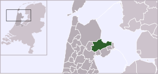
| Tuairisc | Locator map of municipality Medemblik (Netherlands) (from 2007) |
| Dáta | |
| Foinse | Own work, based on freely available GIS data |
| Údar | User:Mtcv |
| Ceadúnas (Athúsáid a bhaint as an gcomhad seo) |
Data: attribution required; my work: PD |
Ceadúnú

|
Ceadaíonn sealbhóir cóipcheart an chomhaid seo, Centraal Bureau voor de Statistiek, úsáid a bhaint as i gcomhair aidhm ar bith má aimnítear sealbhóir an chóipchirt. Is féidir é a athroinnt, obair díorthach a dhéanamh de, agus úsáid tráchtála a bhaint as, agus tá gach úsáid eile ceadaithe freisin. |
Creidiúint:
|
Stair chomhaid
Cliceáil ar dáta/am chun an comhad a radharc mar a bhí sé ag an am sin.
| Dáta/Am | Mionsamhail | Toisí | Úsáideoir | Nóta tráchta | |
|---|---|---|---|---|---|
| faoi láthair | 19:01, 3 Feabhra 2012 | | 421 × 196 (63 KB) | Gladiool | Same style as other maps + 2012 municipality borders |
| 13:24, 27 Eanáir 2011 |  | 840 × 450 (186 KB) | VYGOcommons | Medemblik after merger with Andijk and Wervershoof | |
| 01:09, 2 Eanáir 2007 |  | 840 × 450 (188 KB) | Mtcv | {{Information| |Description=Locator map of municipality Medemblik (Netherlands) (from 2007) |Source=Own work, based on freely available GIS data |Date=2007-01-02 |Author=User:Mtcv |Permission=Data: attribution required; my work: PD }} |
Úsáid comhaid
Níl nasc ó aon leathanach eile don íomhá seo.
Global file usage
The following other wikis use this file:
- Úsáid ar ar.wikipedia.org
- Úsáid ar br.wikipedia.org
- Úsáid ar fa.wikipedia.org
- Úsáid ar fr.wikipedia.org
- Úsáid ar lt.wikipedia.org
- Úsáid ar nl.wikivoyage.org
- Úsáid ar pt.wikipedia.org
- Úsáid ar ro.wikipedia.org
- Úsáid ar ru.wikipedia.org
- Úsáid ar sv.wikipedia.org
- Úsáid ar tr.wikipedia.org
- Úsáid ar ur.wikipedia.org
- Úsáid ar vi.wikipedia.org
- Úsáid ar www.wikidata.org
- Úsáid ar zh-min-nan.wikipedia.org