
Íomhá:Libya - Location Map (2013) - LBY - UNOCHA.svg

Taispeáin leagan ardtaifigh den íomhá (Comhad SVG, ainmniúil 253 × 252 picteilíni, méid comhaid: 1.53 MB)
| Seo comhad as An Cómhaoin Viciméid. Tá an tuairisc as an leathanach tuairisc Cómhaoin a leanas thíos.
|
_-_LBY_-_UNOCHA.svg)
Achoimriú
| Tuairisc |
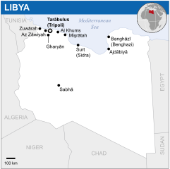
English: Locator map of Libya. |
| Dáta | |
| Foinse |
English: Libya Locator Map (ReliefWeb), ESRI, UNCS |
| Údar | |
| SVG genesis |
Ceadúnú
- Is féidir:
- an saothar seo a roinnt – an saothar seo a chóipeáil, a dháil amach, agus a tharchur
- an saothar seo a athmheascadh – an saothar seo a oiriúnú
- Ach amháin má leantar na coinníollacha seo a leanas:
- sannadh – Ní mor creidiúint a thabhairt leis an saothar, faoi mar a shonraigh an údar nó tabharthóir an ceadúnais (ach ná húsáid modh a thugann le fios go thacaíonn sé/sí tú féin nó an úsáid a bhaineann tú as an saothar).
 This map is part of a collection of 216 free country maps, created by the UN Office for the Coordination of Humanitarian Affairs (OCHA), to be used in print, web or broadcast products.
The ReliefWeb Location Maps released here are maps that highlight a country, its capital, major populated places and the surrounding regions. Attribution Requirements
Using the map without modifications: ensure that the sources and the disclaimer are below the map. Credit as follows: "Credit: OCHA". For use with alteration: remove the OCHA logo and disclaimer following any modification to the map, but keep the data sources as mentioned below the map. Credit the modified map as follows: "Based on OCHA map". You are responsible for the content of your map. We are keen to receive your feedback and hear how you used OCHA's maps. We would be grateful if you would notify us by e-mail and share your work with us. UN Disclaimer
The designations employed and the presentation of material of this map do not imply the expression of any opinion whatsoever on the part of the Secretariat of the United Nations concerning the legal status of any country, territory, city or area or of its authorities or concerning the delimitation of its frontiers or boundaries. |
Stair chomhaid
Cliceáil ar dáta/am chun an comhad a radharc mar a bhí sé ag an am sin.
| Dáta/Am | Mionsamhail | Toisí | Úsáideoir | Nóta tráchta | |
|---|---|---|---|---|---|
| faoi láthair | 03:52, 18 Samhain 2014 | | 253 × 252 (1.53 MB) | Pharos | try without logo for now |
| 20:16, 15 Iúil 2014 |  | 253 × 252 (259 KB) | Palmerop | User created page with UploadWizard |
Úsáid comhaid
Tá nasc chuig an gcomhad seo ar na leathanaigh seo a leanas:
Global file usage
The following other wikis use this file:
- Úsáid ar bh.wikipedia.org
- Úsáid ar bn.wikipedia.org
- Úsáid ar ca.wikipedia.org
- Úsáid ar fr.wikinews.org
- Úsáid ar gl.wikipedia.org
- Úsáid ar gu.wikipedia.org
- Úsáid ar ia.wikipedia.org
- Úsáid ar id.wikipedia.org
- Úsáid ar incubator.wikimedia.org
- Úsáid ar pl.wikipedia.org
- Úsáid ar sco.wikipedia.org
- Úsáid ar www.wikidata.org
_-_LBY_-_UNOCHA.svg)