
Íomhá:Last Glacial Maximum Vegetation Map.svg

Size of this PNG preview of this SVG file: 800 × 533 picteilín. Other resolutions: 320 × 213 picteilín | 640 × 427 picteilín | 1,024 × 683 picteilín | 1,280 × 853 picteilín | 2,560 × 1,707 picteilín | 1,200 × 800 picteilín.
Taispeáin leagan ardtaifigh den íomhá (Comhad SVG, ainmniúil 1,200 × 800 picteilíni, méid comhaid: 316 KB)
| Seo comhad as An Cómhaoin Viciméid. Tá an tuairisc as an leathanach tuairisc Cómhaoin a leanas thíos.
|
Achoimriú
| Tuairisc |
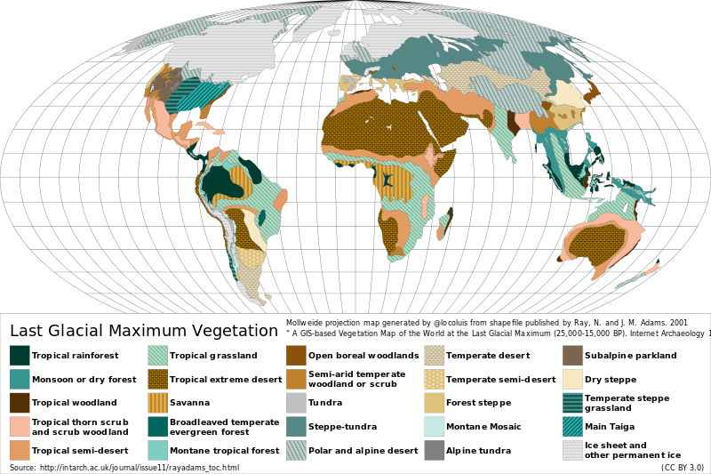
Español: Mapa de la vegetación durante el Último Máximo Glacial hace ~18.000 años atrás. English: Reconstructed vegetation cover at the Last Glacial Maximum period ~18,000 years ago, describing the type of vegetation cover present, based on fossil pollen samples recovered from lake and bog sediments. |
| Dáta | |
| Foinse |
Map generated from shapefile published by Ray, N. and J. M. Adams. 2001, “ A GIS-based Vegetation Map of the World at the Last Glacial Maximum (25,000-15,000 BP). Internet Archaeology 11. ” Source: http://intarch.ac.uk/journal/issue11/rayadams_toc.html |
| Údar | Locoluis |
| English | Spanish |
|---|---|
| Tropical rainforest | Selva tropical |
| Monsoon or dry forest | Monzón o bosque seco |
| Tropical woodland | Sabana arbolada tropical |
| Tropical thorn scrub and scrub woodland | Matorral espinoso tropical y bosque de matorral |
| Tropical semi-desert | Semi-desierto tropical |
| Tropical grassland | Pradera tropical |
| Tropical extreme desert | Desierto extremo tropical |
| Savanna | Sabana |
| Broadleaved temperate evergreen forest | Bosque siempreverde templado de hojas anchas |
| Montane tropical forest | Bosque tropical montano |
| Open boreal woodlands | Bosque boreal abierto |
| Semi-arid temperate woodland or scrub | Sabana arbolada o matorral templado semi-árido |
| Tundra | Tundra |
| Steppe-tundra | Estepa-tundra |
| Polar and alpine desert | Desierto polar y alpino |
| Temperate desert | Desierto templado |
| Temperate semi-desert | Semi-desierto templado |
| Forest steppe | Bosque estepa |
| Montane mosaic | Mosaico montano |
| Alpine tundra | Tundra alpina |
| Subalpine parkland | Zona verde subalpina |
| Dry steppe | Estepa seca |
| Temperate steppe grassland | Pastizal de estepa templada |
| Main Taiga | Taiga principal |
| Ice sheet and other permanent ice | Campos de hielo y otro hielos permanentes |
Ceadúnú
This file is licensed under the Creative Commons Attribution 3.0 Unported license.
- Is féidir:
- an saothar seo a roinnt – an saothar seo a chóipeáil, a dháil amach, agus a tharchur
- an saothar seo a athmheascadh – an saothar seo a oiriúnú
- Ach amháin má leantar na coinníollacha seo a leanas:
- sannadh – Ní mor creidiúint a thabhairt leis an saothar, faoi mar a shonraigh an údar nó tabharthóir an ceadúnais (ach ná húsáid modh a thugann le fios go thacaíonn sé/sí tú féin nó an úsáid a bhaineann tú as an saothar).
Stair chomhaid
Cliceáil ar dáta/am chun an comhad a radharc mar a bhí sé ag an am sin.
| Dáta/Am | Mionsamhail | Toisí | Úsáideoir | Nóta tráchta | |
|---|---|---|---|---|---|
| faoi láthair | 02:12, 23 Lúnasa 2015 | | 1,200 × 800 (316 KB) | Locoluis | Minor font adjustments. Typo in original source. |
| 02:01, 23 Lúnasa 2015 |  | 1,200 × 800 (316 KB) | Locoluis | User created page with UploadWizard |
Úsáid comhaid
Tá nasc chuig an gcomhad seo ar na leathanaigh seo a leanas:
Global file usage
The following other wikis use this file:
- Úsáid ar als.wikipedia.org
- Úsáid ar ar.wikipedia.org
- Úsáid ar bcl.wikipedia.org
- Úsáid ar be.wikipedia.org
- Úsáid ar ca.wikipedia.org
- Úsáid ar cs.wikipedia.org
- Úsáid ar da.wikipedia.org
- Úsáid ar de.wikipedia.org
- Úsáid ar el.wikipedia.org
- Úsáid ar en.wikipedia.org
- Úsáid ar es.wikipedia.org
- Úsáid ar fr.wikipedia.org
- Úsáid ar fy.wikipedia.org
- Úsáid ar hy.wikipedia.org
- Úsáid ar it.wikipedia.org
- Úsáid ar ja.wikipedia.org
- Úsáid ar la.wikipedia.org
- Úsáid ar mk.wikipedia.org
- Úsáid ar nn.wikipedia.org
View more global usage of this file.