
Íomhá:Kirk Braddan Old Church - geograph.org.uk - 24358.jpg
Níl aon taifeach is mó ar fáil.
Kirk_Braddan_Old_Church_-_geograph.org.uk_-_24358.jpg (640 × 427 picteilín, méid comhaid: 92 KB, cineál MIME: image/jpeg)
| Seo comhad as An Cómhaoin Viciméid. Tá an tuairisc as an leathanach tuairisc Cómhaoin a leanas thíos.
|
Achoimriú
| Tuairisc |
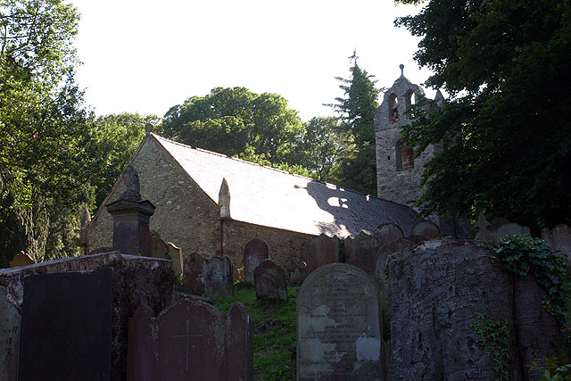
English: Kirk Braddan Old Church. The mother church of Douglas set in a beautiful wooded valley by the River Dhoo. The churchyard is full of Georgian head-stones and dominated by an obelisk designed by Steuart to Lord Henry Murray. Tower, 1773. Interior high pews, galleries, clear glass and monuments on walls.[JB]
Built 1773 following presentations that the roof and gable of the previous church were unsafe and also after complaints that the previous church was too small. The received wisdom is that the old church was demolished and the new built from the reclaimed rubble though with quoins of Foxdale granite. However recent surveys by Mr F. Cowin have convinced him that although the east end was demolished and rebuilt and the tower added, the remaining walls are mostly the original dating from the twelfth century. Following the precedent of St Marks (b 1772) the four corners were marked by pinnacles. Unlike many other island churches it was probably never whitewashed. |
| Dáta | |
| Foinse | From geograph.org.uk |
| Údar | Andy Stephenson |
| Creidiúint (required by the license) | Andy Stephenson / Kirk Braddan Old Church / |
| Object location | | View this and other nearby images on: OpenStreetMap |
|---|
_&language=ga)
Ceadúnú

|
This image was taken from the Geograph project collection. See this photograph's page on the Geograph website for the photographer's contact details. The copyright on this image is owned by Andy Stephenson and is licensed for reuse under the Creative Commons Attribution-ShareAlike 2.0 license.
|
This file is licensed under the Creative Commons Attribution-Share Alike 2.0 Generic license.
Creidiúint: Andy Stephenson
- Is féidir:
- an saothar seo a roinnt – an saothar seo a chóipeáil, a dháil amach, agus a tharchur
- an saothar seo a athmheascadh – an saothar seo a oiriúnú
- Ach amháin má leantar na coinníollacha seo a leanas:
- sannadh – Ní mor creidiúint a thabhairt leis an saothar, faoi mar a shonraigh an údar nó tabharthóir an ceadúnais (ach ná húsáid modh a thugann le fios go thacaíonn sé/sí tú féin nó an úsáid a bhaineann tú as an saothar).
- comhroinn araon – Má athraíonn tú nó síneann tú amach an saothar seo, ní féidir é a dháileadh ach amhaín faoin gceadúnas céanna nó ceann cosúil leis an gceann seo.
Stair chomhaid
Cliceáil ar dáta/am chun an comhad a radharc mar a bhí sé ag an am sin.
| Dáta/Am | Mionsamhail | Toisí | Úsáideoir | Nóta tráchta | |
|---|---|---|---|---|---|
| faoi láthair | 03:32, 30 Eanáir 2010 | | 640 × 427 (92 KB) | GeographBot | == {{int:filedesc}} == {{Information |description={{en|1=Kirk Braddan Old Church. The mother church of Douglas set in a beautiful wooded valley by the River Dhoo. The churchyard is full of Georgian head-stones and dominated by an obelisk designed by Steua |
Úsáid comhaid
Níl nasc ó aon leathanach eile don íomhá seo.
Global file usage
The following other wikis use this file:
- Úsáid ar arz.wikipedia.org
- Úsáid ar de.wikipedia.org
- Úsáid ar en.wikipedia.org
- Úsáid ar fr.wikipedia.org
- Úsáid ar gv.wikipedia.org
- Úsáid ar nl.wikipedia.org
- Úsáid ar ru.wikipedia.org
- Úsáid ar sk.wikipedia.org
- Úsáid ar www.wikidata.org