
Íomhá:Irland karte.png
Size of this preview: 503 × 600 picteilín. Other resolutions: 201 × 240 picteilín | 402 × 480 picteilín | 644 × 768 picteilín | 858 × 1,024 picteilín | 1,473 × 1,757 picteilín.
Taispeáin leagan ardtaifigh den íomhá (1,473 × 1,757 picteilín, méid comhaid: 1.25 MB, cineál MIME: image/png)
| Seo comhad as An Cómhaoin Viciméid. Tá an tuairisc as an leathanach tuairisc Cómhaoin a leanas thíos.
|
|
| Tuairisc |
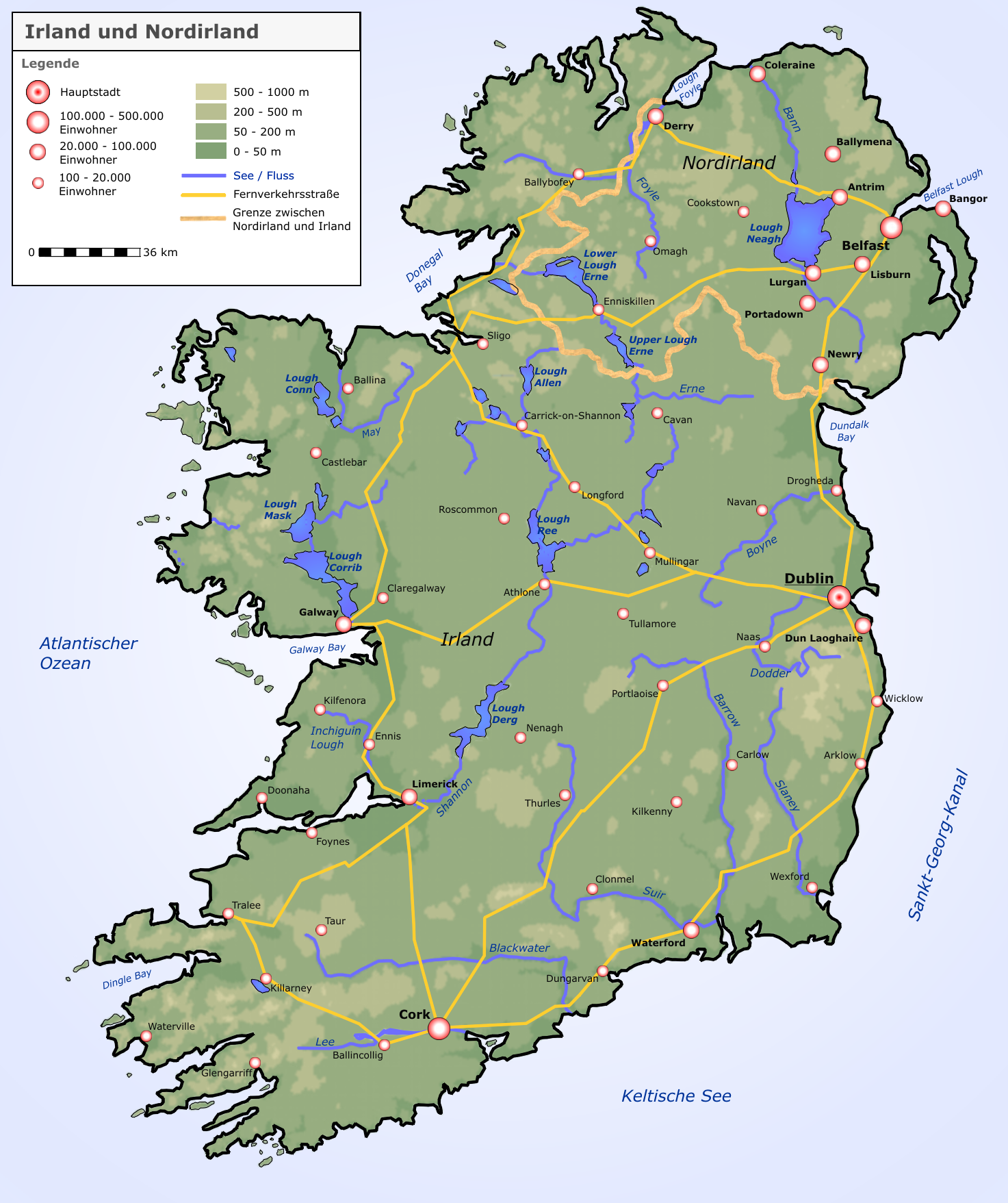
Deutsch: Neue Karte von Irland und Nordirland |
| Dáta | |
| Foinse |
selbst erstellt von Roger Zenner
|
| Údar | Roger Zenner |
| Ceadúnas (Athúsáid a bhaint as an gcomhad seo) |
CC-by-sa-2.0-de |
| Leaganacha eile |
copied from de.wikipedia [1]:
|
![[1]](https://de.wikipedia.org/wiki/Bild:Irland_karte.png)
This file is licensed under the Creative Commons Attribution-Share Alike 2.0 Germany license.
- Is féidir:
- an saothar seo a roinnt – an saothar seo a chóipeáil, a dháil amach, agus a tharchur
- an saothar seo a athmheascadh – an saothar seo a oiriúnú
- Ach amháin má leantar na coinníollacha seo a leanas:
- sannadh – Ní mor creidiúint a thabhairt leis an saothar, faoi mar a shonraigh an údar nó tabharthóir an ceadúnais (ach ná húsáid modh a thugann le fios go thacaíonn sé/sí tú féin nó an úsáid a bhaineann tú as an saothar).
- comhroinn araon – Má athraíonn tú nó síneann tú amach an saothar seo, ní féidir é a dháileadh ach amhaín faoin gceadúnas céanna nó ceann cosúil leis an gceann seo.


|
This map image could be re-created using vector graphics as an SVG file. This has several advantages; see Commons:Media for cleanup for more information. If an SVG form of this image is available, please upload it and afterwards replace this template with
{{vector version available|new image name}}.
It is recommended to name the SVG file “Irland karte.svg”—then the template Vector version available (or Vva) does not need the new image name parameter. |
Stair chomhaid
Cliceáil ar dáta/am chun an comhad a radharc mar a bhí sé ag an am sin.
| Dáta/Am | Mionsamhail | Toisí | Úsáideoir | Nóta tráchta | |
|---|---|---|---|---|---|
| faoi láthair | 09:05, 17 Meán Fómhair 2005 | | 1,473 × 1,757 (1.25 MB) | Saperaud~commonswiki | neue Karte von Irland und Nordirland Lizenz: Das Bild wurde von Benutzer:Roger_Zenner gezeichnet und wurde unter der CC-by-sa/2.0/de veröffentlicht. *Version 1.6: Höhenstufen weicher *Version 1.5: Londonderry heißt nun Derry, Beschriftungen angep |
Úsáid comhaid
Tá nasc chuig an gcomhad seo ar na leathanaigh seo a leanas:
Global file usage
The following other wikis use this file:
- Úsáid ar ar.wikipedia.org
- Úsáid ar ca.wikipedia.org
- Úsáid ar cs.wikipedia.org
- Úsáid ar da.wikipedia.org
- Úsáid ar de.wikipedia.org
- Irland (Insel)
- Irland
- Wikipedia:Kandidaten für exzellente Bilder/Archiv2004/4
- Benutzer:Roger Zenner/Bilder
- Datei:Irland karte.png
- Benutzer:Cmoder/Grafiktipps
- Wikipedia:Exzellente Bilder/Karten und Satellitenbilder
- Benutzer:Uwe Dedering/Länderliste
- Benutzer:Ulflulfl/Karten
- Vorlage:Infobox Insel/Erprobung Karte in einer Ecke
- Vorlage:Infobox Insel/Erprobung Karte in einer Ecke/Doku
- Úsáid ar de.wiktionary.org
- Úsáid ar eo.wikipedia.org
- Úsáid ar et.wikipedia.org
- Úsáid ar frr.wikipedia.org
- Úsáid ar fr.wikipedia.org
- Úsáid ar hy.wikipedia.org
- Úsáid ar kab.wikipedia.org
- Úsáid ar lb.wikipedia.org
- Úsáid ar pfl.wikipedia.org
- Úsáid ar pl.wikipedia.org
- Shannon (rzeka)
- Geografia Irlandii
- Boyne
- Lee (rzeka w Irlandii)
- Wikipedysta:DodekBot/lista-de
- Wikipedysta:DodekBot/lista-de2
- Corrib
- Liffey
- Blackwater (Meath)
- Slaney
- Munster Blackwater
- Barrow (rzeka)
- Brosna (rzeka)
- Suir
- Nore
- Erne
- Camac
- Tolka
- Dodder
- Mulkear
- Laune
- Blackwater (Kerry)
- Blackwater (Ulster)
- Finn (rzeka)
- Feale
View more global usage of this file.