
Íomhá:IBCAO betamap.jpg
Size of this preview: 526 × 599 picteilín. Other resolutions: 211 × 240 picteilín | 421 × 480 picteilín | 762 × 868 picteilín.
Taispeáin leagan ardtaifigh den íomhá (762 × 868 picteilín, méid comhaid: 710 KB, cineál MIME: image/jpeg)
| Seo comhad as An Cómhaoin Viciméid. Tá an tuairisc as an leathanach tuairisc Cómhaoin a leanas thíos.
|
| Cur síos |
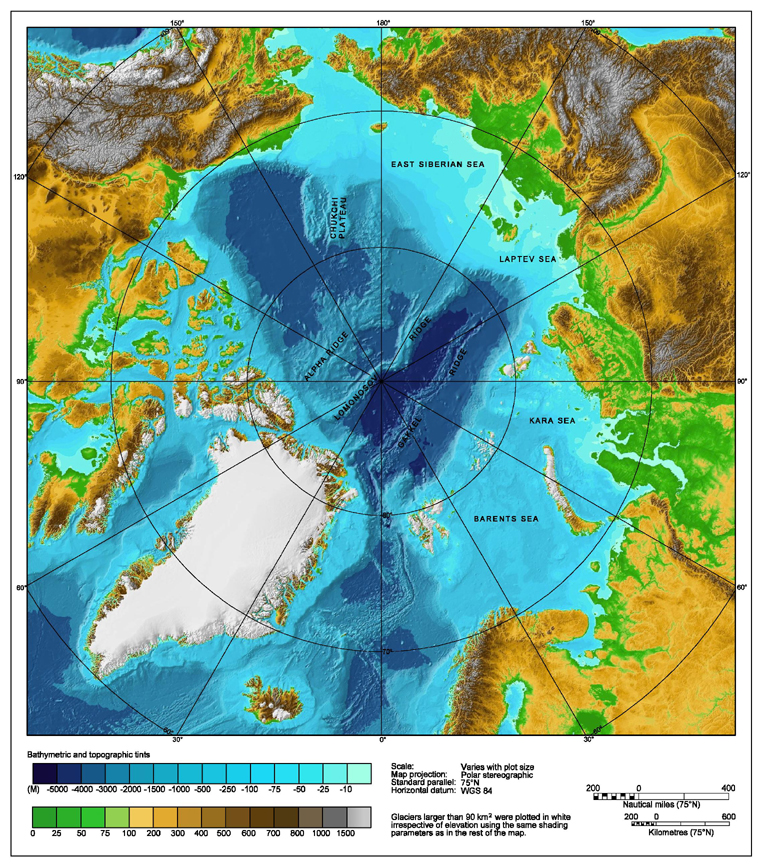
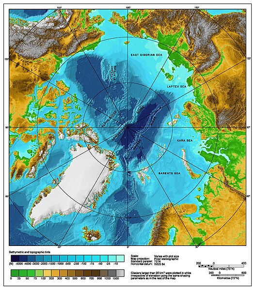
Bathymetric map of the Arctic Ocean |
|||||||||
| Foinse | http://www.ngdc.noaa.gov/mgg/image/IBCAO_betamap.jpg | |||||||||
| Ceadúnas (Athúsáid a bhaint as an gcomhad seo) |
|
|||||||||
| Geotemporal data | ||||||||||
| Bounding box |
|
|||||||||
| Georeferencing | ||||||||||
| Leaganacha eile |
Derivative works of this file: |
|||||||||
Stair chomhaid
Cliceáil ar dáta/am chun an comhad a radharc mar a bhí sé ag an am sin.
| Dáta/Am | Mionsamhail | Toisí | Úsáideoir | Nóta tráchta | |
|---|---|---|---|---|---|
| faoi láthair | 00:29, 2 Lúnasa 2007 | | 762 × 868 (710 KB) | Mikkalai | Source: http://www.ngdc.noaa.gov/mgg/image/IBCAO_betamap.jpg Bathymetric map of the w:Arctic Ocean |
Úsáid comhaid
Níl nasc ó aon leathanach eile don íomhá seo.
Global file usage
The following other wikis use this file:
- Úsáid ar af.wikipedia.org
- Úsáid ar ar.wikipedia.org
- Úsáid ar ary.wikipedia.org
- Úsáid ar ast.wikipedia.org
- Úsáid ar avk.wikipedia.org
- Úsáid ar azb.wikipedia.org
- Úsáid ar bcl.wikipedia.org
- Úsáid ar be.wikipedia.org
- Úsáid ar bg.wikipedia.org
- Úsáid ar bh.wikipedia.org
- Úsáid ar bn.wikipedia.org
- Úsáid ar bxr.wikipedia.org
- Úsáid ar ca.wikipedia.org
- Úsáid ar ceb.wikipedia.org
- Úsáid ar chr.wikipedia.org
- Úsáid ar co.wikipedia.org
- Úsáid ar crh.wikipedia.org
- Úsáid ar cs.wikipedia.org
- Úsáid ar da.wikipedia.org
- Úsáid ar de.wikipedia.org
- Úsáid ar dty.wikipedia.org
- Úsáid ar en.wikipedia.org
- Talk:Lomonosov Ridge
- Territorial claims in the Arctic
- Arktika 2007
- Portal:Maps/Maps/Geographic
- Portal:Maps/Maps/Geographic/2
- Arctic Ocean
- User:Wiki User 68/My Portal/Selected geography/1
- List of Russian explorers
- Wikipedia:Reference desk/Archives/Science/2015 May 29
- User:Joelton Ivson/Gather lists/24441 – Conflitos internacionais
- Portal:Oceans
- Úsáid ar en.wikinews.org
- Úsáid ar en.wikiversity.org
- Úsáid ar eo.wikipedia.org
- Úsáid ar es.wikipedia.org
View more global usage of this file.