
Íomhá:Haitian national palace earthquake.jpg

Size of this preview: 800 × 533 picteilín. Other resolutions: 320 × 213 picteilín | 640 × 427 picteilín | 1,024 × 683 picteilín | 1,280 × 853 picteilín | 3,000 × 2,000 picteilín.
Taispeáin leagan ardtaifigh den íomhá (3,000 × 2,000 picteilín, méid comhaid: 1.82 MB, cineál MIME: image/jpeg)
| Seo comhad as An Cómhaoin Viciméid. Tá an tuairisc as an leathanach tuairisc Cómhaoin a leanas thíos.
|
Achoimriú
| Tuairisc |
Català: El Palau Nacional d'Haití greument danyat després del terratrèmol del 12 de gener del 2010. Port-au-Prince, Haití. Nota: aquest edifici era de dos plantes; la segona planta es va esfondrar completament.
Deutsch: Der Haitianische Nationalpalast (Präsidentenpalast), in Port-au-Prince, Haiti. Beachte: es handelt sich um ein zweistöckiges Gebäude, das zweite Stockwerk ist vollständig eingestürzt.
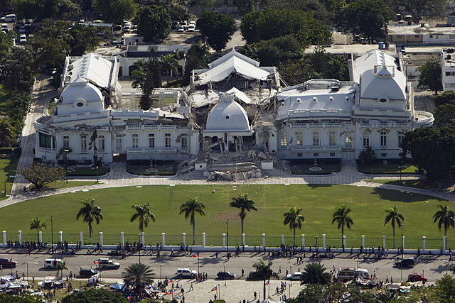
English: The Haitian National Palace (Presidential Palace), located in Port-au-Prince, Haiti, heavily damaged after the earthquake of January 12, 2010. Note: this was originally a two-story structure; the second story completely collapsed.
Español: El Palacio Nacional de Haití (Palacio Presidencial) severamente dañado tras el terremoto del 12 de enero de 2010. Port-au-Prince, Haití. Nota: este edificio era de dos plantas; el segundo piso se hundió completamente.
Suomi: Haitin presidentinpalatsi pahasti vaurioituneena 12. tammikuuta 2010 tapahtuneen maanjäristyksen jälkeen. Port-au-Prince, Haiti.
Français : Le Palais national sévèrement endommagé après le séisme du 12 janvier 2010 à Port-au-Prince, Haiti. A noter : il s'agit d'un bâtiment à deux étages, le deuxième étage s'est complèment effondré.
Italiano: Il Palazzo presidenziale di Haiti (Palazzo presidenziale) pesantemente danneggiato dopo il terremoto del 12 Gennaio 2010 a Port-au-Prince, Haiti. Nota: la struttura era originariamente a due piani; il secondo piano è collassato completamente. |
||||
| Dáta | |||||
| Foinse | United Nations Development Programme, originally posted to Flickr as Haiti Earthquake | ||||
| Údar | Logan Abassi / UNDP Global | ||||
| Ceadúnas (Athúsáid a bhaint as an gcomhad seo) |
|
||||
| Leaganacha eile |
Derivative works of this file: Haitian national palace earthquake-edit.jpg
|


| Object location | | View this and other nearby images on: OpenStreetMap |
|---|
|
Ceadúnú
This file is licensed under the Creative Commons Attribution 2.0 Generic license.
- Is féidir:
- an saothar seo a roinnt – an saothar seo a chóipeáil, a dháil amach, agus a tharchur
- an saothar seo a athmheascadh – an saothar seo a oiriúnú
- Ach amháin má leantar na coinníollacha seo a leanas:
- sannadh – Ní mor creidiúint a thabhairt leis an saothar, faoi mar a shonraigh an údar nó tabharthóir an ceadúnais (ach ná húsáid modh a thugann le fios go thacaíonn sé/sí tú féin nó an úsáid a bhaineann tú as an saothar).
Stair chomhaid
Cliceáil ar dáta/am chun an comhad a radharc mar a bhí sé ag an am sin.
| Dáta/Am | Mionsamhail | Toisí | Úsáideoir | Nóta tráchta | |
|---|---|---|---|---|---|
| faoi láthair | 18:18, 14 Eanáir 2010 | | 3,000 × 2,000 (1.82 MB) | Flickr upload bot | Uploaded from http://flickr.com/photo/37913760@N03/4274663582 using Flickr upload bot |
Úsáid comhaid
Níl nasc ó aon leathanach eile don íomhá seo.
Global file usage
The following other wikis use this file:
- Úsáid ar ar.wikipedia.org
- Úsáid ar arz.wikipedia.org
- Úsáid ar ast.wikipedia.org
- Úsáid ar bg.wikinews.org
- Úsáid ar ca.wikipedia.org
- Úsáid ar ckb.wikipedia.org
- Úsáid ar cs.wikipedia.org
- Úsáid ar da.wikipedia.org
- Jordskælvet i Haiti 2010
- Hédi Annabi
- Zilda Arns
- Skabelon:Navboks Jordskælvet i Haiti 2010
- Port-au-Prince (arrondissement)
- Christopher Hotel
- Léogâne
- Georges Anglade
- Carrefour (Haiti)
- Luiz Carlos da Costa
- Joseph Serge Miot
- Michel Gaillard
- Sam Dixon
- Jimmy O
- Hôtel Montana
- Gressier
- Delmas (Haiti)
- Præsidentpaladset (Haiti)
- Úsáid ar de.wikipedia.org
- Úsáid ar en.wikipedia.org
View more global usage of this file.