Íomhá:Europe map 1919.jpg
Page contents not supported in other languages.
Ón Vicipéid, an chiclipéid shaor.

Taispeáin leagan ardtaifigh den íomhá(1,920 × 1,440 picteilín, méid comhaid: 1.41 MB, cineál MIME: image/jpeg)

Seo comhad as An Cómhaoin Viciméid. Tá an tuairisc as an leathanach tuairisc Cómhaoin a leanas thíos.
Is stór comhaid meáin Saor é an Cómhaoin Viciméid. Is féidir leat cabhrú.

Achoimriú

Tuairisc
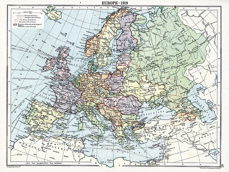
English: Map of en:Europe political divisions in 1919 (after the treaties of Brest-Litovsk and Versailles and before the treaties of Trianon, Riga, Kars and the establishment of en:Soviet Union and the republics of Ireland and Turkey) published by London Geographical Institute. This uploaded map is a photoshopped version of the original image located at hipkiss.org. According to the site, there are no copyrights to this map.
Foinse
Údar
Leaganacha eile Derivative works of this file:  Europe map 1919 cropped.JPG
Maps of the history of Europe
BCE
aC

Weichselian ice age (c. 113,000–9700) · Neolithic expansion (c. 7000–4500) · Middle Neolithic (c. 4500–4000) · Late Neolithic (c. 4000–3000) · Copper Age – Corded Ware culture (c. 2900–2350) · Copper Age – Bellbeaker culture (c. 2800–1800) · Early Bronze Age – Unetice culture (c. 2300–1600) · Late Bronze Age – Urnfield culture (c. 1300—750) · Migrations (c. 1000–100) · Hallstatt & La Tène cultures (c. 800–100) · Roman Republic (510–40) · 220 · 218 · 200 · 201–100 · 58 · 49 · 39 · 30 BCE–6 CE


CE
dC

14 · 14–37 · 60 · 60 · 69 · 80 · Migrations 100–500 · 117 · 117 · 125 · Migrations 150–774 · Economy 180 · 271 · 293–305 · 337 · 395 · c. 395 · 400 · 400 · 450 · 457–61 · 476 · 480 · Franks 481–814 · Early Slavs 500–700 · 500 · 526 · 526–600 · Christianisation to 600 · c. 550 · 650 · Pontic Steppe 650 · 665 · 800 · Vikings 800–1050 · 814 · 843–70 · 850 · 900 · 912 · 998 · 1000 · 1000 · 1054 · 1092 · First Crusade 1095–99 · 1097 · 1135 · 1142 · 1147–49 · 1190 · 1190 · 1250 · c. 1250 · 1301-1400 · 1301-1400 · 1328 · 1345 · Black Plague 1347–51 · 1360 · 1400 · Trade routes c. 1400 · 1430 · 1470 · 1490 · 1492 · 1500 · 1519 · 1550 · 1560 · Religion 1560 · Religion 1600 · Religion 1618 · 1618–48 · 1648 · 1683 · 1700 · 1701 · 1708 · 1714 · 1721 · 1725–30 · 1739–1740 · 1740 · 1748–66 · 1783–1792 · 1787 · 1787 · 1789 · 1799 · 1812 · 1812 · 1812 · 1812 · 1813 · 1815 · 1815 · 1815 · 1818 · Ottoman Empire 1830–1923 · 1848–49 · 1861 · 1867 · 1871 · 1878 · 1890 · 1905 · 1911 · 1914 · 1914 · 1919 · 1919–29 · 1923 · 1929 · 1930 · 1940 · 1941–42 · 1942–45 · Cold War 1947–91 · 1950 · 1993–2006 · 2006 to date

(this template: · view · discuss )

Ceadúnú

Public domain
Public domain
I Stáit Aontaithe Mheiriceá, tá an chomhad méide seo sa bhfearann poiblí. Ciallaíonn sé seo go bhfoilsíodh don chéad uair an íomhá seo i Stáit Aontaithe Meiriceá roimh an 1 Eanáir 1929. Féach ar an leathanach seo le tuilleadh eolais.

United States
United States
B'fhéidir go bhfuil rialacha eile i bhfeidhm i limistéir údaráis eile, agus b'fhéidir nach bhfuil an íomhá seo sa bhfearann poiblí lasmuigh de Stáit Aontaithe Mhericeá.

Original upload log

The original description page was here. All following user names refer to en.wikipedia.
  • 2007-11-03 20:09 MaGioZal 1996×1506×8 (1457003 bytes) Map of [[Europe]] political divisions in 1919 (after the treaties of [[Treaty_of_Brest-Litovsk|Brest-Livotsk]] and [[Treaty of Versailles|Versailles]] and before the [[Treaty of Riga]] and the creation of [[Soviet Union]]) published by London Geographical

Captions

Add a one-line explanation of what this file represents
The situation in Europe after WW1. Several new states were born such as Ukraine(the country in Yellow at the North of the Black Sea)

Items portrayed in this file

taispeánann sé/sí

MIME type Béarla

image/jpeg

Stair chomhaid

Cliceáil ar dáta/am chun an comhad a radharc mar a bhí sé ag an am sin.

Dáta/AmMionsamhailToisíÚsáideoirNóta tráchta
faoi láthair05:41, 7 Lúnasa 2023Mionsamhail do leagan ó 05:41, 7 Lúnasa 20231,920 × 1,440 (1.41 MB)User-duckCropped to reduce border using CropTool with lossless mode.
23:29, 22 Aibreán 2008Mionsamhail do leagan ó 23:29, 22 Aibreán 20081,996 × 1,506 (1.39 MB)File Upload Bot (Magnus Manske) {{BotMoveToCommons|en.wikipedia}} {{Information |Description={{en|Map of en:Europe political divisions in 1919 (after the treaties of Brest-Livotsk and Versailles and before the treaties o

Tá nasc chuig an gcomhad seo ar na leathanaigh seo a leanas:

Global file usage

The following other wikis use this file:

View more global usage of this file.