
Íomhá:Europe -50.png

Size of this preview: 800 × 554 picteilín. Other resolutions: 320 × 222 picteilín | 640 × 444 picteilín | 1,024 × 710 picteilín | 1,280 × 887 picteilín | 1,704 × 1,181 picteilín.
Taispeáin leagan ardtaifigh den íomhá (1,704 × 1,181 picteilín, méid comhaid: 1.99 MB, cineál MIME: image/png)
| Seo comhad as An Cómhaoin Viciméid. Tá an tuairisc as an leathanach tuairisc Cómhaoin a leanas thíos.
|
Achoimriú
| Tuairisc |
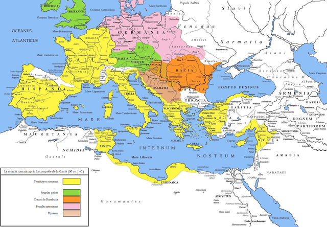
Deutsch: Das Römische Reich im Jahr 50 v. Chr. vor dem Beginn des Bürgerkriegs.
English: The Roman world in 50 BC, after Gallia's conquest by Caesar. (Note: Map doesn't show subordinate Roman client kingdoms in Anatolia and the Levant.) |
| Dáta | 28-10-2007 / 10-10-2008 |
| Foinse | Obair féin |
| Údar | Cristiano64 / Coldeel |
| Ceadúnas (Athúsáid a bhaint as an gcomhad seo) |
Cristiano64 |
| Leaganacha eile |
Italiano:  |
Ceadúnú
Is mise sealbhóir cóipchirt an shaothair seo agus foilsím é faoin gceadúnas seo a leanas:

|
Tugtar cead an doiciméad seo a chóipeáil, a dháileadh agus/nó a mhodhnú faoi théarmaí an Ceadúnas Doiciméadúcháin Saor ó GNU, Leagan 1.2 nó aon leagan níos déanaí a d’fhoilsigh an Fondúireacht Bogearraí Saor in Aisce; gan aon Rannóga Inmheánacha, gan aon Téacsanna Clúdaigh Tosaigh, agus gan aon Téacsanna Clúdaigh Cúil. Tá cóip den cheadúnas san áireamh sa chuid dar teideal Ceadúnas Doiciméadúcháin Saor ó GNU. |
| This file is licensed under the Creative Commons Attribution-Share Alike 3.0 Unported license. | ||
| ||
| This licensing tag was added to this file as part of the GFDL licensing update. |
Stair chomhaid
Cliceáil ar dáta/am chun an comhad a radharc mar a bhí sé ag an am sin.
| Dáta/Am | Mionsamhail | Toisí | Úsáideoir | Nóta tráchta | |
|---|---|---|---|---|---|
| faoi láthair | 09:23, 10 Deireadh Fómhair 2008 | | 1,704 × 1,181 (1.99 MB) | Coldeel | == Description == {{Information |Description=The Roman world in 50 BC, after Gallia's conquest by Caesar. (Note: Map doesn't show subordinate Roman client kingdoms in Anatolia and the Levant.) |Source=self-made |Date=28-10-2007 / 10-10-2008 |Author= [[Use |
| 09:14, 10 Deireadh Fómhair 2008 |  | 1,704 × 1,181 (2 MB) | Coldeel | == Description == {{Information |Description=The Roman world in 50 BC, after Gallia's conquest by Caesar. (Note: Map doesn't show subordinate Roman client kingdoms in Anatolia and the Levant.) |Source=self-made |Date=28-10-2007 / 10-10-2008 |Author= [[Use |
Úsáid comhaid
Tá nasc chuig an gcomhad seo ar na leathanaigh seo a leanas:
Global file usage
The following other wikis use this file:
- Úsáid ar azb.wikipedia.org
- Úsáid ar de.wikipedia.org
- Úsáid ar en.wikipedia.org
- Úsáid ar fr.wikipedia.org
- Úsáid ar ka.wikipedia.org
- Úsáid ar nl.wikipedia.org
- Úsáid ar pt.wikipedia.org