
Íomhá:Dublin 1901 NE B.png

Taispeáin leagan ardtaifigh den íomhá (876 × 640 picteilín, méid comhaid: 369 KB, cineál MIME: image/png)
| Seo comhad as An Cómhaoin Viciméid. Tá an tuairisc as an leathanach tuairisc Cómhaoin a leanas thíos.
|
Achoimriú
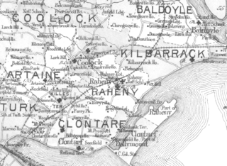
| Tuairisc | Dublin and north-eastern suburbs, with formal civic boundaries as at 1901 |
| Dáta | |
| Foinse | Richards Memorial Atlas |
| Údar | L J Richards |
| Ceadúnas (Athúsáid a bhaint as an gcomhad seo) |
Public domain (all USA pre-1923) |
Ceadúnú
|
This work is in the public domain in its country of origin and other countries and areas where the copyright term is the author's life plus 70 years or fewer.
| |
| This file has been identified as being free of known restrictions under copyright law, including all related and neighboring rights. | |
Stair chomhaid
Cliceáil ar dáta/am chun an comhad a radharc mar a bhí sé ag an am sin.
| Dáta/Am | Mionsamhail | Toisí | Úsáideoir | Nóta tráchta | |
|---|---|---|---|---|---|
| faoi láthair | 12:08, 31 Márta 2007 | | 876 × 640 (369 KB) | Rahenj | {{Information |Description = Dublin and north-eastern suburbs, with formal civic boundaries as at 1901 |Source = Richards Memorial Atlas |Date = 1901 |Author = L J Richards |Permission = Public domain (all USA pre-1923) |other_versions = }} |
Úsáid comhaid
Tá nasc chuig an gcomhad seo ar 5 an leathanach seo a leanas:
Global file usage
The following other wikis use this file:
- Úsáid ar ca.wikipedia.org
- Úsáid ar ceb.wikipedia.org
- Úsáid ar el.wikipedia.org
- Úsáid ar en.wikipedia.org
- Úsáid ar eo.wikipedia.org
- Úsáid ar es.wikipedia.org
- Úsáid ar fr.wikipedia.org
- Úsáid ar it.wikipedia.org
- Úsáid ar kab.wikipedia.org
- Úsáid ar ru.wikipedia.org
- Úsáid ar sv.wikipedia.org
- Úsáid ar www.wikidata.org