
Íomhá:Curacao-CIA WFB Map.png
Níl aon taifeach is mó ar fáil.
Curacao-CIA_WFB_Map.png (325 × 349 picteilín, méid comhaid: 11 KB, cineál MIME: image/png)
| Seo comhad as An Cómhaoin Viciméid. Tá an tuairisc as an leathanach tuairisc Cómhaoin a leanas thíos.
|
Achoimriú
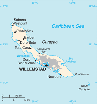
| Tuairisc |
English: Map of Curaçao from the 2010-10-22 revision of the World Factbook |
| Dáta | |
| Foinse | World Factbook website |
| Údar | Directorate of Intelligence, CIA |
Ceadúnú
This image is in the public domain because it contains materials that originally came from the United States Central Intelligence Agency's World Factbook.
|
 |
Stair chomhaid
Cliceáil ar dáta/am chun an comhad a radharc mar a bhí sé ag an am sin.
| Dáta/Am | Mionsamhail | Toisí | Úsáideoir | Nóta tráchta | |
|---|---|---|---|---|---|
| faoi láthair | 11:13, 23 Bealtaine 2018 | | 325 × 349 (11 KB) | Ras67 | cropped, opt. |
| 11:21, 23 Deireadh Fómhair 2010 |  | 330 × 353 (13 KB) | Hoshie | {{Information |Description= Map of {{w|Curaçao}} from the 2010-10-22 revision of the World Factbook |Source= [https://www.cia.gov/library/publications/the-world-factbook/maps/maptemplate_cc.html World Factbook website] |Date= 2010-10-22 |Author= Director |
Úsáid comhaid
Tá nasc chuig an gcomhad seo ar na leathanaigh seo a leanas:
Global file usage
The following other wikis use this file:
- Úsáid ar als.wikipedia.org
- Úsáid ar ast.wikipedia.org
- Úsáid ar ba.wikipedia.org
- Úsáid ar be-tarask.wikipedia.org
- Úsáid ar br.wikipedia.org
- Úsáid ar ca.wikipedia.org
- Úsáid ar cs.wikipedia.org
- Úsáid ar de.wikipedia.org
- Úsáid ar en.wikipedia.org
- Úsáid ar es.wikipedia.org
- Úsáid ar eu.wikipedia.org
- Úsáid ar fi.wikipedia.org
- Úsáid ar frr.wikipedia.org
- Úsáid ar gl.wikipedia.org
- Úsáid ar he.wikipedia.org
- Úsáid ar hu.wikipedia.org
- Úsáid ar id.wikipedia.org
- Úsáid ar incubator.wikimedia.org
- Úsáid ar io.wikipedia.org
- Úsáid ar ja.wikipedia.org
- Úsáid ar ms.wikipedia.org
- Úsáid ar mt.wikipedia.org
- Úsáid ar nn.wikipedia.org
- Úsáid ar no.wikipedia.org
- Úsáid ar pl.wikipedia.org
- Úsáid ar pl.wiktionary.org
- Úsáid ar ru.wikipedia.org
- Úsáid ar sl.wikipedia.org
- Úsáid ar sw.wikipedia.org
- Úsáid ar ta.wikipedia.org
- Úsáid ar th.wikipedia.org
- Úsáid ar to.wikipedia.org
- Úsáid ar tt.wikipedia.org
- Úsáid ar uk.wikipedia.org
- Úsáid ar ur.wikipedia.org
- Úsáid ar vi.wikipedia.org
- Úsáid ar www.wikidata.org
View more global usage of this file.