
Íomhá:CornwallKernowMappa.png
Size of this preview: 800 × 587 picteilín. Other resolutions: 320 × 235 picteilín | 640 × 469 picteilín | 952 × 698 picteilín.
Taispeáin leagan ardtaifigh den íomhá (952 × 698 picteilín, méid comhaid: 167 KB, cineál MIME: image/png)
| Seo comhad as An Cómhaoin Viciméid. Tá an tuairisc as an leathanach tuairisc Cómhaoin a leanas thíos.
|
Achoimriú
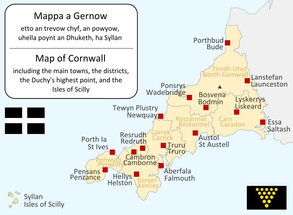
I made this map myself in September 2004. It is bilingual in Cornish and English, and shows the modern-day administrative boundaries of Cornwall and the larger towns. QuartierLatin1968 17:36, 14 Apr 2005 (UTC)

|
Tugtar cead an doiciméad seo a chóipeáil, a dháileadh agus/nó a mhodhnú faoi théarmaí an Ceadúnas Doiciméadúcháin Saor ó GNU, Leagan 1.2 nó aon leagan níos déanaí a d’fhoilsigh an Fondúireacht Bogearraí Saor in Aisce; gan aon Rannóga Inmheánacha, gan aon Téacsanna Clúdaigh Tosaigh, agus gan aon Téacsanna Clúdaigh Cúil. Tá cóip den cheadúnas san áireamh sa chuid dar teideal Ceadúnas Doiciméadúcháin Saor ó GNU. |
| This file is licensed under the Creative Commons Attribution-Share Alike 3.0 Unported license. | ||
| ||
| This licensing tag was added to this file as part of the GFDL licensing update. |
| Annotations | This image is annotated: View the annotations at Commons |
Stair chomhaid
Cliceáil ar dáta/am chun an comhad a radharc mar a bhí sé ag an am sin.
| Dáta/Am | Mionsamhail | Toisí | Úsáideoir | Nóta tráchta | |
|---|---|---|---|---|---|
| faoi láthair | 19:09, 23 Meitheamh 2011 | | 952 × 698 (167 KB) | Lader Gwiader | improve, SWF, place names from "A Concise Dictionary of Cornish Place Names" |
| 04:38, 21 Lúnasa 2005 |  | 643 × 469 (30 KB) | QuartierLatin1968 | one or two grammatical fixes, less jarring colours | |
| 17:33, 14 Aibreán 2005 |  | 644 × 474 (21 KB) | QuartierLatin1968 | I made this map myself in September 2004. It is bilingual in Cornish and English, and shows the modern-day administrative boundaries of Cornwall and the larger towns. {{GFDL}} |
Úsáid comhaid
Níl nasc ó aon leathanach eile don íomhá seo.
Global file usage
The following other wikis use this file:
- Úsáid ar af.wikipedia.org
- Úsáid ar an.wikipedia.org
- Úsáid ar ast.wikipedia.org
- Úsáid ar br.wikipedia.org
- Úsáid ar ca.wikipedia.org
- Úsáid ar cs.wikipedia.org
- Úsáid ar cy.wikipedia.org
- Úsáid ar el.wiktionary.org
- Úsáid ar en.wikipedia.org
- Úsáid ar eo.wikipedia.org
- Úsáid ar es.wikipedia.org
- Úsáid ar frr.wikipedia.org
- Úsáid ar fr.wikipedia.org
- Úsáid ar fy.wikipedia.org
- Úsáid ar gd.wikipedia.org
- Úsáid ar he.wikipedia.org
- קורנית (שפה)
- תבנית:הידעת? 10 ביולי - סדרה 2
- פורטל:הממלכה המאוחדת/הידעת?/קטעי הידעת?
- פורטל:בלשנות/הידעת?/קטעי הידעת
- פורטל:בלשנות/הידעת?/10
- פורטל:הממלכה המאוחדת/הידעת?/17
- תבנית:הידעת? 10 ביולי 2013
- ויקיפדיה:הידעת?/2013/יולי
- ויקיפדיה:הידעת?/2016/יולי
- תבנית:הידעת? 12 ביולי 2016
- ויקיפדיה:הידעת?/2018/יולי
- תבנית:הידעת? 19 ביולי 2018
- ויקיפדיה:הידעת?/2019/יולי
- תבנית:הידעת? 10 ביולי 2019
View more global usage of this file.