
Íomhá:Comanche County Oklahoma Incorporated areas highlighting Lawton.svg

Size of this PNG preview of this SVG file: 582 × 599 picteilín. Other resolutions: 233 × 240 picteilín | 466 × 480 picteilín | 746 × 768 picteilín | 995 × 1,024 picteilín | 1,990 × 2,048 picteilín.
Taispeáin leagan ardtaifigh den íomhá (Comhad SVG, ainmniúil 582 × 599 picteilíni, méid comhaid: 801 KB)
| Seo comhad as An Cómhaoin Viciméid. Tá an tuairisc as an leathanach tuairisc Cómhaoin a leanas thíos.
|
Achoimriú
| Tuairisc |
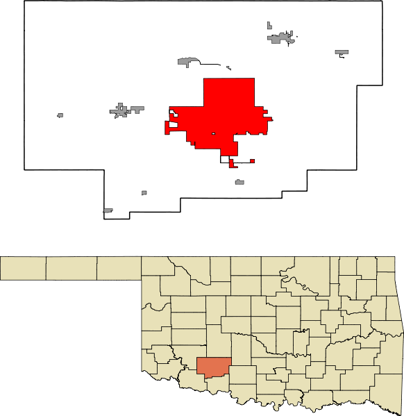
English: A map highlighting the city of Lawton in Comanche County in the US state of Oklahoma. Data provided from geo.ou.edu Based on similar maps from Ixnayonthetimmay |
| Dáta | |
| Foinse | Obair féin |
| Údar | Crimsonedge34 |
| SVG genesis |
Ceadúnú
Is mise sealbhóir cóipchirt an shaothair seo agus foilsím é faoin gceadúnas seo a leanas:
| This file is made available under the Creative Commons CC0 1.0 Universal Public Domain Dedication. | |
| The person who associated a work with this deed has dedicated the work to the public domain by waiving all of their rights to the work worldwide under copyright law, including all related and neighboring rights, to the extent allowed by law. You can copy, modify, distribute and perform the work, even for commercial purposes, all without asking permission.
|
Stair chomhaid
Cliceáil ar dáta/am chun an comhad a radharc mar a bhí sé ag an am sin.
| Dáta/Am | Mionsamhail | Toisí | Úsáideoir | Nóta tráchta | |
|---|---|---|---|---|---|
| faoi láthair | 07:47, 13 Deireadh Fómhair 2011 | | 582 × 599 (801 KB) | Crimsonedge34 | Margins |
| 06:49, 13 Deireadh Fómhair 2011 |  | 692 × 646 (727 KB) | Crimsonedge34 | Would help if I uploaded the correct map. | |
| 06:48, 13 Deireadh Fómhair 2011 |  | 1,052 × 744 (42 KB) | Crimsonedge34 | {{Information |Description ={{en|1=A map highlighting the city of Lawton in Comanche County in the US state of Oklahoma. Based on similar maps from Ixnayonthetimmay}} |Source ={{own}} |Author =[[User:Crimso |
Úsáid comhaid
Tá nasc chuig an gcomhad seo ar na leathanaigh seo a leanas:
Global file usage
The following other wikis use this file:
- Úsáid ar ar.wikipedia.org
- Úsáid ar arz.wikipedia.org
- Úsáid ar azb.wikipedia.org
- Úsáid ar br.wikipedia.org
- Úsáid ar ca.wikipedia.org
- Úsáid ar en.wikipedia.org
- Úsáid ar eu.wikipedia.org
- Úsáid ar fa.wikipedia.org
- Úsáid ar fi.wikipedia.org
- Úsáid ar fr.wikipedia.org
- Úsáid ar gd.wikipedia.org
- Úsáid ar ht.wikipedia.org
- Úsáid ar hu.wikipedia.org
- Úsáid ar ia.wikipedia.org
- Úsáid ar id.wikipedia.org
- Úsáid ar kw.wikipedia.org
- Úsáid ar no.wikipedia.org
- Úsáid ar pt.wikipedia.org
- Úsáid ar sh.wikipedia.org
- Úsáid ar simple.wikipedia.org
- Úsáid ar sr.wikipedia.org
- Úsáid ar sv.wikipedia.org
- Úsáid ar tr.wikipedia.org
- Úsáid ar tt.wikipedia.org
- Úsáid ar ur.wikipedia.org
- Úsáid ar vo.wikipedia.org
- Úsáid ar www.wikidata.org
- Úsáid ar zh.wikipedia.org