
Íomhá:Centre of Fordingbridge - geograph.org.uk - 1525645.jpg
Níl aon taifeach is mó ar fáil.
Centre_of_Fordingbridge_-_geograph.org.uk_-_1525645.jpg (640 × 426 picteilín, méid comhaid: 203 KB, cineál MIME: image/jpeg)
| Seo comhad as An Cómhaoin Viciméid. Tá an tuairisc as an leathanach tuairisc Cómhaoin a leanas thíos.
|
Achoimriú
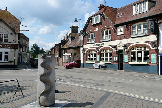
| Tuairisc |
English: Centre of Fordingbridge This is the junction of Provost Street (left), Shaftesbury Street (ahead) and High Street (right) that can be regarded as the town centre. The Ship Inn probably indicates a time when the River Avon was navigable as far as the town, and the town name clearly indicates that this was the ford and later the bridge over the river. I would appreciate information about the sculpture in the foreground. The sculpture is by Paul Wilson of Salisbury. (http://wilsonsculpture.co.uk/gallery.htm) |
| Dáta | |
| Foinse | From geograph.org.uk |
| Údar | Graham Horn |
| Creidiúint (required by the license) | Graham Horn / Centre of Fordingbridge / |
| Camera location | | View this and other nearby images on: OpenStreetMap |
|---|
_heading:292.00&language=ga)
| Object location | | View this and other nearby images on: OpenStreetMap |
|---|
_heading:292.00&language=ga)
Ceadúnú

|
This image was taken from the Geograph project collection. See this photograph's page on the Geograph website for the photographer's contact details. The copyright on this image is owned by Graham Horn and is licensed for reuse under the Creative Commons Attribution-ShareAlike 2.0 license.
|
This file is licensed under the Creative Commons Attribution-Share Alike 2.0 Generic license.
Creidiúint: Graham Horn
- Is féidir:
- an saothar seo a roinnt – an saothar seo a chóipeáil, a dháil amach, agus a tharchur
- an saothar seo a athmheascadh – an saothar seo a oiriúnú
- Ach amháin má leantar na coinníollacha seo a leanas:
- sannadh – Ní mor creidiúint a thabhairt leis an saothar, faoi mar a shonraigh an údar nó tabharthóir an ceadúnais (ach ná húsáid modh a thugann le fios go thacaíonn sé/sí tú féin nó an úsáid a bhaineann tú as an saothar).
- comhroinn araon – Má athraíonn tú nó síneann tú amach an saothar seo, ní féidir é a dháileadh ach amhaín faoin gceadúnas céanna nó ceann cosúil leis an gceann seo.
Stair chomhaid
Cliceáil ar dáta/am chun an comhad a radharc mar a bhí sé ag an am sin.
| Dáta/Am | Mionsamhail | Toisí | Úsáideoir | Nóta tráchta | |
|---|---|---|---|---|---|
| faoi láthair | 02:51, 3 Márta 2011 | | 640 × 426 (203 KB) | GeographBot | == {{int:filedesc}} == {{Information |description={{en|1=Centre of Fordingbridge This is the junction of Provost Street (left), Shaftesbury Street (ahead) and High Street (right) that can be regarded as the town centre. The Ship Inn probably indicates a |
Úsáid comhaid
Tá nasc chuig an gcomhad seo ar na leathanaigh seo a leanas:
Global file usage
The following other wikis use this file:
- Úsáid ar azb.wikipedia.org
- Úsáid ar ceb.wikipedia.org
- Úsáid ar cy.wikipedia.org
- Úsáid ar de.wikipedia.org
- Úsáid ar en.wikivoyage.org
- Úsáid ar es.wikipedia.org
- Úsáid ar fa.wikipedia.org
- Úsáid ar fr.wikipedia.org
- Úsáid ar it.wikipedia.org
- Úsáid ar lld.wikipedia.org
- Úsáid ar nl.wikipedia.org
- Úsáid ar ro.wikipedia.org
- Úsáid ar sv.wikipedia.org
- Úsáid ar www.wikidata.org