
Íomhá:Carte armenie francais.gif
Níl aon taifeach is mó ar fáil.
Carte_armenie_francais.gif (330 × 354 picteilín, méid comhaid: 12 KB, cineál MIME: image/gif)
| Seo comhad as An Cómhaoin Viciméid. Tá an tuairisc as an leathanach tuairisc Cómhaoin a leanas thíos.
|
Achoimriú
Author : TL
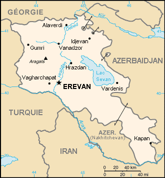
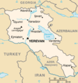
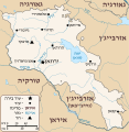
This picture is the french translation of a map from The CIA World Fact Book, representing Armenia and its region.
- Other versions
[]
-
 English(New version)
 -
 English
 -
 español
 -
 čeština
 -
 français
 -
 Türkçe
 -
 українська
 -
 עברית (SVG)


Ceadúnú
This image is in the public domain because it contains materials that originally came from the United States Central Intelligence Agency's World Factbook.
|
 |
| I, the copyright holder of this work, release this work into the public domain. This applies worldwide. In some countries this may not be legally possible; if so: I grant anyone the right to use this work for any purpose, without any conditions, unless such conditions are required by law. |
Stair chomhaid
Cliceáil ar dáta/am chun an comhad a radharc mar a bhí sé ag an am sin.
| Dáta/Am | Mionsamhail | Toisí | Úsáideoir | Nóta tráchta | |
|---|---|---|---|---|---|
| faoi láthair | 14:08, 17 Meitheamh 2006 | | 330 × 354 (12 KB) | Sting | "Géorgie" |
| 16:14, 2 Márta 2006 |  | 330 × 354 (11 KB) | TL | Author : TL This picture is the french translation of a map from The CIA World Fact Book, representing Armenia and its region. |
Úsáid comhaid
Tá nasc chuig an gcomhad seo ar na leathanaigh seo a leanas:
Global file usage
The following other wikis use this file:
- Úsáid ar azb.wikipedia.org
- Úsáid ar de.wikinews.org
- Úsáid ar fr.wikipedia.org
- Úsáid ar ja.wikipedia.org
- Úsáid ar mg.wikipedia.org
- Úsáid ar pcd.wikipedia.org
- Úsáid ar pl.wikinews.org
- Úsáid ar pl.wiktionary.org
- Úsáid ar sr.wikinews.org
- Úsáid ar ug.wikipedia.org