
Íomhá:CapeCodTowns.jpg
Níl aon taifeach is mó ar fáil.
CapeCodTowns.jpg (800 × 600 picteilín, méid comhaid: 63 KB, cineál MIME: image/jpeg)
| Seo comhad as An Cómhaoin Viciméid. Tá an tuairisc as an leathanach tuairisc Cómhaoin a leanas thíos.
|
Achoimriú
| Tuairisc |
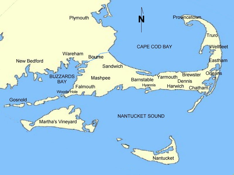
English: Map of Cape Cod town locations. Drawn by uploader based on National Atlas (U.S. Govt) outline. Released to public domain. |
| Dáta | 18 Meitheamh 2006 (original upload date) |
| Foinse | Obair féin |
| Údar | User: (WT-shared) OldPine at wts wikivoyage |
| Suíomh | Cape Cod |
Ceadúnú
| This work has been released into the public domain by its author, User: (WT-shared) OldPine at wts wikivoyage. This applies worldwide. In some countries this may not be legally possible; if so: User: (WT-shared) OldPine at wts wikivoyage grants anyone the right to use this work for any purpose, without any conditions, unless such conditions are required by law.
|
Original upload log
| This file was imported from Wikivoyage WTS. |
The original description page was here. All following user names refer to wts.wikivoyage-old.
- 2006-06-22 00:09 (WT-shared) OldPine[dead link] 800×600 (64576 bytes) Map of Cape Cod Town locations. Drawn by uploader based on National Atlas outline. Released to public domain. (Import from wikitravel.org/shared)
- 2006-06-18 20:04 (WT-shared) OldPine[dead link] 800×600 (64576 bytes) Map of Cape Cod town locations. Drawn by uploader based on National Atlas (U.S. Govt) outline. Released to public domain. (Import from wikitravel.org/shared)
Stair chomhaid
Cliceáil ar dáta/am chun an comhad a radharc mar a bhí sé ag an am sin.
| Dáta/Am | Mionsamhail | Toisí | Úsáideoir | Nóta tráchta | |
|---|---|---|---|---|---|
| faoi láthair | 15:03, 18 Nollaig 2012 | | 800 × 600 (63 KB) | MGA73bot2 | {{BotMoveToCommons|wts.oldwikivoyage|year={{subst:CURRENTYEAR}}|month={{subst:CURRENTMONTHNAME}}|day={{subst:CURRENTDAY}}}} == {{int:filedesc}} == {{Information |description=Map of Cape Cod town locations. Drawn by uploader based on National Atlas (U.S... |
Úsáid comhaid
Níl nasc ó aon leathanach eile don íomhá seo.
Global file usage
The following other wikis use this file:
- Úsáid ar de.wikivoyage.org
- Úsáid ar fr.wikivoyage.org
- Úsáid ar gd.wikipedia.org
- Úsáid ar nl.wikipedia.org