
Íomhá:Cameroon boundary changes.PNG

Size of this preview: 710 × 600 picteilín. Other resolutions: 284 × 240 picteilín | 568 × 480 picteilín | 910 × 768 picteilín | 1,213 × 1,024 picteilín | 2,000 × 1,689 picteilín.
Taispeáin leagan ardtaifigh den íomhá (2,000 × 1,689 picteilín, méid comhaid: 170 KB, cineál MIME: image/png)
| Seo comhad as An Cómhaoin Viciméid. Tá an tuairisc as an leathanach tuairisc Cómhaoin a leanas thíos.
|

|
This map image could be re-created using vector graphics as an SVG file. This has several advantages; see Commons:Media for cleanup for more information. If an SVG form of this image is available, please upload it and afterwards replace this template with
{{vector version available|new image name}}.
It is recommended to name the SVG file “Cameroon boundary changes.svg”—then the template Vector version available (or Vva) does not need the new image name parameter. |
Achoimriú
| Tuairisc |
Deutsch: Änderung des Grenzverlaufs von Kamerun
English: Boundary changes in Cameroon (English)
Français : Évolution des frontières du Cameroun entre 1901 et 1972 (anglais)
Italiano: Evoluzione delle frontiere del Camerun tra il 1901 ed il 1972
Português: Mudança na fronteira dos Camarões
Deutsch: Die deutsche Kolonie Kamerun
English: German colony of Kamerun
Français : Colonie allemande du Cameroun
Italiano: Camerun tedesco
Deutsch: Cameroons
English: British Cameroons
Français : Cameroun britannique
Italiano: Camerun britannico
Deutsch: Französisch-Kamerun
English: French Cameroun
Français : Cameroun français
Italiano: Camerun francese
Deutsch: Unabhängiges Kamerun
English: Independent Cameroon
Français : Cameroun indépendant
Italiano: Camerun indipendente |
| Dáta | |
| Foinse | Self-made based on public domain CIA map Image:Cameroon Map.jpg, original svg file located here. |
| Údar | Roke |
| Leaganacha eile |
|


|
File:Cameroon boundary changes-fr.svg is a vector version of this file. It should be used in place of this PNG file when not inferior.
File:Cameroon boundary changes.PNG → File:Cameroon boundary changes-fr.svg
For more information, see Help:SVG. |
 |
Reference
- German Cameroons 1914 archive copy at the Wayback Machine
- World Statesman, Cameroon
- Image:Southern cameroons.PNG - map of southern cameroons
- cameroon
- Kamerun 1912 archive copy at the Wayback Machine
- British Cameroons
Ceadúnú
Is mise sealbhóir cóipchirt an shaothair seo agus foilsím é faoi na ceadúnais seo a leanas:

|
Tugtar cead an doiciméad seo a chóipeáil, a dháileadh agus/nó a mhodhnú faoi théarmaí an Ceadúnas Doiciméadúcháin Saor ó GNU, Leagan 1.2 nó aon leagan níos déanaí a d’fhoilsigh an Fondúireacht Bogearraí Saor in Aisce; gan aon Rannóga Inmheánacha, gan aon Téacsanna Clúdaigh Tosaigh, agus gan aon Téacsanna Clúdaigh Cúil. Tá cóip den cheadúnas san áireamh sa chuid dar teideal Ceadúnas Doiciméadúcháin Saor ó GNU. |
| This file is licensed under the Creative Commons Attribution-Share Alike 3.0 Unported license. | ||
| ||
| This licensing tag was added to this file as part of the GFDL licensing update. |
This file is licensed under the Creative Commons Attribution-Share Alike 2.5 Generic, 2.0 Generic and 1.0 Generic license.
- Is féidir:
- an saothar seo a roinnt – an saothar seo a chóipeáil, a dháil amach, agus a tharchur
- an saothar seo a athmheascadh – an saothar seo a oiriúnú
- Ach amháin má leantar na coinníollacha seo a leanas:
- sannadh – Ní mor creidiúint a thabhairt leis an saothar, faoi mar a shonraigh an údar nó tabharthóir an ceadúnais (ach ná húsáid modh a thugann le fios go thacaíonn sé/sí tú féin nó an úsáid a bhaineann tú as an saothar).
- comhroinn araon – Má athraíonn tú nó síneann tú amach an saothar seo, ní féidir é a dháileadh ach amhaín faoin gceadúnas céanna nó ceann cosúil leis an gceann seo.
Is féidir leat a roghnú an ceadúnas do rogha
Stair chomhaid
Cliceáil ar dáta/am chun an comhad a radharc mar a bhí sé ag an am sin.
| Dáta/Am | Mionsamhail | Toisí | Úsáideoir | Nóta tráchta | |
|---|---|---|---|---|---|
| faoi láthair | 11:54, 18 Iúil 2007 | | 2,000 × 1,689 (170 KB) | Roke~commonswiki | more detailed |
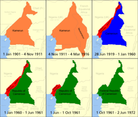
| 09:19, 11 Iúil 2006 |  | 508 × 680 (18 KB) | Roke~commonswiki | Boundary changes in w:Cameroon. *Orange = German colony of Kamerun *Red = British w:Cameroons after WWI (divided into separate Northern Cameroons and Southern Cameroons) *Blue = French Cameroun after WWI *Green = Independent Cameroon ("Northern Ca |
Úsáid comhaid
Tá nasc chuig an gcomhad seo ar na leathanaigh seo a leanas:
Global file usage
The following other wikis use this file:
- Úsáid ar af.wikipedia.org
- Úsáid ar als.wikipedia.org
- Úsáid ar ar.wikipedia.org
- Úsáid ar azb.wikipedia.org
- Úsáid ar be.wikipedia.org
- Úsáid ar bn.wikipedia.org
- Úsáid ar br.wikipedia.org
- Úsáid ar ca.wikipedia.org
- Úsáid ar cy.wikipedia.org
- Úsáid ar da.wikipedia.org
- Úsáid ar de.wikipedia.org
- Úsáid ar el.wikipedia.org
- Úsáid ar en.wikipedia.org
- History of Cameroon
- British Cameroon
- Kamerun
- Ambazonia
- Bafut, Cameroon
- Neukamerun
- Wikipedia:Graphics Lab/Images to improve/Archive/Apr 2007
- Baháʼí Faith in Cameroon
- French Cameroon
- List of colonial governors of Cameroon
- Anglophone Crisis
- Cameroon–Chad border
- User:Falcaorib
- Cameroon–Central African Republic border
- Cameroon–Nigeria border
- User:Ethanmcg/Kamerun
- Origins of the Anglophone Crisis
- Úsáid ar eo.wikipedia.org
- Úsáid ar fi.wikipedia.org
- Úsáid ar frr.wikipedia.org
- Úsáid ar fr.wikipedia.org
- Úsáid ar ha.wikipedia.org
View more global usage of this file.