
Íomhá:Byzantine Constantinople-en.svg

Size of this PNG preview of this SVG file: 662 × 600 picteilín. Other resolutions: 265 × 240 picteilín | 530 × 480 picteilín | 848 × 768 picteilín | 1,130 × 1,024 picteilín | 2,261 × 2,048 picteilín | 2,085 × 1,889 picteilín.
Taispeáin leagan ardtaifigh den íomhá (Comhad SVG, ainmniúil 2,085 × 1,889 picteilíni, méid comhaid: 3.69 MB)
| Seo comhad as An Cómhaoin Viciméid. Tá an tuairisc as an leathanach tuairisc Cómhaoin a leanas thíos.
|
Achoimriú
| Tuairisc |
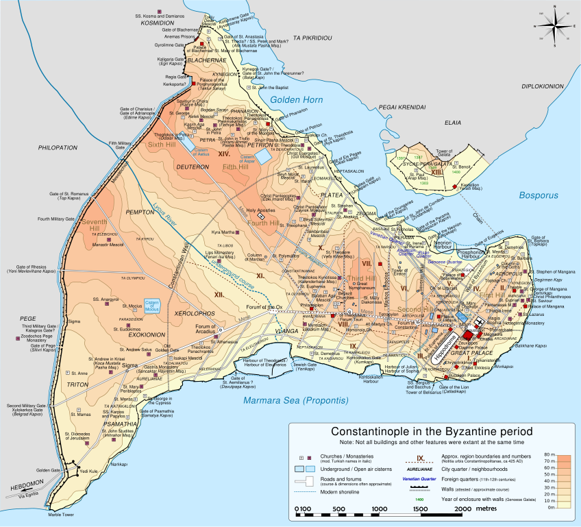
Deutsch: Topografische Karte Konstantinopels während des byzantinischen Zeitraums. Quelle: R. Janin, Constantinople Byzantine. Developpement urbain et repertoire topographique. Straßennetz und andere Einzelheiten basiert auf Dumbarton Oaks Papers 54. Kirchen, insb. nicht identifizierte und ausgegrabene Bauten sind aus dem The Byzantine Churches of Istanbul entnommen. Andere herausgegebenen Quellen wurden behilfsmäßig gebraucht. English: Topographical map of Constantinople during the Byzantine period. Main map source: R. Janin, Constantinople Byzantine. Developpement urbain et repertoire topographique. Road network and some other details based on Dumbarton Oaks Papers 54; data on many churches, especially unidentified ones, taken from the University of New York's The Byzantine Churches of Istanbul project. Other published maps and accounts of the city have been used for corroboration. Français : Carte en anglais de Constantinople à l'époque Byzantine. Source principale : R. Janin, Constantinople Byzantine. Développement urbain et répertoire topographique. Le réseau routier et d'autres détails proviennent de Dumbarton Oaks Papers 54. Les données concernant de nombreuses églises, en particulier celles non identifiées, viennent de l'université de New York : le projet The Byzantine Churches of Istanbul (Les églises byzantines d'Istanbul). D'autres cartes encore ont été utilisées pour recouper et vérifier les informations. Türkçe: tr:Konstantinopolis'in Bizans dönemindeki topografik haritası. Ana haritanın kaynağı: R. Janin, Constantinople Byzantine. Developpement urbain et repertoire topographique. Yol haritası ve bazı diğer ayrıntıların kaynağı: Dumbarton Oaks Papers 54; kiliseler, özellikle kimliği belirlenmemiş olanlar hakkında veriler, New York University'nin İstanbul'un Bizans Kiliseleri projesinden elde edilmiştir. Şehir hakkında yayımlanmış diğer harita ve metinler bu bilgileri doğrulamak için kullanılmıştır. Ελληνικά: Τοπογραφικός χάρτης Κωνσταντινουπόλεως κατά τη Βυζαντινή περίοδο. Βασική πηγή χάρτη: R. Janin, Constantinople Byzantine. Developpement urbain et repertoire topographique. Το οδικό δίκτυο και διάφορες άλλες λεπτομέρειες με βάση το Dumbarton Oaks Papers 54. Πληροφορίες για τις εκκλησίες, ιδιαίτερα τις μη ταυτοποιημένες, από την ιστοσελίδα The Byzantine Churches of Istanbul του Πανεπιστημίου της Νέας Υόρκης. Български: Топографска карта на Константинопол (Цариград) през византийския период. Източник: R. Janin, Constantinople Byzantine. Developpement urbain et repertoire topographique. Пътната мрежа и някои други детайли се основават на Dumbarton Oaks Papers 54 и други публикувани източници. |
||
| Dáta | |||
| Foinse | Obair féin | ||
| Údar | Cplakidas | ||
| Leaganacha eile |
[] Full mapsSVG:
PNG:
Numeric versions
Regions
Roads
Derivative works of this file: | ||
| SVG | W3C-validity not checked.
|


| Camera location | | View this and other nearby images on: OpenStreetMap |
|---|
Ceadúnú
Is mise sealbhóir cóipchirt an shaothair seo agus foilsím é faoi na ceadúnais seo a leanas:
This file is licensed under the Creative Commons Attribution-Share Alike 3.0 Unported license.
- Is féidir:
- an saothar seo a roinnt – an saothar seo a chóipeáil, a dháil amach, agus a tharchur
- an saothar seo a athmheascadh – an saothar seo a oiriúnú
- Ach amháin má leantar na coinníollacha seo a leanas:
- sannadh – Ní mor creidiúint a thabhairt leis an saothar, faoi mar a shonraigh an údar nó tabharthóir an ceadúnais (ach ná húsáid modh a thugann le fios go thacaíonn sé/sí tú féin nó an úsáid a bhaineann tú as an saothar).
- comhroinn araon – Má athraíonn tú nó síneann tú amach an saothar seo, ní féidir é a dháileadh ach amhaín faoin gceadúnas céanna nó ceann cosúil leis an gceann seo.

|
Tugtar cead an doiciméad seo a chóipeáil, a dháileadh agus/nó a mhodhnú faoi théarmaí an Ceadúnas Doiciméadúcháin Saor ó GNU, Leagan 1.2 nó aon leagan níos déanaí a d’fhoilsigh an Fondúireacht Bogearraí Saor in Aisce; gan aon Rannóga Inmheánacha, gan aon Téacsanna Clúdaigh Tosaigh, agus gan aon Téacsanna Clúdaigh Cúil. Tá cóip den cheadúnas san áireamh sa chuid dar teideal Ceadúnas Doiciméadúcháin Saor ó GNU. |
Is féidir leat a roghnú an ceadúnas do rogha
Stair chomhaid
Cliceáil ar dáta/am chun an comhad a radharc mar a bhí sé ag an am sin.
| Dáta/Am | Mionsamhail | Toisí | Úsáideoir | Nóta tráchta | |
|---|---|---|---|---|---|
| faoi láthair | 20:48, 13 Márta 2012 | | 2,085 × 1,889 (3.69 MB) | Sémhur | New version, with cleaned code and a new layer "editable text, hidden" made with font "Nimbus Sans L", containing all the texts, and other layers with text as path (not editables, but visibles). |
| 13:13, 15 Nollaig 2009 |  | 2,050 × 1,850 (8.13 MB) | Cplakidas | larger & improved version, various corrections, Galata included | |
| 22:53, 8 Eanáir 2009 |  | 1,600 × 1,500 (5.79 MB) | Cplakidas | {{Information |Description= |Source= |Date= |Author= |Permission= |other_versions= }} | |
| 23:26, 14 Samhain 2008 |  | 1,600 × 1,500 (5.29 MB) | Cplakidas | attempt to get text right | |
| 11:38, 28 Deireadh Fómhair 2008 |  | 1,600 × 1,500 (5.31 MB) | Cplakidas | final version (hopefully): added remaining churches & corrected locations, minor tweaks at places | |
| 19:10, 27 Deireadh Fómhair 2008 |  | 1,600 × 1,500 (4.81 MB) | Cplakidas | completed outer land wall, fixed Golden Gate, fixed sea walls & added known gates, minor location corrections & additions | |
| 17:46, 25 Deireadh Fómhair 2008 |  | 1,600 × 1,500 (2.74 MB) | Cplakidas | text into paths, enlarged map for improved readability | |
| 00:59, 24 Deireadh Fómhair 2008 |  | 1,180 × 1,120 (371 KB) | Cplakidas | restored Times New Roman. | |
| 00:39, 24 Deireadh Fómhair 2008 |  | 1,180 × 1,120 (369 KB) | Cplakidas | added posterns, alternate gate names, approx. roads in outer city, corrections on monastery locations, converted text to sans serif font | |
| 22:47, 23 Deireadh Fómhair 2008 |  | 1,180 × 1,120 (328 KB) | Cplakidas | Reverted to version as of 23:25, 14 October 2008 |
Úsáid comhaid
Níl nasc ó aon leathanach eile don íomhá seo.
Global file usage
The following other wikis use this file:
- Úsáid ar ca.wikipedia.org
- Úsáid ar en.wikipedia.org
- Úsáid ar es.wikipedia.org
- Úsáid ar pl.wikipedia.org
- Úsáid ar sw.wikipedia.org