
Íomhá:Battle of Culloden (campaign map 01).png
Size of this preview: 800 × 400 picteilín. Other resolutions: 320 × 160 picteilín | 640 × 320 picteilín.
Taispeáin leagan ardtaifigh den íomhá (1,200 × 600 picteilín, méid comhaid: 376 KB, cineál MIME: image/png)
| Seo comhad as An Cómhaoin Viciméid. Tá an tuairisc as an leathanach tuairisc Cómhaoin a leanas thíos.
|
.png)
Achoimriú
| Tuairisc |
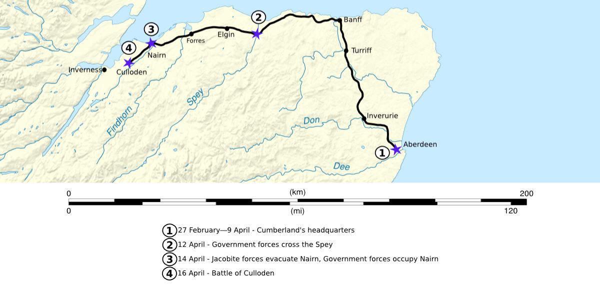
English: Map showing the advance of Government forces led by Cumberland, in the spring of 1746. The route shown ends at the site of the Battle of Culloden. |
| Dáta | 2 Nollaig 2008 (original upload date) |
| Foinse | The actual map was created using the following map found on the commons File:Scotland map-en.svg by User:Sting. |
| Údar | Celtus (talk) |
Ceadúnú
Is mise Celtus ar an Vicipéid Béarla, sealbhóir cóipchirt an shaothair seo, agus foilsím é faoi na ceadúnais seo a leanas:
This file is licensed under the Creative Commons Attribution-Share Alike 3.0 Unported license.
Creidiúint: Celtus ar an Vicipéid Béarla
- Is féidir:
- an saothar seo a roinnt – an saothar seo a chóipeáil, a dháil amach, agus a tharchur
- an saothar seo a athmheascadh – an saothar seo a oiriúnú
- Ach amháin má leantar na coinníollacha seo a leanas:
- sannadh – Ní mor creidiúint a thabhairt leis an saothar, faoi mar a shonraigh an údar nó tabharthóir an ceadúnais (ach ná húsáid modh a thugann le fios go thacaíonn sé/sí tú féin nó an úsáid a bhaineann tú as an saothar).
- comhroinn araon – Má athraíonn tú nó síneann tú amach an saothar seo, ní féidir é a dháileadh ach amhaín faoin gceadúnas céanna nó ceann cosúil leis an gceann seo.
Original upload log
The original description page was here. All following user names refer to en.wikipedia.
- 2008-12-02 06:24 Celtus 1200×600× (384578 bytes) {{Information |Description=Map showing the advance of Government forces led by [[William Augustus Cumberland|Cumberland]], in the spring of 1746. The route ends at the site of the [[Battle of Culloden]]. |Source=I created this work entirely by myself. |Da
Stair chomhaid
Cliceáil ar dáta/am chun an comhad a radharc mar a bhí sé ag an am sin.
| Dáta/Am | Mionsamhail | Toisí | Úsáideoir | Nóta tráchta | |
|---|---|---|---|---|---|
| faoi láthair | 17:23, 25 Iúil 2010 | | 1,200 × 600 (376 KB) | Friedlibend und tapfer | {{Information |Description={{en|Map showing the advance of Government forces led by Cumberland, in the spring of 1746. The route shown ends at the site of the en:Battle of Culloden.}} |Source=Transferred from [htt |
Úsáid comhaid
Tá nasc chuig an gcomhad seo ar na leathanaigh seo a leanas:
Global file usage
The following other wikis use this file:
- Úsáid ar azb.wikipedia.org
- Úsáid ar bg.wikipedia.org
- Úsáid ar en.wikipedia.org
- Úsáid ar fr.wikipedia.org
- Úsáid ar it.wikipedia.org
- Úsáid ar ru.wikipedia.org
.png)